Probability of damaging thunderstorm winds or wind gusts of 50 knots or higher within 25 miles of a point. Hatched Area: 10% of greater probability of wind gusts 65 knots or greater within 25 miles of a point.
SPC AC 251728
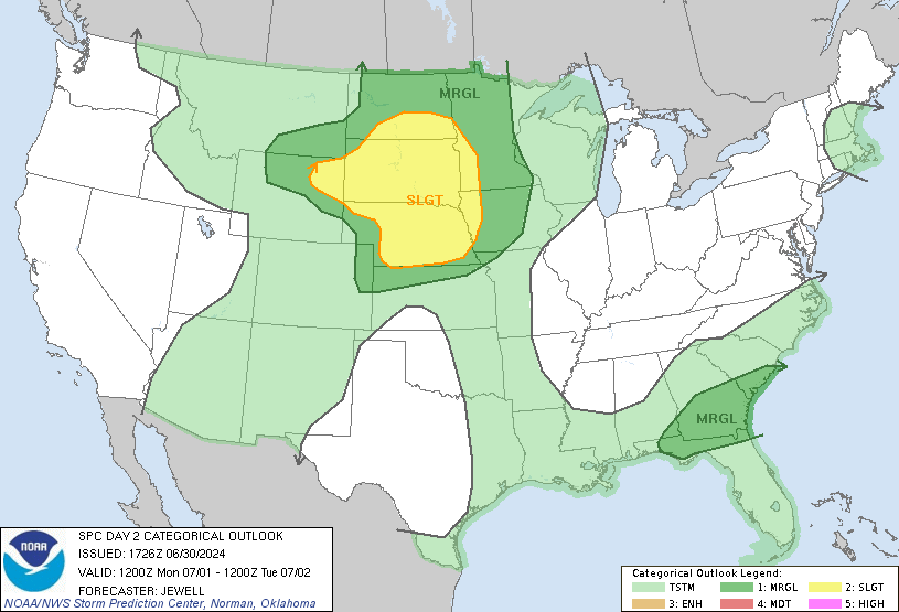
Day 2 Convective Outlook
NWS Storm Prediction Center Norman OK
1228 PM CDT Fri Apr 25 2025
Valid 261200Z - 271200Z
...THERE IS A MARGINAL RISK OF SEVERE THUNDERSTORMS ACROSS PORTIONS
OF EASTERN NEW MEXICO AND ADJACENT WESTERN TEXAS...
...SUMMARY...
A couple of strong to severe thunderstorms are possible on Saturday
across portions of eastern New Mexico into adjacent western Texas.
...Synopsis...
Large-scale ridging aloft will persist across the central U.S.
Saturday, as short-wave troughing over the Great Lakes region moves
into/across the Lower Lakes/Northeast, and a western U.S. upper low
makes slow eastward progress across California and into Nevada.
At the surface, a cold front will shift eastward across the
Northeast and Mid-Atlantic region, while trailing westward across
the Gulf Coast states and into the southern Plains.
...Parts of eastern New Mexico and adjacent western Texas...
Widespread convection is forecast to be ongoing at the start of the
period within a zone from far eastern New Mexico eastward to
Oklahoma/North Texas. Resulting cloud cover and likely southward
progression of outflow across western Texas casts some uncertainty
with respect to recovery of the afternoon airmass across the MRGL
risk area. Presuming ample heating occurs, isolated, new-storm
development -- likely near remnant outflow -- may pose additional
potential for local, all-hazards severe potential. This area will
likely require some adjustment in later outlooks, as the effects of
early-day convection can be more accurately ascertained.
..Goss.. 04/25/2025
NOTE: THE NEXT DAY 2 OUTLOOK IS SCHEDULED BY 0600Z