Little Rock, AR...Waco, TX...Abilene, TX...Wichita Falls, TX...Lawton, OK...
Probabilistic Damaging Wind Graphic
Probability of damaging thunderstorm winds or wind gusts of 50 knots or higher within 25 miles of a point. Hatched Area: 10% of greater probability of wind gusts 65 knots or greater within 25 miles of a point.
San Antonio, TX...Austin, TX...Oklahoma City, OK...St. Louis, MO...Cincinnati, OH...
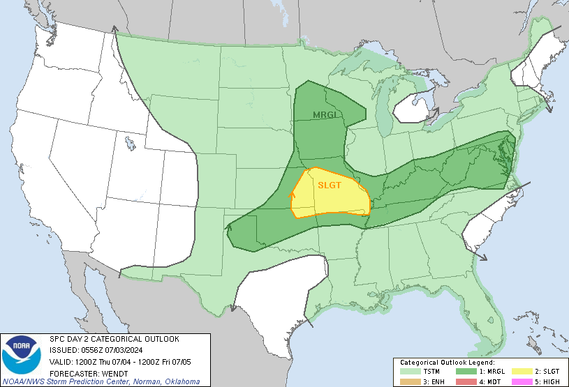
   SPC AC 290552

   Day 2 Convective Outlook
   NWS Storm Prediction Center Norman OK
   1252 AM CDT Tue Apr 29 2025

   Valid 301200Z - 011200Z

   ...THERE IS A SLIGHT RISK OF SEVERE THUNDERSTORMS NORTH-CENTRAL
   TEXAS...SOUTHEASTERN OKLAHOMA...WESTERN/CENTRAL ARKANSAS...

   ...SUMMARY...
   Scattered severe thunderstorms are possible on Wednesday, centered
   on central Texas to eastern Oklahoma and western Arkansas. Large
   hail, damaging wind, and a few tornadoes will be possible with
   thunderstorm activity.

   ...Synopsis...
   A shortwave trough is expected to move eastward across the Southern
   Plains on Wednesday, with multiple rounds of thunderstorm activity
   possible across portions of Texas and Oklahoma. At the start of the
   period Wednesday morning, convection should be ongoing across
   western Oklahoma into northern Texas near the surface low. This
   activity will continue to track eastward through the period and
   intensify through the afternoon/evening, as the surface low moves
   north and eastward. Additional thunderstorm development is expected
   along the southern fringe near the dryline in north-central Texas.

   A warm front extending across portions of Missouri, southern
   Indiana, southern Illinois into northern Kentucky may be the focus
   of strong to severe thunderstorm development Wednesday afternoon.

   ...Southern Plains into the Lower Mississippi Valley...
   The aforementioned thunderstorm activity early in the period
   Wednesday morning is expected to intensify through the afternoon, as
   daytime heating and increasing moisture leads to destabilization
   downstream in the warm sector. By the afternoon, the dryline across
   central Texas will be the focus of new development as upper level
   forcing overspreads the region. With multiple rounds of convection
   expected across the Texas Panhandle into western Oklahoma and north
   Texas in the D1 period, there is some uncertainty on where all the
   mesoscale features will be as this occurs. Nonetheless, it appears
   that ahead of the dryline the environment will be characterized by
   steep lapse rates, modest MLCAPE, and strong deep layer shear. This
   will support potential for a few supercells initially capable of
   very large hail. Should the mode remain favorable, the tornado risk
   will increase through the afternoon as the low-level jet strengthens
   and low-level curvature of hodographs increases. A more favorable
   corridor for tornadoes may exist near the Red River across
   southeastern Oklahoma/northern Texas. Upscale growth will promote
   potential for damaging wind, especially across eastern Oklahoma into
   western Arkansas. However, shear will also support potential for
   line embedded circulations.

   Additional thunderstorms may re-develop further west across the
   Texas Panhandle Wednesday afternoon, with potential for large hail.
   At this time, it is uncertain how much recovery can happen from
   multiple rounds of convection late D1 into D2 across this region.

   ...Lower MO/OH Valleys...
   Along the warm front from southern Indiana into southern Illinois
   and northern Kentucky, thunderstorm development is possible
   Wednesday afternoon. Forcing remains weaker across this region, with
   the shortwave back in the southern Plains. However, profiles would
   be supportive of a supercell or two in this region, given the plume
   of steep low to mid-level lapse rates, buoyancy, and sufficient
   shear. These would be capable of hail, severe wind, and potentially
   a tornado. For now, some uncertainty on coverage keeps probabilities
   low.

   ..Thornton/Bentley.. 04/29/2025

   NOTE: THE NEXT DAY 2 OUTLOOK IS SCHEDULED BY 1730Z