Shreveport, LA...Little Rock, AR...Waco, TX...Killeen, TX...Fort Smith, AR...
2 %
207,763
17,411,316
San Antonio, TX...Austin, TX...St. Louis, MO...Louisville, KY...Lubbock, TX...
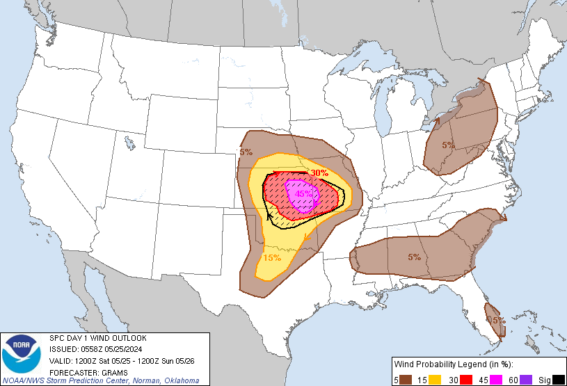
Probabilistic Damaging Wind Graphic
Probability of damaging thunderstorm winds or wind gusts of 50 knots or higher within 25 miles of a point. Hatched Area: 10% of greater probability of wind gusts 65 knots or greater within 25 miles of a point.
San Antonio, TX...Indianapolis, IN...Austin, TX...Oklahoma City, OK...St. Louis, MO...
SPC AC 300602
Day 1 Convective Outlook
NWS Storm Prediction Center Norman OK
0102 AM CDT Wed Apr 30 2025
Valid 301200Z - 011200Z
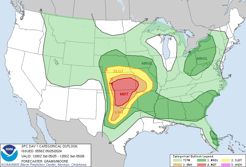
...THERE IS AN ENHANCED RISK OF SEVERE THUNDERSTORMS FROM
NORTH-CENTRAL TX INTO SOUTHEAST OK...SOUTHWEST AR...AND EXTREME
NORTHWEST LA...
...SUMMARY...
Scattered severe thunderstorms are possible on later today into this
evening, with the greatest risk expected across north-central Texas
into the ArkLaTex region. Large to very large hail, damaging winds,
and tornadoes are all possible, with some strong-tornado potential.
...Synopsis...
A mid/upper-level trough will move across the southern Plains today.
A surface low will move southwest into northeast TX, along an
outflow-reinforced front. Farther east, a warm front will move
northward across parts of the mid MS Valley, and remain nearly
stationary into parts of the Mid Atlantic.
...Southern Plains into the ArkLaTex/Ozarks...
An MCS may be ongoing during the morning near the Red River Valley
vicinity. This MCS may reintensify as it moves into a moist and
unstable environment from eastern OK into western AR, accompanied by
a threat for damaging winds, along with a localized hail/tornado
threat. The effective front/outflow position will be modulated by
this potential MCS, but this boundary will likely reside somewhere
across north-central/northeast TX during the afternoon. Near/south
of the boundary, diurnal heating of the moist airmass will result in
scattered thunderstorm development during the afternoon, with
deep-layer shear profiles supporting supercell development.
Large to very large hail will be a threat with any initial
supercells. Also, with the approach of the mid/upper-level shortwave
trough and attendant surface low, low-level flow is expected to
remain rather strong through the day, supporting sufficient SRH for
a tornado threat with any surface-based supercells, including some
localized strong tornado potential. While uncertainty remains
regarding mesoscale details regarding the outflow boundary, there is
sufficient confidence in a corridor of supercell development for the
addition of an Enhanced Risk. Eventual storm clustering could lead
to development of a nocturnal MCS that could eventually approach
parts of the lower MS Valley, with at least an isolated severe
threat.
Additional strong to severe storms will be possible across parts of
west TX, in closer proximity to the remnant midlevel low. Cold
temperatures aloft and steep lapse rates will support a threat of
hail and localized severe gusts, even though deep-layer flow/shear
will be more modest within this regime. These storms may eventually
spread toward southwest OK/northwest TX before weakening.
...Parts of MS/OH Valleys...
An MCV may move across parts of the MS/OH Valleys during the day, in
the vicinity of the northward-moving warm front. Scattered storms
may develop near the front during the afternoon, within a moist and
destabilizing airmass. There is some potential for at least
transient storm organization in the vicinity of the frontal zone,
with an attendant threat for hail, locally damaging wind, and
possibly a tornado. Uncertainty remains regarding the potential for
early convection/cloudiness to disrupt destabilization in this area,
but higher severe probabilities may eventually be needed if trends
support robust storm development during the afternoon/evening.
...Southern VA/northern NC...
Scattered storm development will be possible near the front across
parts of VA/NC. Deep-layer flow/shear will generally be weak, but
steep low-level lapse rates could support locally damaging outflow
winds with the strongest storms.
..Dean/Weinman.. 04/30/2025
NOTE: THE NEXT DAY 1 OUTLOOK IS SCHEDULED BY 1300Z