|
| Mesoscale Discussion 1534 |
|
< Previous MD Next MD >
|
|
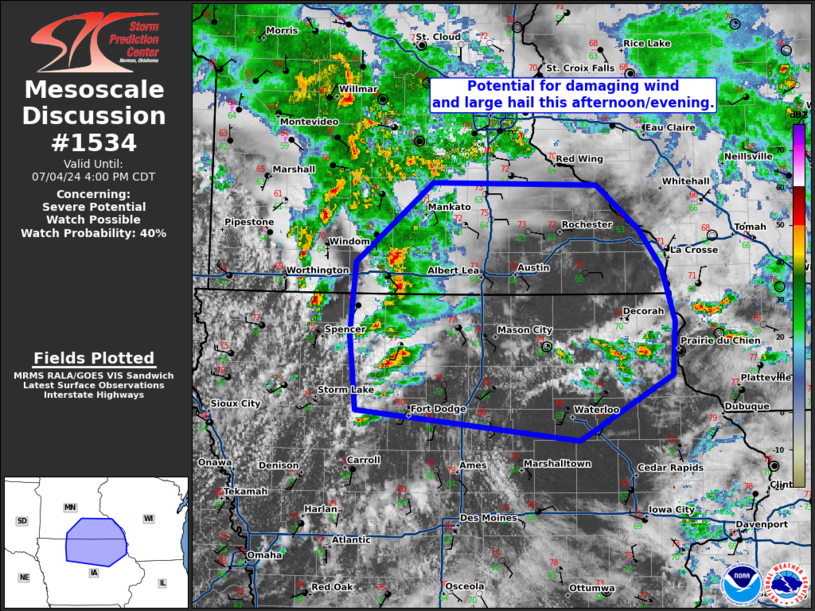
   Mesoscale Discussion 1534
   NWS Storm Prediction Center Norman OK
   0158 PM CDT Thu Jul 04 2024

   Areas affected...central/northern Iowa...southern Minnesota

   Concerning...Severe potential...Watch possible

   Valid 041858Z - 042100Z

   Probability of Watch Issuance...40 percent

   SUMMARY...Thunderstorm activity may increase in coverage through the
   afternoon and evening with potential for damaging winds and large
   hail.

   DISCUSSION...Thunderstorm activity has been ongoing near a cold
   front moving eastward across Iowa and southern Minnesota. Surface
   observations show a boundary lifting slowly across northern Iowa,
   with additional cu developing and a few thunderstorms that have
   initiated across eastern/northern Iowa into southern Minnesota.
   Instability has been slow to increase and confined within a smaller
   corridor across northwestern Iowa. Clearing south of the warm front
   has led to an increase in heating and some airmass recovery, with
   MLCAPE up to 1500 J/kg. Additional thunderstorm development will be
   possible across the cold front and northward lifting boundary
   through the afternoon. North of the warm front, supercells capable
   of large hail will be possible, given deep layer shear around 30-45
   kts near the IA/MN border.

   As stronger mid-level flow overspreads central Iowa through the
   afternoon, deep layer shear will increase across central/northern
   Iowa. This may support development of a few supercells, with
   potential for large hail and damaging wind should the thermodynamic
   environment be able to further destabilize. Given lower confidence
   in this scenario at this time, trends will be monitored for
   potential watch issuance later this afternoon.

   ..Thornton/Gleason.. 07/04/2024

   ...Please see www.spc.noaa.gov for graphic product...

   ATTN...WFO...DVN...ARX...MPX...DMX...

   LAT...LON   43179483 43769477 44419391 44409205 44039157 43729132
               43279117 42839120 42289224 42549476 43179483
|
|
Top/All Mesoscale Discussions/Forecast Products/Home
|
|


 @NWSSPC