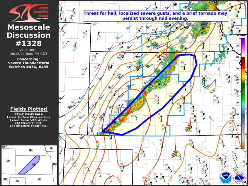
   Mesoscale Discussion 1328
   NWS Storm Prediction Center Norman OK
   0636 PM CDT Tue Jun 18 2024

   Areas affected...Southwest into central KS

   Concerning...Severe Thunderstorm Watch 434...435...

   Valid 182336Z - 190100Z

   The severe weather threat for Severe Thunderstorm Watch 434, 435
   continues.

   SUMMARY...Some threat for severe gusts, hail, and a brief tornado
   may persist into mid evening.

   DISCUSSION...A frontal band of strong to severe storms from
   southwest into central KS has been gradually shifting eastward late
   this afternoon into the early evening. While some consolidation of
   storms has occurred, multiple embedded cells persist, which will
   continue to pose a threat of isolated hail. Transient low-level
   mesocyclones continue to be noted on radar across southwest KS, and
   some threat for a brief tornado could persist within the
   vorticity-rich environment near the front. However, a general
   tendency for strengthening and expanding outflows may result in
   severe gusts becoming an increasingly prominent hazard across the
   region, as noted with a recent 60 kt gust in Russell, KS.

   A continued tendency toward backbuilding and redevelopment may
   continue through the evening across southwest KS, with a southerly
   low-level jet expected to remain focused across that region. Farther
   north, there may be some tendency for gradual weakening with time
   later this evening from north-central into northeast KS. However,
   some severe threat could persist beyond the 01Z expiration time of
   WW 434, potentially necessitating local watch extension or new watch
   issuance.

   ..Dean/Edwards.. 06/18/2024

   ...Please see www.spc.noaa.gov for graphic product...

   ATTN...WFO...TOP...ICT...GID...DDC...

   LAT...LON   37120136 38130013 38749942 39899791 39929740 39859715
               39549709 39079736 38009866 37569941 37269986 37030047
               37120136
|


 @NWSSPC