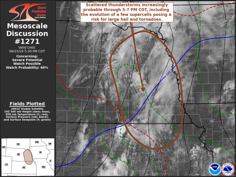
   Mesoscale Discussion 1271
   NWS Storm Prediction Center Norman OK
   0305 PM CDT Sat Jun 15 2024

   Areas affected...parts of northeastern Kansas...eastern Nebraska and
   adjacent portions of the Missouri Valley

   Concerning...Severe potential...Watch possible

   Valid 152005Z - 152230Z

   Probability of Watch Issuance...60 percent

   SUMMARY...Scattered thunderstorm development appears increasingly
   probable through 5-7 PM CDT, including the evolution of a few
   supercells accompanied by the risk for large hail and a couple of
   tornadoes.

   DISCUSSION...Modification of the boundary layer, along the western
   flank of a convectively reinforced surface front, is well underway
   across portions of northeastern Kansas into eastern Nebraska.
   Moistening within a confluent regime includes surface dew points
   rising into the lower 70s, as insolation contributes to continuing
   surface heating.  Mixed-layer CAPE appears to be increasing well in
   excess of 2000 J/kg, as mid-level inhibition gradually weakens.

   While the corridor of strongest destabilization is currently
   near/north and east of an axis (roughly) from Topeka KS through the
   Concordia KS and Grand Island NE vicinities, this is forecast to
   continue to shift slowly northward and eastward through early
   evening, in advance of weak mid-level troughing shifting toward the
   Missouri Valley (between Omaha and Sioux Falls).  As an associated
   mid-level speed maximum (40+ kt around 700 mb) noses northeast of
   the central Kansas/Nebraska border, low-level warm advection and
   enlarging clockwise-curved low-level hodographs may become focused
   across the Columbus NE through Omaha vicinity, and provide support
   for intensifying thunderstorm development by 22-00Z.  This may
   include a few supercells, with potential to produce large hail and a
   couple of tornadoes.

   ..Kerr/Gleason.. 06/15/2024

   ...Please see www.spc.noaa.gov for graphic product...

   ATTN...WFO...FSD...OAX...TOP...GID...LBF...

   LAT...LON   41009827 42049849 42739714 41709593 39819581 39249677
               39789781 41009827
|


 @NWSSPC