|
| Mesoscale Discussion 1270 |
|
< Previous MD Next MD >
|
|
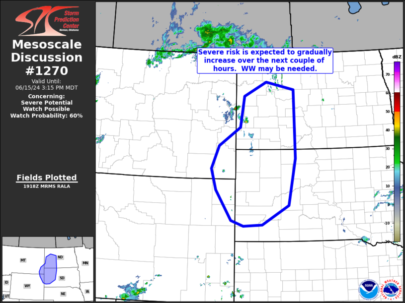
   Mesoscale Discussion 1270
   NWS Storm Prediction Center Norman OK
   0221 PM CDT Sat Jun 15 2024

   Areas affected...northeastern Wyoming...southeastern Montana...and
   into the western Dakotas

   Concerning...Severe potential...Watch possible

   Valid 151921Z - 152115Z

   Probability of Watch Issuance...60 percent

   SUMMARY...Severe potential -- mainly in the form of damaging gusts
   and large hail -- will increase with time this afternoon.  WW
   issuance may be needed.

   DISCUSSION...Latest visible satellite imagery shows TCU growth in
   the vicinity of the Black Hills (northeastern Wyoming into
   west-central South Dakota) at this time, with initial CB indicated
   near the North Dakota/Montana border.  This development is occurring
   on the western fringe of an instability gradient indicated across
   this region, as daytime heating of an axis of 60s dewpoints has
   pushed peak mixed-layer CAPE values to 2000 J/kg into the central
   Dakotas.

   As subtle short-wave troughing aloft -- indicated by a band of
   ascent spreading across Montana and central Wyoming -- continues to
   progress eastward, development of strong/locally severe storms is
   expected.  With ample flow aloft contributing to sufficient shear
   for organized convection, and with some potential for evaporative
   enhancement of downdrafts, hail/wind potential should become
   sufficient to warrant consideration of WW issuance within the next
   hour or so.

   ..Goss/Gleason.. 06/15/2024

   ...Please see www.spc.noaa.gov for graphic product...

   ATTN...WFO...ABR...BIS...UNR...BYZ...

   LAT...LON   43530285 43480368 43660424 44640492 45320513 46060480
               46640383 47630365 48080264 47830138 45640133 44150166
               43530285
|
|
Top/All Mesoscale Discussions/Forecast Products/Home
|
|


 @NWSSPC