|
| Mesoscale Discussion 1256 |
|
< Previous MD Next MD >
|
|
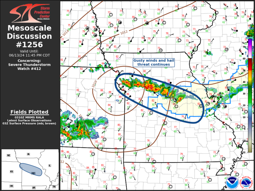
   Mesoscale Discussion 1256
   NWS Storm Prediction Center Norman OK
   1012 PM CDT Thu Jun 13 2024

   Areas affected...Missouri

   Concerning...Severe Thunderstorm Watch 412...

   Valid 140312Z - 140445Z

   The severe weather threat for Severe Thunderstorm Watch 412
   continues.

   SUMMARY...Gusty winds and hail may accompany convection as it
   propagates south late this evening.

   DISCUSSION...Western flank of early-evening MCS lingers across
   western/central MO. Latest radar data continues to suggest hail near
   golf ball size, at times, in the strongest updrafts. Locally
   damaging winds and hail will continue to be observed with this
   convection as it propagates south over the next few hours. However,
   this activity is migrating through the primary instability axis and
   nocturnal cooling may lead to increasingly elevated updrafts.

   ..Darrow.. 06/14/2024

   ...Please see www.spc.noaa.gov for graphic product...

   ATTN...WFO...LSX...SGF...EAX...

   LAT...LON   39809445 38969119 37989122 38429324 39199498 39809445
|
|
Top/All Mesoscale Discussions/Forecast Products/Home
|
|


 @NWSSPC