|
| Mesoscale Discussion 1250 |
|
< Previous MD Next MD >
|
|
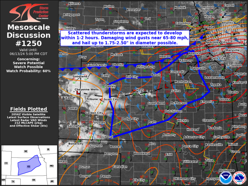
   Mesoscale Discussion 1250
   NWS Storm Prediction Center Norman OK
   0404 PM CDT Thu Jun 13 2024

   Areas affected...Central Kansas

   Concerning...Severe potential...Watch possible

   Valid 132104Z - 132200Z

   Probability of Watch Issuance...60 percent

   SUMMARY...Scattered thunderstorm development is expected across
   central KS over the next 1-2 hours. Damaging wind gusts near 65-80
   mph and large hail exceeding 1.5" in diameter may accompany a few of
   the thunderstorms.

   DISCUSSION...The most recent surface objective mesoanalyis and
   visible satellite imagery indicate CINH is eroding across central KS
   this afternoon along a prefrontal surface trough extending east to
   west. Boundary layer moisture pooling along this feature, along with
   diurnal heating leading to temperatures in the triple digits, is
   yielding ~3500 J/kg of MLCAPE amidst very steep mid-level lapse
   rates. Convective initiation is expected to occur very soon with the
   deepening cumulus across central KS, but may be delayed further
   east-northeast where a broader region of MLCINH exists. The initial
   thunderstorms that develop and remain more discrete will have an
   opportunity to produce large hail, but considering only modest deep
   layer effective shear is present, the main severe threat should be
   damaging wind gusts through early this evening. Increasing
   thunderstorm coverage over the next couple of hours may require the
   need for a WW.

   ..Barnes/Gleason.. 06/13/2024

   ...Please see www.spc.noaa.gov for graphic product...

   ATTN...WFO...OAX...TOP...ICT...GID...DDC...GLD...

   LAT...LON   38619611 38419681 37809775 37080052 38100039 38520057
               39160062 39399996 39449859 39909765 40349698 40449644
               40069623 39589618 38869570 38619611
|
|
Top/All Mesoscale Discussions/Forecast Products/Home
|
|


 @NWSSPC