|
| Mesoscale Discussion 1249 |
|
< Previous MD Next MD >
|
|
Mesoscale Discussion 1249
NWS Storm Prediction Center Norman OK
0202 PM CDT Thu Jun 13 2024
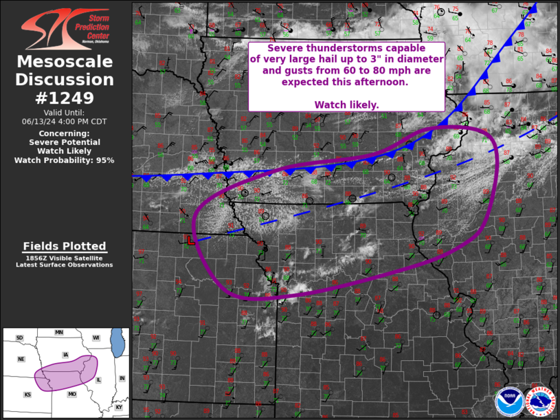
Areas affected...Northwest/West-Central IL...Southern IA...Northern
MO...Far Southeast NE...Northeast KS
Concerning...Severe potential...Watch likely
Valid 131902Z - 132100Z
Probability of Watch Issuance...95 percent
SUMMARY...Severe thunderstorms are expected to develop along and
ahead of a cold front from northwest/west-central Illinois into far
southeast Nebraska and northeast Kansas this afternoon. Very large
hail up to 3" in diameter and gusts from 60 to 80 mph are possible
and a watch will be needed to cover this severe potential.
DISCUSSION...Recent visible satellite imagery has recently shown an
increase in deepening cumulus along a pre-frontal trough from
northwest/west-central IL west-southwestward into far southeast NE
and northeast KS. Temperatures in this region have warmed into the
upper 80s/low 90s amid dewpoints in the low 70s, contributing to
very strong buoyancy. Recent mesoanalysis estimates MLCAPE currently
ranges from 2500 J/kg over IL to over 3500 J/kg across far southeast
NE and northeast KS. These values will likely increase as strong
diurnal heating persists throughout the afternoon. As observed in
recent ACARS soundings and the 18Z DVN sounding, some convective
inhibition remains in place, but continued diurnal heating should
help to erode this inhibition as well.
Robust thunderstorm development is expected to take place quickly
once inhibition erodes and convective initiation occurs. Large to
very large hail up to 3" in diameter is possible with the initial,
more cellular development. Strong buoyancy amid high cloud bases and
steep low-level lapse rates will foster strong outflow, with the
potential for this outflow to amalgamate with resultant upscale
growth into a coherent convective line. When this occurs, the
primary severe risk should shift to severe gusts (i.e. 60 to 80
mph). Veered low-level flow and a mixed boundary layer should
mitigate the tornado potential, although a low probability for a
tornado or two exists whenever there is a predominantly
supercellular mode.
..Mosier/Gleason.. 06/13/2024
...Please see www.spc.noaa.gov for graphic product...
ATTN...WFO...ILX...LSX...DVN...DMX...EAX...OAX...TOP...
LAT...LON 41828982 41308948 40268979 39839035 39449156 38959420
39019582 40349654 41159471 41469241 41899111 41828982
|
|
Top/All Mesoscale Discussions/Forecast Products/Home
|
|


 @NWSSPC