|
| Mesoscale Discussion 1085 |
|
< Previous MD Next MD >
|
|
Mesoscale Discussion 1085
NWS Storm Prediction Center Norman OK
0638 PM CDT Thu May 30 2024
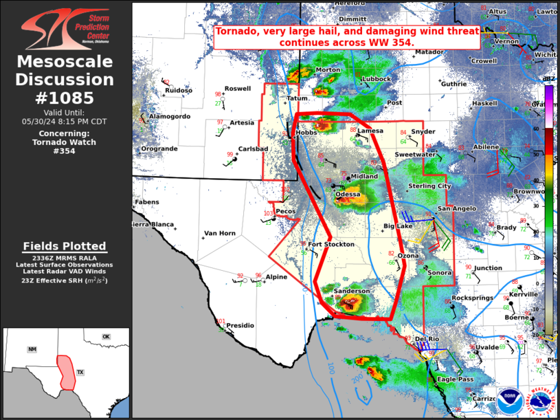
Areas affected...The Permian Basin and Trans-Pecos
Concerning...Tornado Watch 354...
Valid 302338Z - 310115Z
The severe weather threat for Tornado Watch 354 continues.
SUMMARY...A tornado, very large hail, and severe damaging wind
threat continues across the tornado watch.
DISCUSSION...Two confirmed tornadoes were recently reported very
close to MAF and briefly Denver City, in addition to very large
hail. The supercell near MAF continues to interact with the same
outflow boundary, and remains in a favorable environment for
additional tornadogensis cycles. The KMAF VAD indicated 0-1 km SRH
around 250-350 m2/s2 when the tornado occurred, and recent
mesoanalysis suggests a broad area within southeasterly surface flow
just behind the modified outflow boundary of 150-200 m2/s2 0-1 km
SRH. In addition, steep mid-level lapse rates are contributing large
CAPE within the hail growth zone as depicted in local RAP soundings.
Increasing low-level shear and moisture advection will continue
through the evening hours as a LLJ slowly intensifies. A discrete
storm mode is expected to continue (deep layer effective shear 55-60
kt normal to forcing) before mergers occur late this evening.
..Barnes.. 05/30/2024
...Please see www.spc.noaa.gov for graphic product...
ATTN...WFO...EWX...SJT...LUB...MAF...
LAT...LON 29800233 30020259 30360271 31090242 32320313 32770316
33070308 33100269 33070205 32840167 32290142 31700128
31030111 30620104 30030120 29750130 29770185 29800233
|
|
Top/All Mesoscale Discussions/Forecast Products/Home
|
|


 @NWSSPC