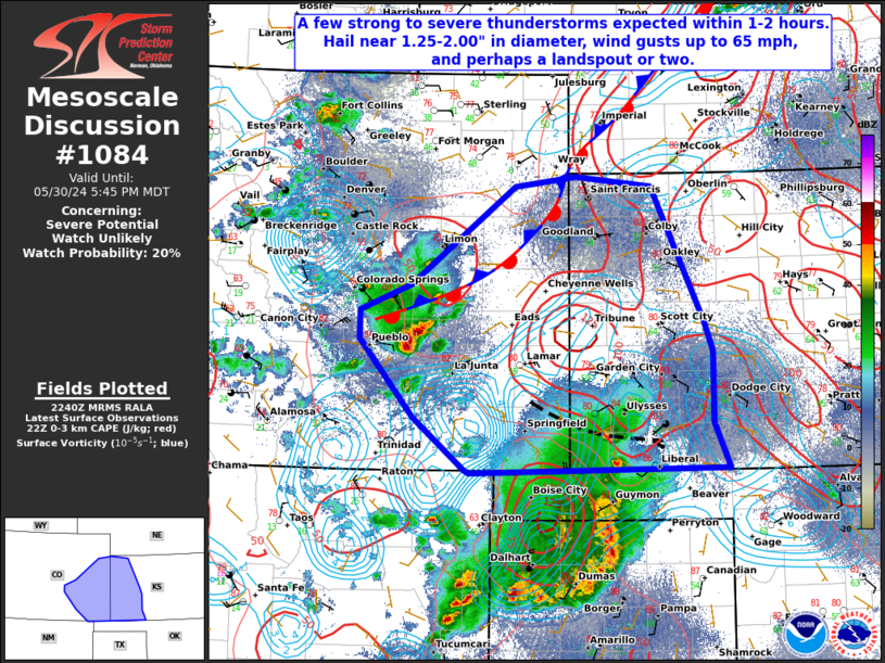
   Mesoscale Discussion 1084
   NWS Storm Prediction Center Norman OK
   0541 PM CDT Thu May 30 2024

   Areas affected...The High Plains of southeast Colorado and
   southwestern Kansas

   Concerning...Severe potential...Watch unlikely

   Valid 302241Z - 302345Z

   Probability of Watch Issuance...20 percent

   SUMMARY...A few strong to severe storms, including one or two
   transient supercells, may develop over the next 1-2 hours across
   portions of southeast CO and southwest KS. Large hail near
   1.25-2.00" in diameter, wind gusts up to 65 mph, and a landspout or
   two will be possible.

   DISCUSSION...A couple of relatively robust thunderstorms have
   developed this afternoon in the lee of the Rockies near PUB, and
   along an outflow boundary and surface low intersection across far
   southwest KS. Additional towering CU are also beginning to develop
   east of PUB. Daytime heating and cooler mid-level temperatures
   aloft/steep mid-level lapse, combined with surface dewpoints in the
   upper 50s to low 60s, have contributed to moderate MLCAPE around
   1500-2500 J/kg. Although weaker mid to upper-level flow is only
   yielding around 25-30 kt of deep layer effective shear, a slow
   increase is anticipated through this evening.

   This environment could support transient supercells with a threat of
   large hail and localized severe wind gusts. In addition, enhanced
   surface vorticity combined with modest low-level cape may present an
   opportunity for a landspout tornado or two. However, limited
   thunderstorm coverage may preclude the need for a WW at this time.

   ..Barnes/Hart.. 05/30/2024

   ...Please see www.spc.noaa.gov for graphic product...

   ATTN...WFO...DDC...GLD...AMA...PUB...BOU...ABQ...

   LAT...LON   36990338 37520403 38310472 38610472 38870408 39870274
               39970195 39870098 38500031 38200021 37480020 37020001
               36960332 36990338
|


 @NWSSPC