Mesoscale Discussion 1046
NWS Storm Prediction Center Norman OK
0132 PM CDT Tue May 28 2024
Areas affected...portions of southwestern Texas
Concerning...Severe potential...Watch likely
Valid 281832Z - 282000Z
Probability of Watch Issuance...80 percent
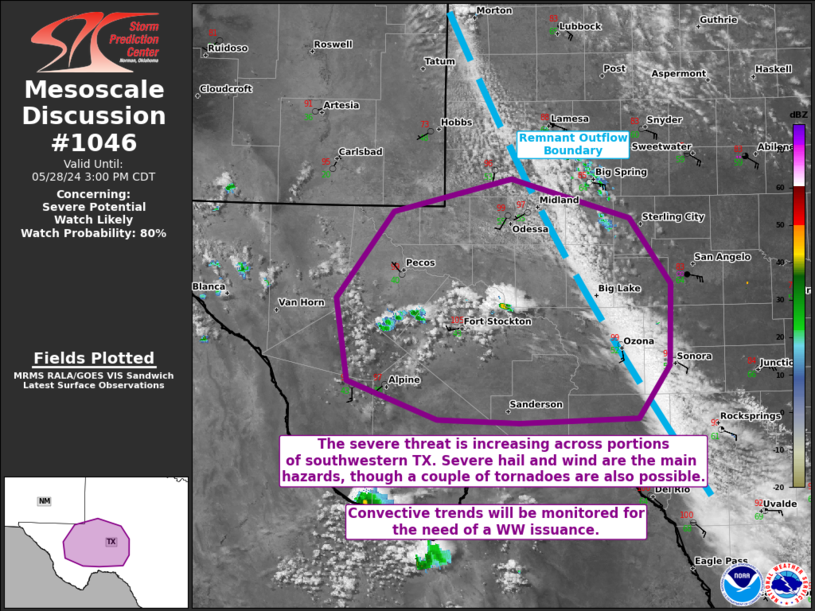
SUMMARY...The severe threat should increase through the afternoon,
with a possibly more rapid uptick in storm intensification for cells
interacting with an outflow boundary. These storms will initially
have a damaging gust/hail threat, though a tornado cannot be ruled
out with storms interacting with the boundary. Convective trends are
being monitored for the need of a WW issuance.
DISCUSSION...Rapidly deepening CU have developed over the Trans
Pecos region in Texas, atop a deep and well-mixed boundary layer.
Based on the latest RAP forecast soundings, the boundary layer
extends to somewhere between 600-500 mb, so convective initiation
will result in high-based thunderstorms. Given the 9-10+ C/km
low-level lapse rates in the boundary layer, any of the more intense
storms that form could produce dry downbursts, and a dry microburst
capable of 65+ kt gusts cannot be completely ruled out. As the
storms progress eastward, they will move into an increasingly
moister and more unstable airmass. At the same time, they will
interact with a southwestward-moving outflow boundary generated by
an earlier MCS. Enhanced lift along this boundary may support an
uptick in thunderstorm intensity for any updrafts crossing this
boundary. Elongated hodographs and 40+ kts of effective bulk shear
suggest that multicells and splitting supercells will be the main
modes of convection, with large hail possible. Some stones may
exceed 2 inches in diameter.
It is unclear precisely when an uptick in greater severe coverage
will occur. Nonetheless, the CAPE/shear parameter space and synoptic
environment suggest that an appreciable severe threat will unfold at
some point this afternoon, when a WW issuance will ultimately be
necessary.
..Squitieri/Hart.. 05/28/2024
...Please see www.spc.noaa.gov for graphic product...
ATTN...WFO...EWX...SJT...MAF...
LAT...LON 31160420 31940359 32250235 31890110 31280067 30550068
30070102 30030226 30050313 30400407 31160420
|


 @NWSSPC