|
| Mesoscale Discussion 1045 |
|
< Previous MD Next MD >
|
|
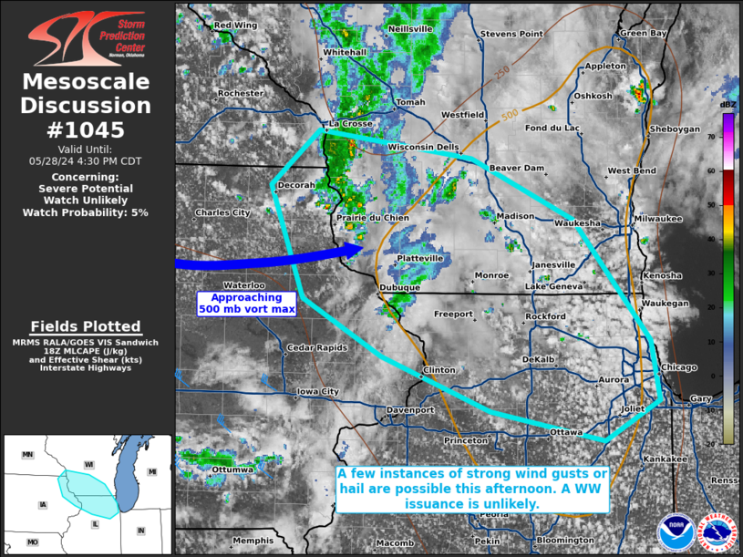
   Mesoscale Discussion 1045
   NWS Storm Prediction Center Norman OK
   0102 PM CDT Tue May 28 2024

   Areas affected...portions of far southern Wisconsin into northern IL

   Concerning...Severe potential...Watch unlikely

   Valid 281802Z - 282130Z

   Probability of Watch Issuance...5 percent

   SUMMARY...A gradual increase in thunderstorm coverage and intensity
   is expected throughout the afternoon. Scattered strong storms may
   occasionally produce gusty winds and hail. The severe threat should
   remain isolated, and a WW issuance is not expected.

   DISCUSSION...Visible satellite shows a gradually deepening CU field
   over southern WI/northern IL, which precedes a 500 mb vort max that
   is approaching from eastern IA. As the vort max progresses eastward,
   the combination of increasing deep-layer ascent and diurnal heating
   will support an increase in thunderstorm development through the
   afternoon. These storms will develop in an environment characterized
   by 7+ C/km low and mid-level lapse rates, but mediocre deep-layer
   effective shear and only around 500 J/kg MLCAPE. As such, storms may
   produce a couple instances of strong, gusty winds or hail. While a
   few instances of severe hail/wind cannot be ruled out, the severe
   threat is expected to remain sparse, and a WW issuance is not
   anticipated.

   ..Squitieri/Hart.. 05/28/2024

   ...Please see www.spc.noaa.gov for graphic product...

   ATTN...WFO...LOT...MKX...DVN...ARX...

   LAT...LON   43369183 43809131 43588965 43098854 42128773 41648764
               41328822 41568944 42009061 42459147 43369183
|
|
Top/All Mesoscale Discussions/Forecast Products/Home
|
|


 @NWSSPC