|
| Mesoscale Discussion 919 |
|
< Previous MD Next MD >
|
|
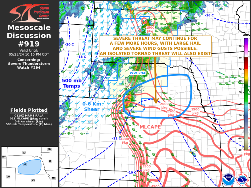
   Mesoscale Discussion 0919
   NWS Storm Prediction Center Norman OK
   0820 PM CDT Thu May 23 2024

   Areas affected...Nebraska

   Concerning...Severe Thunderstorm Watch 294...

   Valid 240120Z - 240315Z

   The severe weather threat for Severe Thunderstorm Watch 294
   continues.

   SUMMARY...A severe threat is expected to continue for several more
   hours across southwestern and south-central Nebraska, and may affect
   parts of central and eastern Nebraska late this evening. Large hail,
   severe wind gusts and an isolated tornado threat will be possible.
   New weather watch issuance will be needed to the east of the ongoing
   watch.

   DISCUSSION...The latest hi-resolution radar imagery from Hasting, NE
   shows a short intense line segment just to the west of North Platte.
   This storm complex is located on the northwestern edge of a strongly
   unstable airmass, where surface dewpoints are in the lower 60s F and
   the RAP is estimating MLCAPE in the 2000 to 3000 J/kg range. The
   line will continue to move east-southeastward along the northern
   edge of this airmass into south-central Nebraska over the next few
   hours. RAP forecast soundings in south-central Nebraska have 0-6 km
   shear around 40 knots with 700-500 mb lapse rates near 7.5 C/km.
   This should continue to support supercell development, with a
   potential for large hail. However, linear mode may be favored as the
   line of strong to severe storms expands as it moves eastward into
   central and eastern Nebraska. Severe wind gusts are expected with
   the more intense parts of the line.

   ..Broyles/Thompson.. 05/24/2024

   ...Please see www.spc.noaa.gov for graphic product...

   ATTN...WFO...FSD...OAX...GID...LBF...GLD...

   LAT...LON   40000031 39989876 40039776 40289715 40829667 41739656
               42279676 42379713 42349803 42179926 41380131 40550150
               40160118 40000031
|
|
Top/All Mesoscale Discussions/Forecast Products/Home
|
|


 @NWSSPC