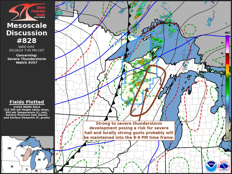
   Mesoscale Discussion 0828
   NWS Storm Prediction Center Norman OK
   0546 PM CDT Sat May 18 2024

   Areas affected...parts of central/northeastern Wisconsin into
   adjacent portions of Upper Michigan

   Concerning...Severe Thunderstorm Watch 257...

   Valid 182246Z - 190045Z

   The severe weather threat for Severe Thunderstorm Watch 257
   continues.

   SUMMARY...Strong to severe thunderstorm development, including a few
   supercells posing a risk for severe hail and wind, probably will be
   maintained while spreading eastward across the region through around
   8-9 PM CDT.

   DISCUSSION...Multiple discrete thunderstorms, including evolving
   supercells, are ongoing, emanating from a zone of stronger
   pre-frontal confluence across west central Wisconsin into the
   western Upper Peninsula of Michigan vicinity.  Boundary-layer
   instability appears maximized along this corridor with mixed-layer
   CAPE on the order of 1000-1500 J/kg and renewed convective
   initiation remains possible another couple of hours as this zone
   shifts slowly eastward.

   Embedded within strongly sheared, 30-40 kt southwesterly deep-layer
   mean flow, storms have tended to propagate northeastward and
   eastward away from the initiating zone.  Aided by the strong shear,
   these storms may continue to pose a risk for severe hail and locally
   strong gusts while spreading toward the Iron Mountain, Green Bay and
   Oshkosh vicinities through 00-01Z.  While forecast soundings exhibit
   low-level hodographs potentially conducive to a a risk for
   tornadoes, it still appears this risk will be limited by sizable
   boundary-layer temperature/dew point spreads.

   ..Kerr.. 05/18/2024

   ...Please see www.spc.noaa.gov for graphic product...

   ATTN...WFO...MQT...GRB...MKX...ARX...

   LAT...LON   45868902 46428861 46008744 44678817 43778901 43609009
               44288998 45358935 45868902
|


 @NWSSPC