|
| Mesoscale Discussion 208 |
|
< Previous MD Next MD >
|
|
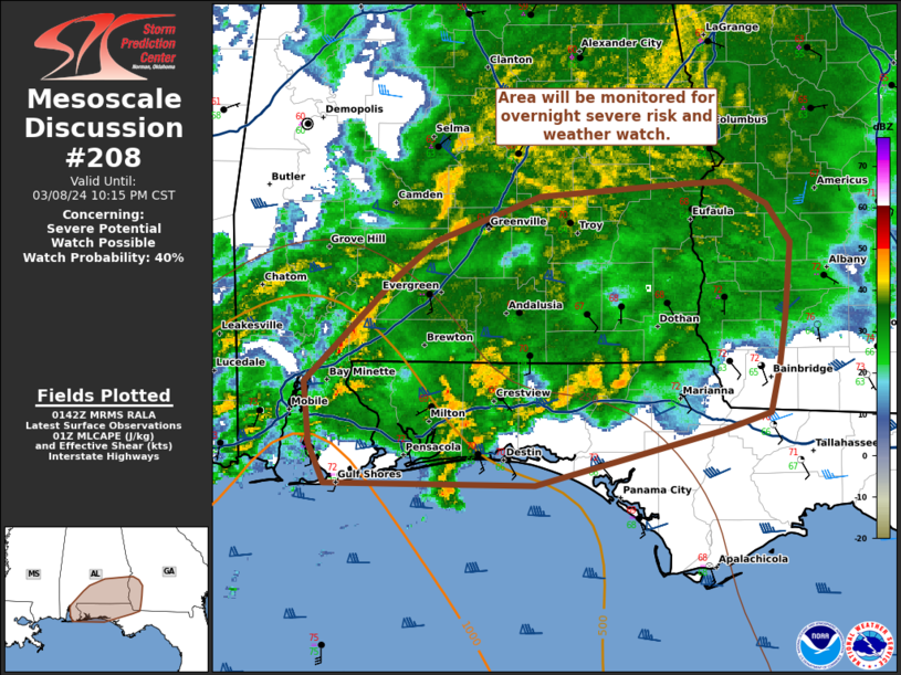
   Mesoscale Discussion 0208
   NWS Storm Prediction Center Norman OK
   0744 PM CST Fri Mar 08 2024

   Areas affected...southeastern Alabama into southwestern Georgia and
   the eastern Florida Panhandle

   Concerning...Severe potential...Watch possible

   Valid 090144Z - 090415Z

   Probability of Watch Issuance...40 percent

   SUMMARY...The area across southeastern Alabama into southwestern
   Georgia and the eastern Florida Panhandle will be monitored for
   potential severe risk later this evening into the early morning.

   DISCUSSION...A large area of ongoing convection along a stationary
   front draped across the Gulf northward into portions of southern
   Mississippi and southern/central Alabama has struggled to organize
   this evening given the poor thermodynamic profiles as the warm
   sector has struggled to advance inland. Dew points are largely in
   the mid -60s along the immediate coast of Florida into southern
   Alabama/Georgia. Shear profiles have remained supportive of more
   organized convection but forcing along the stationary boundary in
   tandem with the main upper level wave has led to multi-cell clusters
   with transient embedded rotation.

   Through the rest of the evening/early morning, this area of
   convection is expected to move east and northeast. CAMs continue to
   indicate the possibility of addition thunderstorm development
   overnight, with potential for more discrete supercell development as
   better moisture works inland. Given the favorable shear profiles,
   with effective SRH around 200-300 m2/s2, it is possible that an
   isolated tornado risk could persist into the early morning. Given
   uncertainty on thermodynamics and redevelopment/storm mode, this
   area will need to be monitored for watch potential in the coming
   hours.

   ..Thornton/Thompson.. 03/09/2024

   ...Please see www.spc.noaa.gov for graphic product...

   ATTN...WFO...FFC...TAE...BMX...MOB...

   LAT...LON   30578491 30238627 30248779 30488789 30868793 31518729
               31758698 32038623 32088559 32108514 32118486 31988458
               31748441 31288445 30938450 30688457 30578491
|
|
Top/All Mesoscale Discussions/Forecast Products/Home
|
|


 @NWSSPC