|
| Mesoscale Discussion 207 |
|
< Previous MD Next MD >
|
|
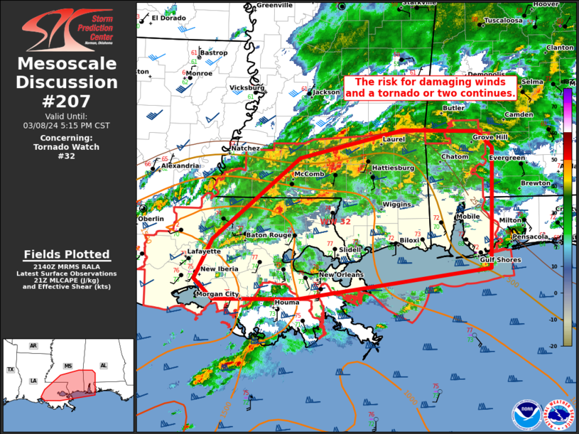
   Mesoscale Discussion 0207
   NWS Storm Prediction Center Norman OK
   0342 PM CST Fri Mar 08 2024

   Areas affected...portions of eastern Louisiana...southern
   Mississippi...and southwest Alabama

   Concerning...Tornado Watch 32...

   Valid 082142Z - 082315Z

   The severe weather threat for Tornado Watch 32 continues.

   SUMMARY...The environment remains broadly favorable for damaging
   gusts and a tornado or two this afternoon across WW032.

   DISCUSSION...Across Tornado Watch 32, widespread convection is
   ongoing along a southward surging outflow across parts of southern
   MS and eastern LA. Transient supercell structures and bowing
   segments have been noted with this activity over the past several
   hours. The environment remains broadly favorable for damaging gusts
   of 50-60 mph and/or a brief tornado, given ~1000 J/kg of MLCAPE and
   50-60+ kt of effective shear. However, the surging nature of outflow
   and numerous storm interactions may continue to limit greater severe
   potential within this broader cluster.

   Farther south, more discrete convection is ongoing across
   southeastern LA and far southern MS. An impressive kinematic
   parameter space with strong low-level shear (0-1 km SRH of 300-400
   m2/s2) remains in place along with minimal inhibition. WOFS and
   other hi-res guidance continue to suggest a favorable environment
   for damaging gusts of 55-65 mph and a tornado, should better
   organized supercells emerge. With this in mind, the severe risk will
   likely continue as storms track east/northeastward the warm front
   over parts of southern AL.

   ..Lyons.. 03/08/2024

   ...Please see www.spc.noaa.gov for graphic product...

   ATTN...WFO...MOB...JAN...LIX...LCH...

   LAT...LON   29699036 29689161 29949189 30459163 31509034 31878881
               31858770 31638746 30788748 30088750 29699036
|
|
Top/All Mesoscale Discussions/Forecast Products/Home
|
|


 @NWSSPC