|
| Mesoscale Discussion 1608 |
|
< Previous MD Next MD >
|
|
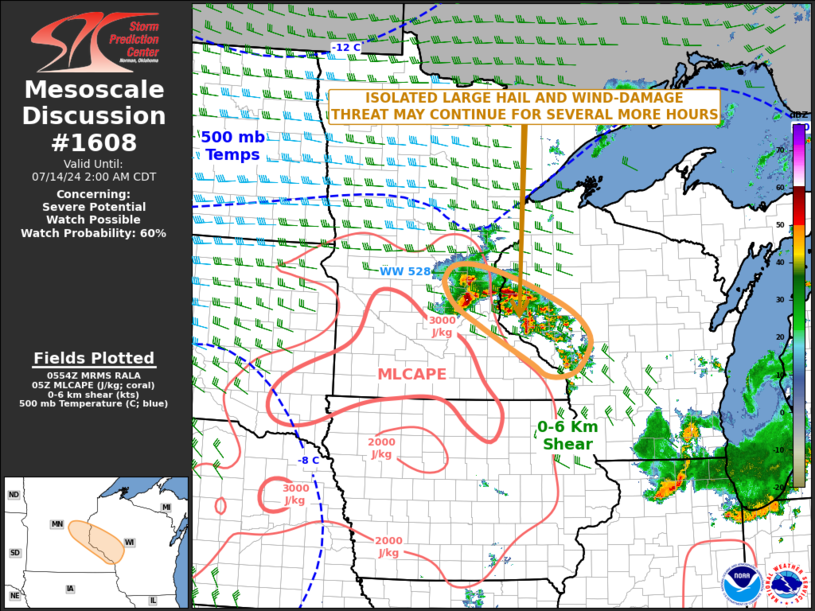
   Mesoscale Discussion 1608
   NWS Storm Prediction Center Norman OK
   1256 AM CDT Sun Jul 14 2024

   Areas affected...Southeast Minnesota...Western Wisconsin

   Concerning...Severe potential...Watch possible

   Valid 140556Z - 140700Z

   Probability of Watch Issuance...60 percent

   SUMMARY...An isolated large hail and wind damage threat may continue
   for several more hours across parts of southeast Minnesota into
   western Wisconsin. A new weather watch to the southeast of WW 528
   will likely need to be considered.

   DISCUSSION...The latest hi-resolution radar imagery from Minneapolis
   shows a cluster of strong to severe storms over southeast Minnesota
   and western Wisconsin. Most of the storms are multicells, although a
   supercell is ongoing just to the northwest of Minneapolis. These
   storms are located along an gradient of moisture and instability
   that is oriented from north-northwest to south-southeast in the
   vicinity of Minneapolis. The storms are likely being supported by a
   minor shortwave trough that is moving through the upper Mississippi
   Valley. In addition, a maximum in low-level flow is analyzed just to
   the west of this cluster. The latest WSR-88D VWP at Minneapolis has
   0-6 km shear near 50 knots with about 20 knots of speed shear from
   the surface to about 4 km AGL. This, combined with the moderate
   instability, should continue to support a severe threat over the
   next several hours. Isolated large hail and wind damage will be the
   primary threats.

   ..Broyles/Edwards.. 07/14/2024

   ...Please see www.spc.noaa.gov for graphic product...

   ATTN...WFO...ARX...MPX...

   LAT...LON   45299197 45559277 45679338 45659381 45489399 45339400
               45019376 44699321 44419267 44089202 43909172 43869138
               43959104 44219080 44529072 44909111 45299197
|
|
Top/All Mesoscale Discussions/Forecast Products/Home
|
|


 @NWSSPC