|
| Mesoscale Discussion 1606 |
|
< Previous MD Next MD >
|
|
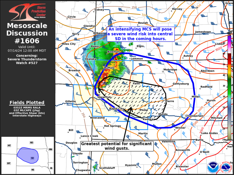
   Mesoscale Discussion 1606
   NWS Storm Prediction Center Norman OK
   1054 PM CDT Sat Jul 13 2024

   Areas affected...Northwest to central South Dakota

   Concerning...Severe Thunderstorm Watch 527...

   Valid 140354Z - 140600Z

   The severe weather threat for Severe Thunderstorm Watch 527
   continues.

   SUMMARY...An intensifying MCS is expected to move into central SD in
   the coming hours and will pose a severe wind threat based on recent
   observed trends and latest forecast guidance.

   DISCUSSION...Upscale growth from a cluster of semi-discrete cells
   into an organizing MCS is well underway across far southwest ND and
   northwest SD. GOES IR imagery has shown a steady decrease in
   cloud-top temperatures over the past 30 minutes, signifying an
   intensification trend. Multiple severe wind reports, including an 87
   mph gust in northwest SD, over the past hour or so validate this
   trend. The developing MCS should continue to organize and intensify
   as it migrates in a more buoyant air mass downstream across SD
   (characterized by 1500-2000 J/kg MLCAPE). While severe gusts appear
   possible along the length of the line, the potential for severe
   winds, including significant gusts (75+ mph), appears greatest ahead
   of a surging section of the line over Butte county, SD that is
   associated with the remnants of a decaying mesocyclone. Latest HRRR
   solutions appear to have initialized recent observed trends well and
   suggest the greatest severe/significant wind threat will be
   associated with this section of the line as it moves southeast into
   central SD. Downstream watch issuance will likely be needed within
   an hour to address this concern.

   ..Moore.. 07/14/2024

   ...Please see www.spc.noaa.gov for graphic product...

   ATTN...WFO...FSD...ABR...BIS...UNR...

   LAT...LON   44670392 44970396 45440365 45860328 46110295 46200264
               46200219 45799960 45539910 45099886 44599878 44069889
               43679935 43460006 43450070 43640140 43900236 44670392
|
|
Top/All Mesoscale Discussions/Forecast Products/Home
|
|


 @NWSSPC