|
| Mesoscale Discussion 1569 |
|
< Previous MD Next MD >
|
|
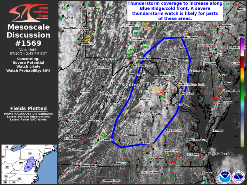
   Mesoscale Discussion 1569
   NWS Storm Prediction Center Norman OK
   1152 AM CDT Wed Jul 10 2024

   Areas affected...South-central Pennsylvania...central
   Maryland...northern/central Virginia

   Concerning...Severe potential...Watch likely

   Valid 101652Z - 101845Z

   Probability of Watch Issuance...80 percent

   SUMMARY...Widely scattered to scattered storms will pose a threat of
   mainly damaging winds and a tornado or two. A severe thunderstorm
   watch is likely for parts of Virginia into south-central
   Pennsylvania.

   DISCUSSION...A very moist airmass is in place across the
   Mid-Atlantic. Dewpoints are in generally in the low/mid 70s F.
   Morning observed soundings from the region suggest even limited
   heating would lead to surface-based destabilization. Current surface
   observations already show temperatures in the upper 80s to low 90s F
   which should be sufficient. Visible satellite shows a few updrafts
   beginning to deepen within the Blue Ridge. Modest mid-level ascent
   will occur this afternoon, particularly for northern Virginia into
   south-central Pennsylvania. Coupled with the approach of a cold
   front from the west, widely scattered to scattered storms are
   expected. The greatest potential for supercells will be in
   south-central Pennsylvania into central Maryland/northern Virginia
   where effective shear will be 35-40 kts. Farther south, multicells
   will be the predominant mode. Damaging wind gusts will be the
   primary hazard this afternoon. A low-end tornado threat will also be
   present for northern Virginia into south-central Pennsylvania, where
   low-level shear will be slightly greater nearer to the surface low.
   This is also supported by KCCX/KLWX VAD data. A severe thunderstorm
   watch is likely for parts of the Mid-Atlantic, though uncertainty is
   greater with southern extent.

   ..Wendt/Guyer.. 07/10/2024

   ...Please see www.spc.noaa.gov for graphic product...

   ATTN...WFO...AKQ...CTP...LWX...RNK...

   LAT...LON   38097711 37257791 37107913 37297948 37917931 38537884
               39837828 40317753 40327686 39697656 38977666 38097711
|
|
Top/All Mesoscale Discussions/Forecast Products/Home
|
|


 @NWSSPC