|
| Mesoscale Discussion 1558 |
|
< Previous MD Next MD >
|
|
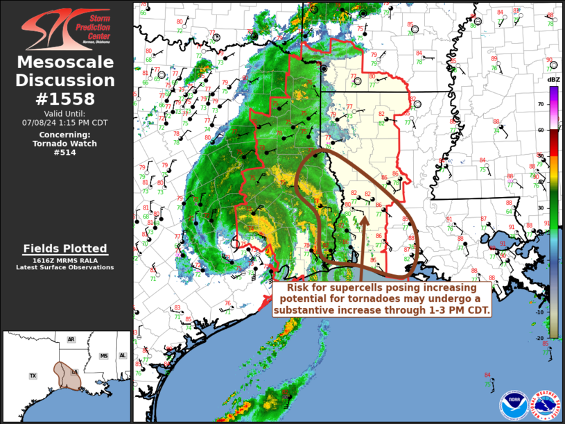
   Mesoscale Discussion 1558
   NWS Storm Prediction Center Norman OK
   1119 AM CDT Mon Jul 08 2024

   Areas affected...parts of southeastern Texas and southwestern/west
   central Louisiana

   Concerning...Tornado Watch 514...

   Valid 081619Z - 081815Z

   The severe weather threat for Tornado Watch 514 continues.

   SUMMARY...Within and ahead of outer bands of Beryl, the risk for
   supercells with potential to produce tornadoes may undergo a
   substantive increase through 1-3 PM CDT.

   DISCUSSION...The low-level circulation center of Beryl is
   progressing slowly northward, near/west through north of the Houston
   Intercontinental vicinity.  VWP data from KGHX indicates that
   low-level wind fields have veered to a south-southwesterly component
   with hodographs becoming more linear, and downward mixing of drier
   air is lowering surface dew points into the lower 70s F across much
   of the Greater Houston area.

   On the eastern to northeastern periphery of Beryl, surface dew
   points continue to rise through the upper 70s F, in the presence of
   enlarging clockwise-curved low-level hodographs closer to the Sabine
   River and into southwestern and west central Louisiana.  Coupled
   with further boundary-layer destabilization, aided by daytime
   heating beneath the eastern periphery of the mid-level warm core,
   the potential for tornadoes may begin to substantively increase
   through 18-20Z.  This may include with evolving supercells within
   the north-northeastward pivoting outer bands, and perhaps discretely
   to their north and east.

   ..Kerr.. 07/08/2024

   ...Please see www.spc.noaa.gov for graphic product...

   ATTN...WFO...LCH...SHV...

   LAT...LON   31769433 31849367 30649208 29619213 29799322 29949397
               30699407 31199455 31769433
|
|
Top/All Mesoscale Discussions/Forecast Products/Home
|
|


 @NWSSPC