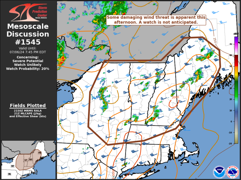
   Mesoscale Discussion 1545
   NWS Storm Prediction Center Norman OK
   0452 PM CDT Sat Jul 06 2024

   Areas affected...the Adirondacks into Parts of northern New England

   Concerning...Severe potential...Watch unlikely

   Valid 062152Z - 062345Z

   Probability of Watch Issuance...20 percent

   SUMMARY...Some damaging wind threat is apparent this afternoon
   across parts of the Adirondacks into northern new England. A watch
   is not anticipated.

   DISCUSSION...Thunderstorms, some of which are displaying supercell
   characteristics on radar, are ongoing this afternoon across parts of
   the Adirondacks into northern New England. These storms are situated
   in a fairly healthy mid- and upper-level jet for July, with 50-60
   kts of effective bulk shear. Thermodynamically, the environment is
   fairly moist, with 1.6-1.8" of precipitable water, 1000-1500 J/kg of
   MLCAPE, and pockets of 7-8 C/km low-level lapse rates. All of this
   suggests the continued potential for supercells with damaging gusts
   due to large water loading. Some clustering may occur with time, and
   this may increase the damaging wind threat with storms. However, a
   watch is not anticipated at this time due to the expected sparse
   coverage of damaging gusts.

   ..Supinie/Hart.. 07/06/2024

   ...Please see www.spc.noaa.gov for graphic product...

   ATTN...WFO...CAR...GYX...BOX...BTV...ALY...BGM...BUF...

   LAT...LON   43907535 45067466 45107175 45917057 45926959 45416874
               44806874 44606888 43916941 42607105 42157262 41997439
               42627538 43907535
|


 @NWSSPC