|
| Mesoscale Discussion 1314 |
|
< Previous MD Next MD >
|
|
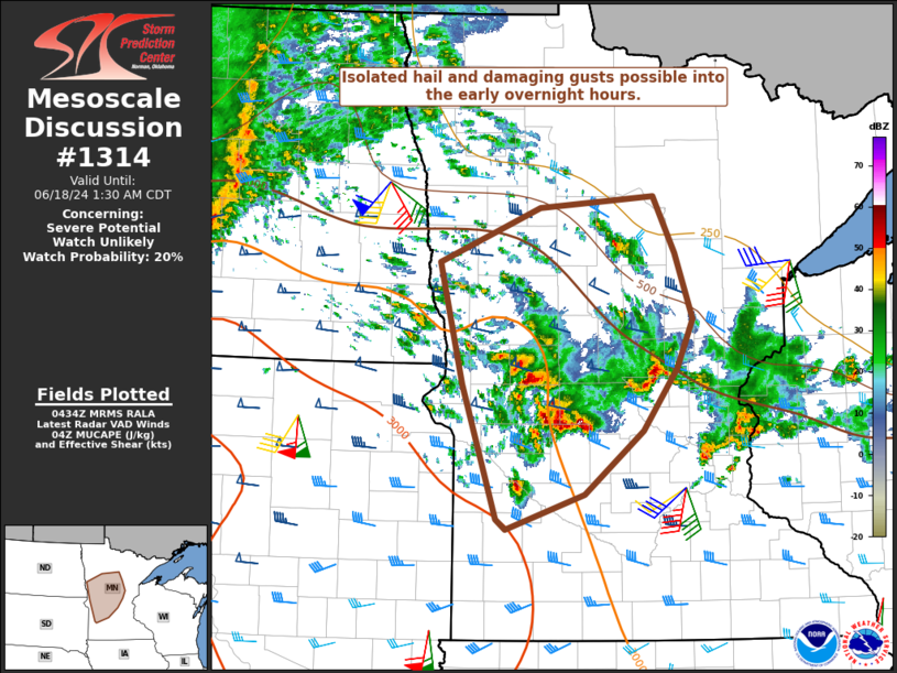
   Mesoscale Discussion 1314
   NWS Storm Prediction Center Norman OK
   1136 PM CDT Mon Jun 17 2024

   Areas affected...Parts of western/central MN

   Concerning...Severe potential...Watch unlikely

   Valid 180436Z - 180630Z

   Probability of Watch Issuance...20 percent

   SUMMARY...Isolated hail and damaging gusts are possible into the
   early overnight hours.

   DISCUSSION...A cluster of strong storms is ongoing late this evening
   across parts of southwest/west-central MN, within a warm-advection
   regime driven by an intense (50+ kt as sampled by the KFSD VWP)
   low-level jet. This region is along the northeastern periphery of
   the EML, with MUCAPE generally in the 1000-2000 J/kg range.
   Effective shear of 40+ kt may continue to support occasional
   elevated supercells into the early overnight hours, accompanied by a
   threat for isolated hail and perhaps strong/damaging gusts.

   ..Dean/Edwards.. 06/18/2024

   ...Please see www.spc.noaa.gov for graphic product...

   ATTN...WFO...DLH...MPX...FGF...FSD...ABR...

   LAT...LON   44579592 45759636 46829665 47319538 47419393 46919367
               46329344 45909364 45349408 44799481 44479581 44579592
|
|
Top/All Mesoscale Discussions/Forecast Products/Home
|
|


 @NWSSPC