|
| Mesoscale Discussion 1310 |
|
< Previous MD Next MD >
|
|
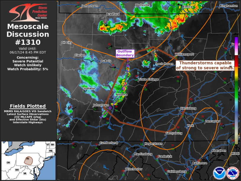
   Mesoscale Discussion 1310
   NWS Storm Prediction Center Norman OK
   0650 PM CDT Mon Jun 17 2024

   Areas affected...central Pennsylvania

   Concerning...Severe potential...Watch unlikely

   Valid 172350Z - 180045Z

   Probability of Watch Issuance...5 percent

   SUMMARY...Thunderstorms with the potential for strong to severe wind
   will persist across central Pennsylvania.

   DISCUSSION...A line of thunderstorms has developed along a remnant
   outflow boundary across central PA. Ahead of this line of storms,
   temperatures are in the mid 80s to 90s with mid to upper 60s
   dewpoints. The downstream air mass is further characterized by
   MLCAPE around 500-1000 J/kg and steep low-level lapse rates. Weaker
   mid-level lapse rates are noted along with generally weak flow
   aloft. Nonetheless, this environment will support instances of
   strong to severe wind over the next couple of hours, should this
   line maintain intensity and progress eastward.

   ..Thornton/Edwards.. 06/17/2024

   ...Please see www.spc.noaa.gov for graphic product...

   ATTN...WFO...CTP...

   LAT...LON   40317865 41137820 41337785 41417750 41197696 40897668
               40717665 40377671 40147684 39947701 39877719 39927757
               40057828 40317865
|
|
Top/All Mesoscale Discussions/Forecast Products/Home
|
|


 @NWSSPC