|
| Mesoscale Discussion 1297 |
|
< Previous MD Next MD >
|
|
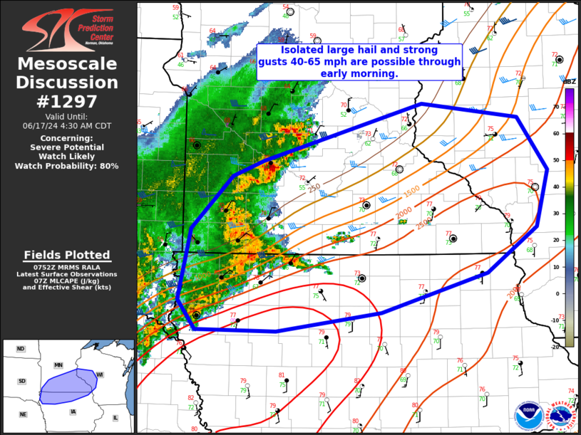
   Mesoscale Discussion 1297
   NWS Storm Prediction Center Norman OK
   0255 AM CDT Mon Jun 17 2024

   Areas affected...southern MN into northern IA and west-central WI

   Concerning...Severe potential...Watch likely

   Valid 170755Z - 170930Z

   Probability of Watch Issuance...80 percent

   SUMMARY...Isolated large hail and strong/severe wind gusts 50-65 mph
   possible through early morning. A severe thunderstorm watch is being
   considered.

   DISCUSSION...A cluster of thunderstorms has become better organized
   near the southwest MN/northwest IA border over the past hour. This
   activity is occurring closer to a surface boundary and on the nose
   of a 35 kt southwesterly low-level jet. Sufficient instability,
   steep midlevel lapse rates, and effective shear magnitudes greater
   than 35 kt will support strong to severe thunderstorms into early
   morning. A severe thunderstorm watch will likely be needed soon to
   address this increasing severe risk.

   ..Leitman/Guyer.. 06/17/2024

   ...Please see www.spc.noaa.gov for graphic product...

   ATTN...WFO...ARX...MPX...DMX...FSD...

   LAT...LON   42969651 43779631 44399567 44579518 45239266 45069112
               44449065 43799085 43289164 42839330 42609495 42619622
               42969651
|
|
Top/All Mesoscale Discussions/Forecast Products/Home
|
|


 @NWSSPC