|
| Mesoscale Discussion 1296 |
|
< Previous MD Next MD >
|
|
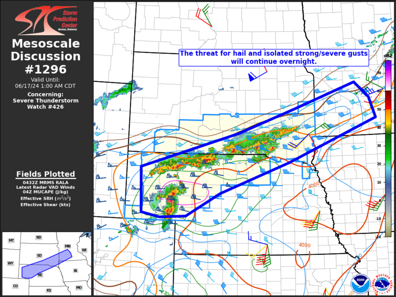
   Mesoscale Discussion 1296
   NWS Storm Prediction Center Norman OK
   1134 PM CDT Sun Jun 16 2024

   Areas affected...Western/northern NE...south-central/southeast
   SD...southwest MN...extreme northwest IA

   Concerning...Severe Thunderstorm Watch 426...

   Valid 170434Z - 170600Z

   The severe weather threat for Severe Thunderstorm Watch 426
   continues.

   SUMMARY...The threat for hail and perhaps isolated strong/severe
   gusts will continue overnight.

   DISCUSSION...A band of elevated convection that earlier erupted
   across northern NE/southern SD has evolved into an elongated storm
   cluster with occasional embedded elevated supercells. Some recent
   intensification has also been noted with a storm cluster moving into
   the southeast part of the NE Panhandle from northeast CO. Moderate
   to strong elevated buoyancy and sufficient deep-layer shear will
   support occasionally organized storms into the overnight hours. A
   strong low-level jet will continue to support rather widespread
   storm coverage, with a tendency toward a cluster and perhaps
   eventually a linear mode. This mode evolution may not be ideal for a
   more organized hail threat, but very steep midlevel lapse rates will
   result in occasional large-hail potential with the stronger embedded
   cells. Isolated strong to severe gusts will also be possible,
   especially if organized upscale growth occurs.

   Some severe threat may spread into southern MN and far northwest IA
   with time, and eventual downstream watch issuance is possible if
   observational trends support maintenance of an organized
   severe-thunderstorm threat.

   ..Dean/Smith.. 06/17/2024

   ...Please see www.spc.noaa.gov for graphic product...

   ATTN...WFO...MPX...FSD...OAX...ABR...LBF...UNR...CYS...

   LAT...LON   42570349 43619957 44339729 45089478 44629420 44009395
               42749751 41830029 41140165 41080267 41210340 42570349
|
|
Top/All Mesoscale Discussions/Forecast Products/Home
|
|


 @NWSSPC