|
| Mesoscale Discussion 1290 |
|
< Previous MD Next MD >
|
|
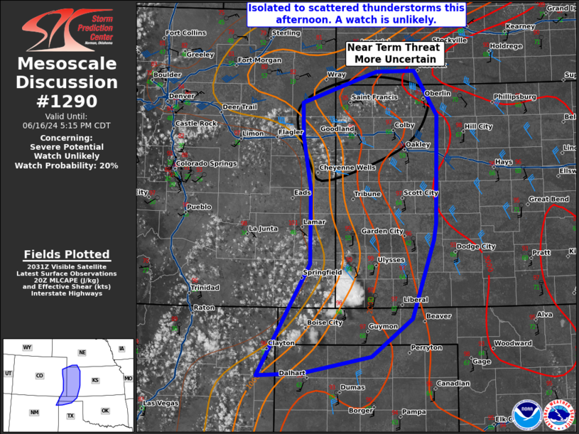
   Mesoscale Discussion 1290
   NWS Storm Prediction Center Norman OK
   0339 PM CDT Sun Jun 16 2024

   Areas affected...the OK Panhandle...northern Texas
   Panhandle...western Kansas and far eastern Colorado

   Concerning...Severe potential...Watch unlikely

   Valid 162039Z - 162215Z

   Probability of Watch Issuance...20 percent

   SUMMARY...There is a threat for isolated to scattered thunderstorms
   this afternoon capable of large hail or severe wind gusts.

   DISCUSSION...A few thunderstorms have formed in southwest Kansas
   where the combination of heat (upper 90s) and dewpoints in the low
   to mid 60s has combined to break the cap. Shear is relatively weak
   in this area (20 to 25 knots), although some multicells or
   occasional supercells may be possible. Given the strongly unstable
   environment downstream (2000+ J/kg MLCAPE), at least some large
   hail/severe wind threat will persist with this activity as it
   continues into early evening before weakening near sunset as the
   boundary layer cools.

   A better environment is present farther north (2000-3000 J/kg MLCAPE
   and 40-50 knots of shear) in northwest Kansas and vicinity. However,
   storm development is more uncertain here with a strong CAP shown by
   the 20Z LBF RAOB. Some high-based cumulus have developed in this
   region. If storms can form, they will likely be supercellular with a
   threat for large to potentially 2+ inch hail and severe wind gusts.
   Therefore, will continue to monitor this region for a potential
   watch if development appears imminent this afternoon. Regardless of
   this afternoon threat, increased severe chances are expected this
   evening from northwest Kansas northward as the low-level jet
   strengthens.

   ..Bentley/Gleason.. 06/16/2024

   ...Please see www.spc.noaa.gov for graphic product...

   ATTN...WFO...DDC...GLD...AMA...PUB...ABQ...

   LAT...LON   36080335 37580246 38610246 39300260 39750260 40180134
               40190068 39590030 38130032 37900037 36840073 36330143
               36120257 36080335
|
|
Top/All Mesoscale Discussions/Forecast Products/Home
|
|


 @NWSSPC