|
| Mesoscale Discussion 1289 |
|
< Previous MD Next MD >
|
|
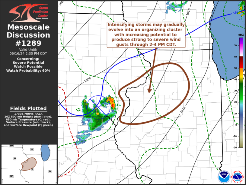
   Mesoscale Discussion 1289
   NWS Storm Prediction Center Norman OK
   1233 PM CDT Sun Jun 16 2024

   Areas affected...parts of southeastern Iowa and northwestern
   Illinois

   Concerning...Severe potential...Watch possible

   Valid 161733Z - 161930Z

   Probability of Watch Issuance...60 percent

   SUMMARY...A cluster of intensifying thunderstorms may pose a risk
   for small to marginally severe hail, before gradually organizing and
   posing increasing potential to produce strong to severe wind gusts
   through 2-4 PM CDT.  A severe weather watch will probably be needed
   at some point this afternoon, though it remains a bit uncertain how
   soon.

   DISCUSSION...Renewed thunderstorm development is underway near the
   center of a convectively generated or enhanced mid-level cyclonic
   vorticity center now approaching the Mississippi River vicinity
   between Burlington and Moline.  This perturbation is embedded within
   the southern portion of weak mid-level troughing which has emerged
   from the Great Plains and is forecast to continue shifting
   into/across the upper Great Lakes through late afternoon, while
   mid-level heights otherwise tend to rise.

   While deeper-layer shear is weak, an enhanced belt of
   lower/mid-troposperic flow (40+ kt centered around 700 mb) may
   contribute to shear profiles conducive to an upscale growing and
   organizing cluster of storms.  This will include a configuration
   allowing for easterly high-level system relative flow advecting
   anvil cloud cover and precipitation upstream (to the west), and not
   impeding destabilization within modest easterly near-surface updraft
   inflow.

   Mid-level inhibition for parcels within a gradually moistening
   boundary layer (including surface dew points now around or above
   70F) across northwestern Illinois is becoming increasingly
   negligible with continuing insolation, and CAPE is increasing in
   excess of 2000 J/kg.  As the updraft inflow of ongoing convection
   continues to become increasingly unstable, substantive further
   intensification and upscale growth seems probable during the next
   few hours.  It is possible that this could be accompanied a risk for
   marginally severe hail, before latent cooling in downdrafts
   gradually contributes to a strengthening northeastward and eastward
   propagating cold pool with increasing potential to produce strong to
   severe surface gusts.

   ..Kerr/Gleason.. 06/16/2024

   ...Please see www.spc.noaa.gov for graphic product...

   ATTN...WFO...LOT...ILX...DVN...

   LAT...LON   40429054 40489126 40849117 41029117 41349134 41689065
               42068990 42078913 41598873 41128889 40678959 40429054
|
|
Top/All Mesoscale Discussions/Forecast Products/Home
|
|


 @NWSSPC