|
| Mesoscale Discussion 1257 |
|
< Previous MD Next MD >
|
|
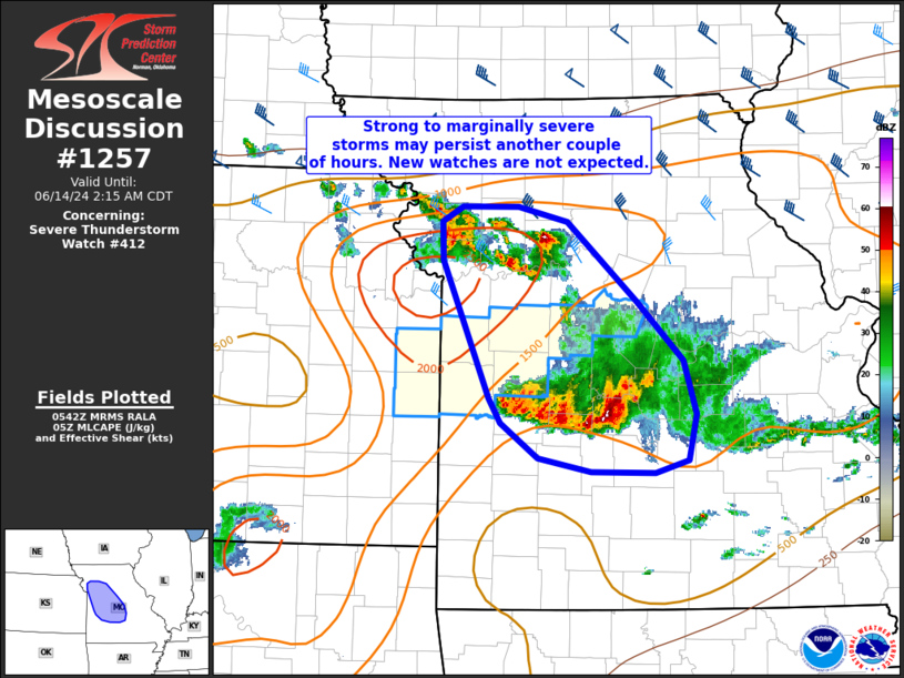
   Mesoscale Discussion 1257
   NWS Storm Prediction Center Norman OK
   1244 AM CDT Fri Jun 14 2024

   Areas affected...portions of western/central MO

   Concerning...Severe Thunderstorm Watch 412...

   Valid 140544Z - 140715Z

   The severe weather threat for Severe Thunderstorm Watch 412
   continues.

   SUMMARY...Sporadic strong to marginally severe storms may produce
   gusts of 45-60 mph and hail 0.75-1 inch diameter the next couple of
   hours. A new watch is not expected.

   DISCUSSION...A cluster of storms over central MO will continue to
   gradually develop south. Vertical shear remains rather weak with
   southward extent. Modest instability and steep midlevel lapse rates,
   in conjunction with a weak cold pool, may support sporadic strong
   storms another 1-2 hours before weakening occurs.

   Another cluster of storms further north are occurring atop the cold
   pool from prior convection, but in a more favorably sheared
   environment. The storms will pose mainly a marginally severe hail
   risk for another 1-2 hours.

   Given the marginal/sporadic nature of the threat, a new severe
   thunderstorm watch is not expected.

   ..Leitman.. 06/14/2024

   ...Please see www.spc.noaa.gov for graphic product...

   ATTN...WFO...LSX...SGF...EAX...

   LAT...LON   39729381 39599332 38969261 38499213 38069200 37699209
               37599242 37609308 37709361 37989399 38199412 39289459
               39599459 39729439 39729381
|
|
Top/All Mesoscale Discussions/Forecast Products/Home
|
|


 @NWSSPC