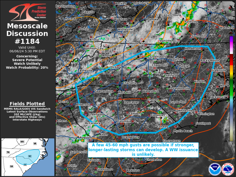
   Mesoscale Discussion 1184
   NWS Storm Prediction Center Norman OK
   0303 PM CDT Thu Jun 06 2024

   Areas affected...portions of far eastern Georgia into South Carolina
   and North Carolina

   Concerning...Severe potential...Watch unlikely

   Valid 062003Z - 062130Z

   Probability of Watch Issuance...20 percent

   SUMMARY...A few 45-60 mph gusts may occur with the stronger storms
   that can materialize this afternoon. The severe threat should remain
   isolated, so a WW issuance is not currently expected.

   DISCUSSION...Thunderstorms are percolating in intensity, with
   increasing trends in coverage being gradual at best. Surface
   temperatures are reaching or exceeding 90 F in several locales,
   which has supported convective initiation thus far. 7.5-8.5 C/km 0-3
   km lapse rates are supporting up to 2500 J/kg MLCAPE, which would
   favor 45-60 mph wind gusts with any of the stronger thunderstorms
   that can sustain themselves. However, 19Z mesoanalysis and 18Z RAP
   forecasting soundings show relatively weak tropospheric vertical
   wind profiles and accompanying shear. As such, mainly short-lived,
   pulse-cellular storms should be the dominant mode of convection,
   with damaging gusts likely to be limited in areal coverage and
   longevity, precluding a WW issuance at this time.

   ..Squitieri/Smith.. 06/06/2024

   ...Please see www.spc.noaa.gov for graphic product...

   ATTN...WFO...AKQ...MHX...RAH...ILM...RNK...CAE...GSP...

   LAT...LON   35218267 36278009 36467855 36437745 36057718 35397737
               34697782 34037867 33707955 33698047 33638095 33848168
               34068206 34278242 35218267
|


 @NWSSPC