|
| Mesoscale Discussion 1183 |
|
< Previous MD Next MD >
|
|
Mesoscale Discussion 1183
NWS Storm Prediction Center Norman OK
0252 PM CDT Thu Jun 06 2024
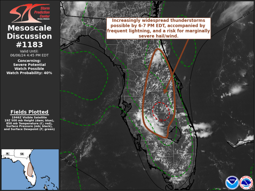
Areas affected...interior central Florida
Concerning...Severe potential...Watch possible
Valid 061952Z - 062045Z
Probability of Watch Issuance...40 percent
SUMMARY...Increasingly widespread strong thunderstorm development
appears likely across interior central Florida, including the
Greater Orlando vicinity, through 6-7 PM EDT. Stronger storms may
pose a risk for frequent cloud-to-ground lightning, marginally
severe hail and a few strong to severe wind gusts.
DISCUSSION...The initiation of widely scattered thunderstorms is
underway along the the inland advancing sea-breezes across the
Florida Peninsula. This is occurring in the presence of weak (10-15
kt) west-northwesterly deep-layer mean flow. Across north central
portions of the peninsula, downward mixing of the westerly flow to
the surface has contributed to the inland advance of the sea-breeze
from the Gulf coast, while the sea-breeze off the Atlantic is being
maintained closer to the Atlantic coast.
Across the interior peninsula, temperatures have heated into the mid
90s to around 100F, contributing to mixed-layer CAPE in excess of
2000 J/kg. With some further inland advance of the Atlantic
sea-breeze (and associated lower/mid 70s F dew points), CAPE may
increase further and maximize along its leading edge near the
interface with the stronger heating.
It appears that increasing low-level convergence along the colliding
sea-breezes may focus intensifying and increasingly widespread
thunderstorm development along a corridor west of Daytona Beach
through the Greater Orlando area and into the Avon Park/Sebring
vicinities by 22-23Z. Initial stronger cells may pose a risk for
marginally severe hail and locally strong downbursts, before gusty
winds along consolidating outflows becomes more prominent.
..Kerr/Smith.. 06/06/2024
...Please see www.spc.noaa.gov for graphic product...
ATTN...WFO...MFL...MLB...TBW...JAX...
LAT...LON 28438190 29688147 28968096 27708083 27198105 26948109
26858124 27308191 28438190
|
|
Top/All Mesoscale Discussions/Forecast Products/Home
|
|


 @NWSSPC