|
| Mesoscale Discussion 1142 |
|
< Previous MD Next MD >
|
|
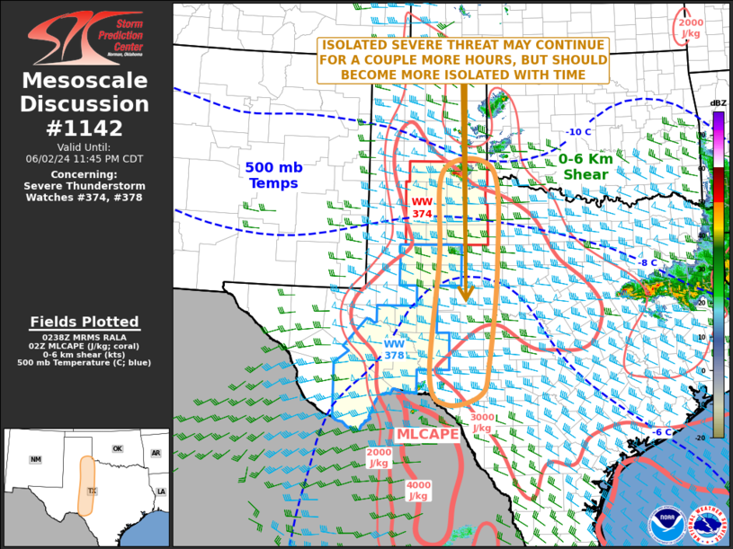
   Mesoscale Discussion 1142
   NWS Storm Prediction Center Norman OK
   0940 PM CDT Sun Jun 02 2024

   Areas affected...West-central Texas

   Concerning...Severe Thunderstorm Watch 374...378...

   Valid 030240Z - 030445Z

   The severe weather threat for Severe Thunderstorm Watch 374, 378
   continues.

   SUMMARY...An isolated severe threat will likely continue for a
   couple more hours across parts of west-central Texas. Large hail and
   severe wind gusts will be possible. The threat should become more
   isolated with time, and new watch issuance is not expected.

   DISCUSSION...Widely spaced thunderstorms are currently ongoing
   across parts of west-central Texas. One more vigorous supercell is
   located to the west of Childress, TX, with other cells southward
   across the Low Rolling Plains to near the Rio Grande River. The
   airmass along this corridor is strongly unstable, with MLCAPE in the
   2500 to 3500 J/kg range. In addition, RAP forecast soundings along
   this corridor have moderate deep-layer shear with relatively steep
   mid-level lapse rates. The environment will be sufficient for an
   isolated severe threat with cells that persist over the next hour or
   two. However, instability will begin to weaken across the much of
   the southern Plains, suggesting that any severe threat will become
   marginal.

   ..Broyles.. 06/03/2024

   ...Please see www.spc.noaa.gov for graphic product...

   ATTN...WFO...OUN...EWX...SJT...LUB...MAF...

   LAT...LON   29530100 29750017 30429997 32569974 34579986 34560111
               32660122 30110143 29530100
|
|
Top/All Mesoscale Discussions/Forecast Products/Home
|
|


 @NWSSPC