|
| Mesoscale Discussion 915 |
|
< Previous MD Next MD >
|
|
Mesoscale Discussion 0915
NWS Storm Prediction Center Norman OK
0554 PM CDT Thu May 23 2024
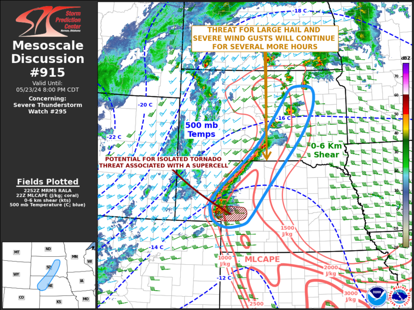
Areas affected...Western and Northern Nebraska...Central and Eastern
South Dakota
Concerning...Severe Thunderstorm Watch 295...
Valid 232254Z - 240100Z
The severe weather threat for Severe Thunderstorm Watch 295
continues.
SUMMARY...A threat for large hail and severe wind gusts is expected
to continue for several more hours from western and northern
Nebraska into central and eastern South Dakota. An isolated tornado
threat may continue across parts of southwest Nebraska.
DISCUSSION...The latest surface analysis shows a 997 mb low over
central South Dakota with a cold front extending southward from
western South Dakota into western Nebraska. A line of strong to
severe thunderstorms is ongoing ahead of the front. To the east of
this line, surface dewpoints are in the mid to upper 50s F, and the
RAP is analyzing a corridor of moderate instability with MLCAPE in
the 1500 to 2500 J/kg range. Forecast soundings from North Platte
northeastward into southern South Dakota generally have 0-6 km shear
in the 30 to 40 knot range, with 700-500 mb lapse rates of 7.5 to 8
C/km. This environment will support a severe threat, with isolated
large hail and wind damage possible. The wind damage threat will be
the greatest along the most intense parts of the line. A potential
for supercells will exist near the southern end of the line, to the
west of North Platte. In this vicinity, LCL heights are a bit lower
and surface dewpoints are near 60 F. This could be enough for an
isolated tornado threat with supercells that remain semi-discrete
this evening.
..Broyles.. 05/23/2024
...Please see www.spc.noaa.gov for graphic product...
ATTN...WFO...FSD...ABR...LBF...UNR...BOU...
LAT...LON 42080215 41640252 41260251 41030238 40850200 40820160
40930102 41140077 41410055 42000009 43679862 44479810
44929794 45269795 45419823 45379895 44929935 44369979
43350065 42080215
|
|
Top/All Mesoscale Discussions/Forecast Products/Home
|
|


 @NWSSPC