|
| Mesoscale Discussion 914 |
|
< Previous MD Next MD >
|
|
Mesoscale Discussion 0914
NWS Storm Prediction Center Norman OK
0253 PM CDT Thu May 23 2024
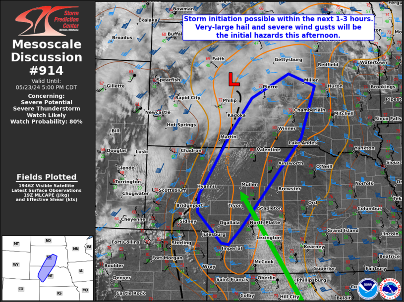
Areas affected...Western Nebraska into central South Dakota
Concerning...Severe potential...Severe Thunderstorm Watch likely
Valid 231953Z - 232200Z
Probability of Watch Issuance...80 percent
SUMMARY...A severe thunderstorm watch is likely this afternoon for
parts of western Nebraska into central South Dakota. Very-large hail
will be possible with initial supercells before a transition to a
more linear mode. Severe wind gusts will then become the dominant
threat.
DISCUSSION...Cumulus continue to increase along a surface
trough/cold front in western Nebraska and south-central South
Dakota. With the approach of the shortwave trough now in
western/central Wyoming, these trends should continue. Moisture
continues to increase ahead of the boundary, particularly into
western Nebraska, where a corridor of upper 50s F dewpoints are
noted farther southeast in surface observations. Objective
mesoanalysis shows decreasing MLCIN. Initiation of storms seems
probable in the next 1-3 hours. Storms will initially be supercells
capable of very large hail. Upscale growth may occur relatively
quickly given the linear forcing and larger T/Td spreads at the
surface. Severe wind gusts will become increasing likely as this
transition occurs.
..Wendt/Hart.. 05/23/2024
...Please see www.spc.noaa.gov for graphic product...
ATTN...WFO...FSD...ABR...LBF...UNR...
LAT...LON 40680140 40710163 41450239 41870234 43410129 44180067
44759946 44459861 43219907 41060102 40680140
|
|
Top/All Mesoscale Discussions/Forecast Products/Home
|
|


 @NWSSPC