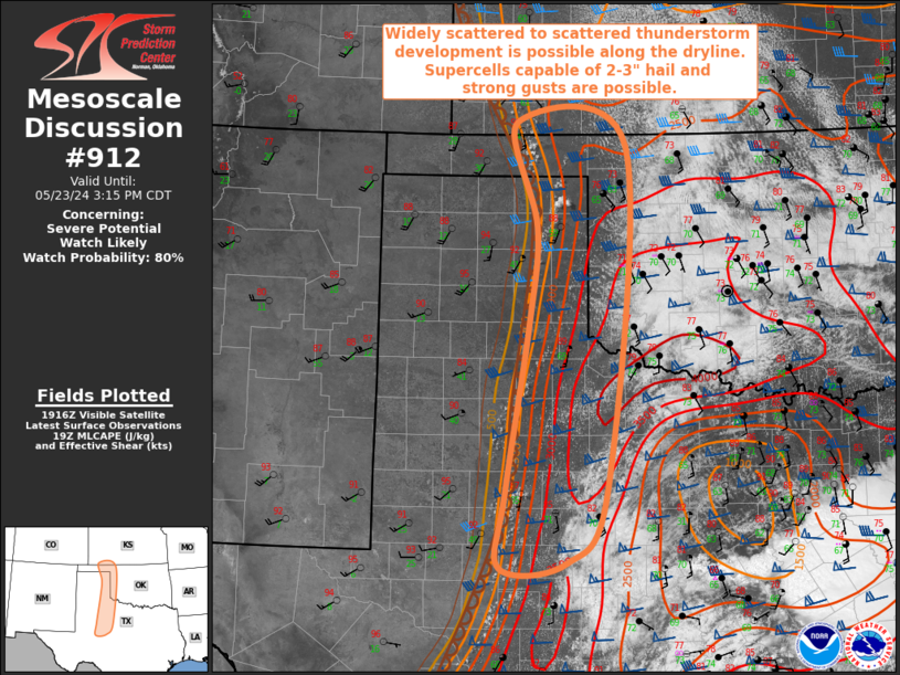
   Mesoscale Discussion 0912
   NWS Storm Prediction Center Norman OK
   0222 PM CDT Thu May 23 2024

   Areas affected...Far Southwest KS...Eastern TX/OK
   Panhandles...Western OK...TX Big Country...Southwest TX

   Concerning...Severe potential...Watch likely

   Valid 231922Z - 232015Z

   Probability of Watch Issuance...80 percent

   SUMMARY...Widely scattered to scattered thunderstorm development is
   anticipated along the dryline from southwest Kansas into southwest
   Texas. Supercells capable of very large hail up to 2 to 3" and
   strong gusts are possible. One or more watches will likely be needed
   across portions of the area to address this severe potential.

   DISCUSSION...Recent surface analysis places a dryline from far
   southwestern KS southward through the eastern TX and OK Panhandles,
   TX Big County, and southwest TX. Visible satellite imagery shows
   some building cumulus in the vicinity of this dryline, with the most
   notable clusters currently in the eastern OK, the northeast TX
   Panhandle, and in southwest TX (about 20-30 miles east of BGS).

   Airmass to the east of this dryline is very warm and moist, with
   temperatures in the upper 80s/low 90s and dewpoints ranging from the
   upper 60s/low 70s across southwest TX to the low 60s across eastern
   OK Panhandle and far southwest KS. Steep mid-level lapse rates exist
   atop these surface conditions, supporting very strong buoyancy.
   Recent mesoanalysis estimates around 3000 J/kg along much of the
   dryline, with lower values in the eastern OK Panhandle and southwest
   KS.

   Stronger low-level convergence exists from southwest KS into the
   southeast TX Panhandle, with a low-amplitude shortwave trough
   evident in water vapor imagery approaching this region as well. Less
   low-level convergence is anticipated farther south, but the airmass
   is also more moist, with lower convective inhibition and less
   influence from dry-air entrainment. These factors are expected to
   support widely scattered to scattered thunderstorm initiation along
   the dryline with in the next hour or so. Supercells capable of very
   large hail up to 2 to 3" will likely be the primary risk, but strong
   gusts are possible as well. The tornado threat will likely be
   limited by weak low-level shear, although not zero given the
   expected supercellular mode. One or more watches will likely be
   needed across portions of the area to address this severe potential.

   ..Mosier/Hart.. 05/23/2024

   ...Please see www.spc.noaa.gov for graphic product...

   ATTN...WFO...OUN...DDC...SJT...LUB...AMA...MAF...

   LAT...LON   31790126 32680118 34730085 35880074 37140103 36869944
               32769972 31860031 31790126
|


 @NWSSPC