|
| Mesoscale Discussion 718 |
|
< Previous MD Next MD >
|
|
Mesoscale Discussion 0718
NWS Storm Prediction Center Norman OK
0759 PM CDT Wed May 08 2024
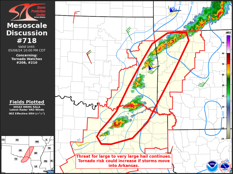
Areas affected...North Texas into southeast Oklahoma and northwest
Arkansas
Concerning...Tornado Watch 208...210...
Valid 090059Z - 090300Z
The severe weather threat for Tornado Watch 208, 210 continues.
SUMMARY...Large to very-large hail and severe wind gusts should
remain the greatest threat this evening. Discrete storms moving into
the low-level jet axis in Arkansas would pose the greatest tornado
threat.
DISCUSSION...Large to very-large hail will remain possible,
especially with discrete storms near the Red River. Storms in
northwest Arkansas/northeast Oklahoma have already become more
linear and likely to remain so. A modest increase in the low-level
jet is expected over the 1-3 hours in Arkansas. Discrete storms that
move into Arkansas could pose a greater tornado threat as a result.
There is some inhibition farther east as observed by the 00Z LZK
sounding. Any increase in CIN this evening should be slow given the
moist low-level environment. Particularly if storms congeal, the
cold pool in combination with the low-level jet could sustain
convection farther east than expected.
Other than currently weak convection in Lampasas County, prospects
for additional development south of the DFW metro are not certain.
Visible satellite has shown downward trends in cumulus over the last
few hours.
..Wendt.. 05/09/2024
...Please see www.spc.noaa.gov for graphic product...
ATTN...WFO...LZK...SHV...TSA...FWD...OUN...
LAT...LON 32779698 32979684 33319651 33669617 34559568 35499507
36059466 36429400 36459347 36429318 36159308 35169368
33289487 32729550 32509637 32509679 32779698
|
|
Top/All Mesoscale Discussions/Forecast Products/Home
|
|


 @NWSSPC