|
| Mesoscale Discussion 717 |
|
< Previous MD Next MD >
|
|
Mesoscale Discussion 0717
NWS Storm Prediction Center Norman OK
0742 PM CDT Wed May 08 2024
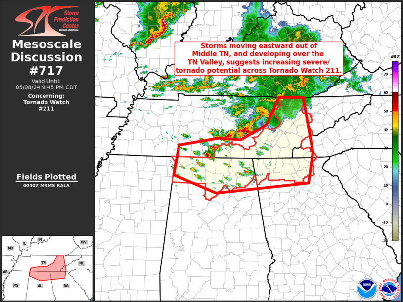
Areas affected...northern Alabama...southern Middle and into eastern
Tennessee...northwestern Georgia...and far western North Carolina
Concerning...Tornado Watch 211...
Valid 090042Z - 090245Z
The severe weather threat for Tornado Watch 211 continues.
SUMMARY...Severe/tornado threat is increasing across Tornado Watch
211 -- from the Tennessee Valley into the southern Appalachians.
DISCUSSION...Latest radar loop across the region shows storms
increasing rapidly in coverage and intensity from northern Alabama
and southern Middle Tennessee, eastward to southeastern Tennessee
and northwestern Georgia. This appears to be occurring in response
to an increase in low-level warm advection, associated with a
gradually veering low-level jet. Meanwhile, strong storms --
including a long-lived supercell now moving into the Warren County
Tennessee vicinity -- are expected to continue moving eastward out
of WW 206 into Tornado Watch 211 in the next hour or so.
With this area on the eastern edge of a very moist/unstable airmass
across the lower Mississippi and Tennessee Valleys, and shear
favoring organized/rotating storms, severe/isolated tornado risk
should continue to increase in the short term, across this area.
..Goss.. 05/09/2024
...Please see www.spc.noaa.gov for graphic product...
ATTN...WFO...GSP...MRX...JKL...FFC...OHX...BMX...HUN...MEG...
LAT...LON 34508813 35318797 35508669 35478597 35878515 36598472
36598392 35138364 34308380 34058676 34508813
|
|
Top/All Mesoscale Discussions/Forecast Products/Home
|
|


 @NWSSPC