|
| Mesoscale Discussion 648 |
|
< Previous MD Next MD >
|
|
Mesoscale Discussion 0648
NWS Storm Prediction Center Norman OK
1107 AM CDT Mon May 06 2024
Areas affected...Far northwest Nebraska into western South Dakota
and far southwest North Dakota
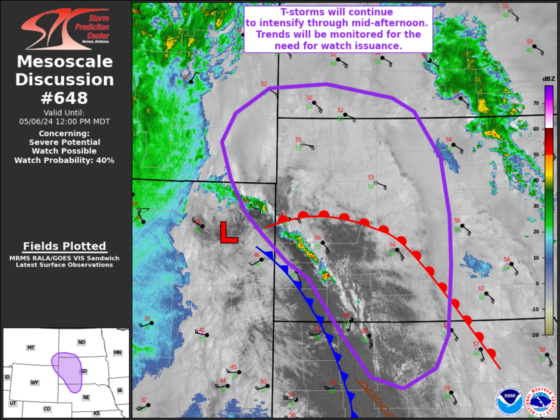
Concerning...Severe potential...Watch possible
Valid 061607Z - 061800Z
Probability of Watch Issuance...40 percent
SUMMARY...Thunderstorms developing along a cold front in the
vicinity of a deepening surface low are expected to continue
intensifying through the mid-afternoon hours. This activity may
strengthen to severe limits and require watch issuance by late
morning/early afternoon.
DISCUSSION...Over the past hour, strong surface pressure falls (on
the order of 1-2 mb/hour) have been observed across the western
Dakotas amid increasing synoptic ascent over the northern High
Plains. Concurrently, a Pacific cold front is pushing east and
impinging on a narrow corridor of returning moisture. Consequently,
weak convection has developed along the front and in the vicinity of
the surface low.
The expectation for the next several hours is for this activity to
intensify owing to a combination of continued theta-e advection into
a narrow warm sector (confined to the east by thick low/mid-level
stratus that is resulting in muted diurnal warming) and steepening
mid-level lapse rates associated with strong synoptic ascent and
cooling temperatures aloft. MLCAPE values are forecast to reach
1500-2000 J/kg by mid-afternoon, which appears to be on track based
on recent observed trends. Southerly mid/upper-level winds will
support off-boundary organization of cells that may favor discrete
to semi-discrete storm modes. Large hail (most likely 1.0 to 1.5
inches in diameter) and severe gusts will be the predominant hazard,
but low-level helicity within the warm sector (observed values
around 150 m2/s2 are noted in the KUDX VWP) combined with ample
ambient vorticity along the boundary should support a tornado threat
with more intense cells. The narrow spatial extent of the warm
sector introduces some uncertainty into the overall coverage of the
severe threat, but trends will continue to be monitored for the need
of watch issuance.
..Moore/Smith.. 05/06/2024
...Please see www.spc.noaa.gov for graphic product...
ATTN...WFO...ABR...BIS...LBF...UNR...CYS...BYZ...
LAT...LON 42820272 43630338 43870382 44260430 44580466 45050498
45570517 46000490 46370422 46430302 46240166 46030122
45370069 44520052 43800051 42790060 42310085 42020150
42200213 42820272
|
|
Top/All Mesoscale Discussions/Forecast Products/Home
|
|


 @NWSSPC