|
| Mesoscale Discussion 647 |
|
< Previous MD Next MD >
|
|
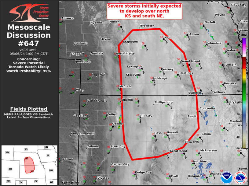
   Mesoscale Discussion 0647
   NWS Storm Prediction Center Norman OK
   1057 AM CDT Mon May 06 2024

   Areas affected...northwest/north-central KS and south-central NE

   Concerning...Severe potential...Tornado Watch likely

   Valid 061557Z - 061800Z

   Probability of Watch Issuance...95 percent

   SUMMARY...An arc of severe thunderstorms should develop by early
   afternoon along the composite cold front/dryline. Tornadoes, large
   hail, and severe wind gusts are expected with a midday tornado watch
   issuance.

   DISCUSSION...15Z surface analysis placed the composite cold
   front/dryline across southwest NE into far western KS. A lobe of
   large-scale ascent indicated by a patch of upper-level cirrus along
   the KS/CO border will rapidly spread northeast and likely aid in
   convective development along the KS/NE border area during the next
   few hours. A plume of at least moderate buoyancy is already present,
   with earlier MLCIN noted in 12Z LBF/DDC soundings waning.
   Enlarged/elongated hodographs will favor supercell structures,
   especially with southern extent where a couple strong tornadoes will
   be possible. Linear frontal forcing and potential for pinching of
   the northeast portion of the surface-based buoyancy plume should
   yield greater potential for upscale growth earlier with northern
   extent. A mix of tornadoes, large hail, and severe wind gusts is
   expected.

   ..Grams/Smith.. 05/06/2024

   ...Please see www.spc.noaa.gov for graphic product...

   ATTN...WFO...TOP...ICT...GID...LBF...DDC...GLD...

   LAT...LON   39220046 40650055 41430064 41860013 41919910 41219818
               40069774 39069768 38519826 38269914 38170010 38680039
               39220046
|
|
Top/All Mesoscale Discussions/Forecast Products/Home
|
|


 @NWSSPC