|
| Mesoscale Discussion 136 |
|
< Previous MD Next MD >
|
|
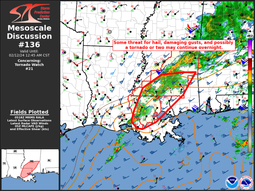
   Mesoscale Discussion 0136
   NWS Storm Prediction Center Norman OK
   1119 PM CST Sun Feb 11 2024

   Areas affected...Southeast LA into southern MS

   Concerning...Tornado Watch 21...

   Valid 120519Z - 120645Z

   The severe weather threat for Tornado Watch 21 continues.

   SUMMARY...Some threat for hail, damaging gusts, and possibly a
   tornado or two may continue overnight.

   DISCUSSION...Scattered strong thunderstorms are ongoing from near
   the LA coast into southern MS, in advance of a cold front that is
   approaching from the west. Moderate buoyancy (with MLCAPE of up to
   1500 J/kg) and strong deep-layer shear will continue to promote
   storm organization, with occasional supercell structures potentially
   persisting into the early overnight hours. Hail will likely continue
   to be the primary threat, with localized strong/damaging gusts also
   possible. While surface winds to the south of the composite outflow
   boundary have recently veered somewhat, low-level shear remains
   sufficient to support at least a brief tornado threat, given the
   rich low-level moisture in place (with dewpoints near 70F).

   There is some potential for the severe threat to persist across at
   least the southern portion of WW 21 after the 07Z expiration time.
   Local extension or new watch issuance may need to be considered,
   depending on trends regarding storm coverage and intensity over the
   next 60-90 minutes.

   ..Dean/Hart.. 02/12/2024

   ...Please see www.spc.noaa.gov for graphic product...

   ATTN...WFO...MOB...JAN...LIX...LCH...

   LAT...LON   31058917 29939047 29639110 29679136 29939162 30359153
               31339111 31889022 31978916 31978856 31138911 31058917
|
|
Top/All Mesoscale Discussions/Forecast Products/Home
|
|


 @NWSSPC