|
| Mesoscale Discussion 1391 |
|
< Previous MD Next MD >
|
|
Mesoscale Discussion 1391
NWS Storm Prediction Center Norman OK
0326 PM CDT Thu Jul 29 2021
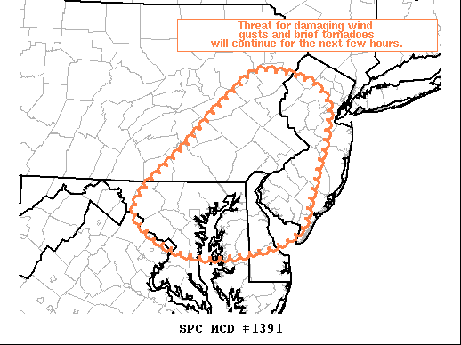
Areas affected...Southeastern PA...NJ...Northern VA...Central
MD...Delmarva
Concerning...Tornado Watch 401...
Valid 292026Z - 292200Z
The severe weather threat for Tornado Watch 401 continues.
SUMMARY...Threat for damaging wind gusts and/or brief tornadoes will
continue for the next few hours.
DISCUSSION...A large area of showers and thunderstorms continues to
move eastward across the northern Mid-Atlantic. Much of this
activity has remained shallow and transient. However, a few more
robust updrafts have been able to develop, including two which are
currently ongoing over MD, one over Carroll County MD and the other
over Howard County MD, and another over Lehigh County PA. Low to
mid-level rotation has been noted in each one of these storms,
suggesting the slightly stronger flow associated with this shortwave
trough (sampled well by recent LWX VAD profiles) coupled with the
southerly surface winds is enough to promote updraft rotation. This
current trend of transient updrafts capable of damaging wind gusts
and/or brief tornadoes will likely continue for the next few hours.
..Mosier.. 07/29/2021
...Please see www.spc.noaa.gov for graphic product...
ATTN...WFO...OKX...PHI...CTP...LWX...
LAT...LON 40877596 41147542 40787442 39667467 38997507 38787661
39347758 40167678 40877596
|
|
Top/All Mesoscale Discussions/Forecast Products/Home
|
|


 @NWSSPC