|
| Mesoscale Discussion 709 |
|
< Previous MD Next MD >
|
|
Mesoscale Discussion 0709
NWS Storm Prediction Center Norman OK
0544 PM CDT Mon May 20 2019
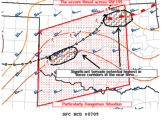
Areas affected...Much of Oklahoma and portions of western north
Texas
Concerning...Tornado Watch 199...
Valid 202244Z - 202345Z
The severe weather threat for Tornado Watch 199 continues.
SUMMARY...The severe threat continues across WW 199. A volatile
environment remains in place across the discussion area with all
modes of severe (including significant tornadoes) remaining
possible.
DISCUSSION...In the short term, tornado potential appears to be
maximized in a couple of areas - one over Greer County, OK (where
recent radar trends indicate potential for significant tornadoes and
very large hail) and near Noble/Payne Counties in OK where a
forward-propagating linear segment may interact with an outflow/warm
frontal boundary immediately downstream of that region.
Surface-based storms continue in a very volatile shear/instability
combination, with all modes of severe remaining possible (including
significant tornadoes). Shear will only increase in response to
significant strengthening of low-level flow through the evening.
A convectively modified surface boundary continues to migrate slowly
southward across west-central Oklahoma and resides along a line from
near PNC to just south of CSM and westward to south of AMA. Storms
north of this boundary will be elevated, but capable of large hail.
If the current storm near Greer County, OK can continue on the warm
side of the boundary, it will continue with a risk of occasional
strong to violent tornadogenesis in addition to large hail and
damaging wind gusts.
..Cook.. 05/20/2019
...Please see www.spc.noaa.gov for graphic product...
ATTN...WFO...OUN...LUB...AMA...
LAT...LON 34820037 35489911 36019800 35849744 34419956 34820037
|
|
Top/All Mesoscale Discussions/Forecast Products/Home
|
|


 @NWSSPC