|
| Mesoscale Discussion 1039 |
|
< Previous MD Next MD >
|
|
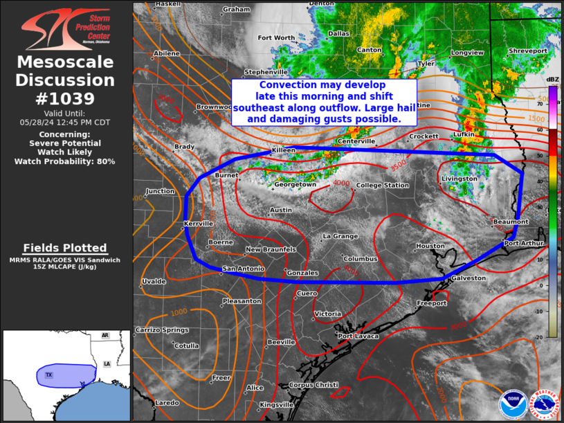
   Mesoscale Discussion 1039
   NWS Storm Prediction Center Norman OK
   1049 AM CDT Tue May 28 2024

   Areas affected...central into southeast TX

   Concerning...Severe potential...Watch likely

   Valid 281549Z - 281745Z

   Probability of Watch Issuance...80 percent

   SUMMARY...Storms may develop along residual outflow across central
   into southeast Texas from late morning into the afternoon.
   Severe/damaging gusts and large hail will be possible. A watch will
   likely be needed soon.

   DISCUSSION...Convection is starting to develop near/just behind
   outflow across central Texas. While outflow may continue to sag
   southward, a very moist airmass remains in place with surface
   dewpoints in the mid/upper 70s F. Strong heating and midlevel lapse
   rates around 8-8.5 C/km within this moist environment is resulting
   in strong destabilization (MLCAPE around 2000-4000 J/kg). Any storms
   that develop within this airmass will likely become severe, posing a
   risk of large hail and severe gusts. If clustering occurs, a line of
   severe storms may develop southeast from the Edwards Plateau toward
   the Upper Texas Coast later this afternoon. A watch will likely be
   needed for portions of the region soon.

   ..Leitman/Hart.. 05/28/2024

   ...Please see www.spc.noaa.gov for graphic product...

   ATTN...WFO...LCH...SHV...HGX...FWD...EWX...SJT...

   LAT...LON   30519909 30769888 31059830 31229733 31109402 30839358
               30209367 29939375 29609436 29359492 29309566 29319726
               29359789 29439833 29509868 29629891 29959906 30189910
               30519909
|
|
Top/All Mesoscale Discussions/Forecast Products/Home
|
|


 @NWSSPC