ZCZC SPCFWDDY1 ALL
FNUS21 KWNS 021637
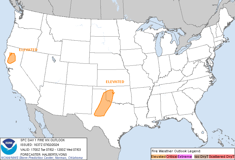
Day 1 Fire Weather Outlook
NWS Storm Prediction Center Norman OK
1137 AM CDT Tue Jul 02 2024
Valid 021700Z - 031200Z
...17Z Update...
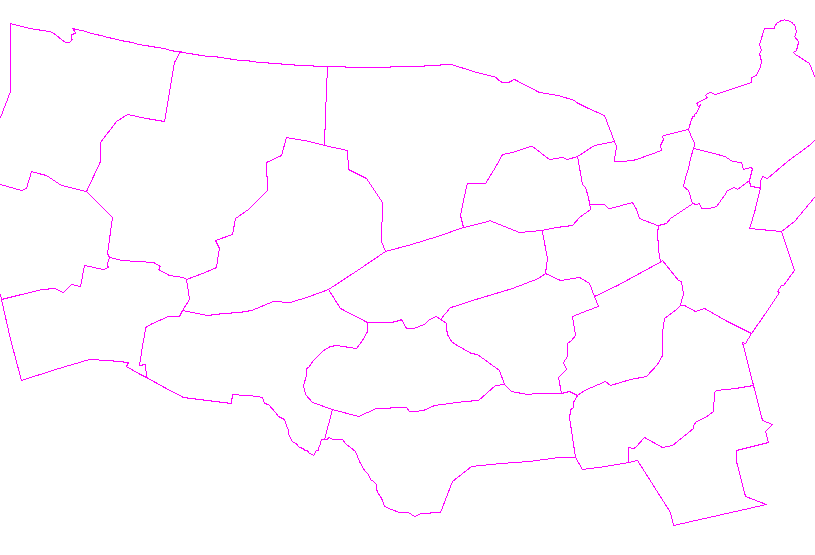
The previous forecast remains valid and largely unchanged. An
expansion of the Southern Plains Elevated area further southwest
into Central TX was introduced in order to cover hot, dry, and windy
conditions this afternoon and early evening that overlap with
supportive fuels. Localized dry and breezy conditions may occur
across Southwest OR. However, no Elevated highlight will be
introduced at this time. See previous discussion for more
information.
..Halbert/Lyons.. 07/02/2024
.PREV DISCUSSION... /ISSUED 0143 AM CDT Tue Jul 02 2024/
...Synopsis...
Broad cyclonic mid-level flow will overspread much of the
northwestern and north-central CONUS today, with an embedded
mid-level impulse overspreading the northern Plains as a 500 mb jet
max impinges on the Pacific Northwest. Coincident with low pressure
development in the Central California Valley region, 15+ mph
sustained northerly surface winds may develop by afternoon in the
Sacramento into Napa Valleys as RH drops to or just below 15
percent. Given receptive fuels in this region, Elevated highlights
have been maintained.
Locally dry and breezy conditions should also develop along the lee
of the Cascade Ranges into the Harney and Columbia basins in eastern
Oregon and Washington (respectively). Fuels continue to cure across
the Pacific Northwest, but are currently only modestly receptive at
best on a widespread basis. Given the localized nature of the dry
and breezy conditions, and given modest fuel receptiveness, no fire
weather highlights have been introduced.
Finally, surface low development over the central Plains will
encourage dry southerly low-level flow over the southern High Plains
as the boundary layer deepens and mixes by afternoon. Latest
guidance consensus depicts 15-20 mph sustained south-southwesterly
surface winds overlapping 20-25 percent RH for at least a few hours.
Given the stress of fuels under hot conditions over the past few
days, fuels may be receptive enough to support wildfire-spread
potential, hence the maintenance of Elevated fire weather
highlights.
...Please see www.spc.noaa.gov/fire for graphic product...
CLICK FOR DAY 1 FIREWX AREAL OUTLINE PRODUCT (KWNSPFWFD1)


 @NWSSPC
