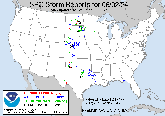
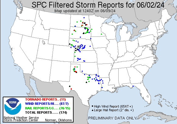
| Tornado Reports (CSV) (Raw Tornado CSV)(?) |
|---|
Time | | Location | County | State | Lat | Lon | Comments |
| 1939 | | 1 NNE Burnstad | Logan | ND | 4641 | 9962 | Photo of landspout tornado relayed from broadcast media. Unknown duration. (BIS) |
| 1948 | | 5 S Woodworth | Stutsman | ND | 4707 | 9930 | Public report of stovepipe tornado south of Woodworth. Persisted for at least 10 minutes before becoming rain wrapped and caller lost visual confirmation. (BIS) |
| 2116 | | 11 NNE Opal | Meade | SD | 4502 | 10233 | Meade County Sheriff's Office confirms a tornado crossed Highway 212 around MM 100 ... 14 miles west of Faith. (UNR) |
| 2116 | | 9 NNE Opal | Meade | SD | 4502 | 10239 | Meade County Sheriff's Office confirms a tornado crossed Highway 212 around MM 97 ... 17 miles west of Faith. (UNR) |
| 0011 | | 4 WNW Sanford | Hutchinson | TX | 3572 | 10159 | Corrects previous tornado report from 4 WNW Sanford. NWS employee reported tornado on the ground. This tornado formed over Lake Meredith. The track of the tornado was p (AMA) |
| 0012 | | 4 WNW Sanford | Hutchinson | TX | 3572 | 10159 | NWS employee reported tornado on the ground. (AMA) |
| 0014 | | 1 WNW Sanderson | Terrell | TX | 3015 | 10242 | Photos showed a tornado formed very near Sanderson along a ridge northwest of town. This tornado immediately entered a neighborhood west of US Highway 285 in Sanderson. (MAF) |
| 0015 | | Sanderson | Terrell | TX | 3014 | 10239 | Tornado with damage to buildings and power lines reported in Sanderson. (MAF) |
| 0016 | | 3 WNW Sanford | Hutchinson | TX | 3572 | 10159 | A second EF0 tornado formed and moved northeast between Lake Meredith and the Bugbee community. Was on the ground for about 2 minutes with a path width of 75 yards and (AMA) |
| 0020 | | Sanderson | Terrell | TX | 3014 | 10240 | The same supercell thunderstorm that caused the first tornado would quickly prouce another smaller tornado near the center of Sanderson a short time later. This tornado (MAF) |
| 0052 | | Fort Ransom | Ransom | ND | 4652 | 9793 | A trained storm spotter (DouglasB27) reported a tornado moving southeast near highway 32 and hasd been on the ground 5 minutes prior to call. (FGF) |
| 0056 | | 10 NW Silverton | Briscoe | TX | 3457 | 10143 | Location estimated by chaser. (LUB) |
| 0102 | | 7 N Silverton | Briscoe | TX | 3457 | 10131 | This is another observation of the initial tornado with this storm. (LUB) |
| 0120 | | 6 NNE Silverton | Briscoe | TX | 3456 | 10127 | Tornado observed live on storm chaser video feed. (LUB) |
| Hail Reports (CSV) (Raw Hail CSV)(?) |
|---|
Time | Size | Location | County | State | Lat | Lon | Comments |
| 1358 | 200 | 5 S Webster | Day | SD | 4526 | 9752 | Time estimated by radar. (ABR) |
| 1930 | 100 | Harrisburg | Banner | NE | 4155 | 10374 | Trained weather spotter reports quarter sized hail in Harrisburg ... NE. (CYS) |
| 1935 | 150 | 5 ESE Harrisburg | Banner | NE | 4152 | 10366 | TRAINED SPOTTER REPORTS PING PONG SIZE HAIL STONES NEAR THE SOUTH BOUND WEIGH STATION OFF HIGHWAY 71 IN BANNER COUNTY ... NE. (CYS) |
| 1940 | 200 | 4 E Harrisburg | Banner | NE | 4154 | 10366 | STORM CHASER REPORT OF TWO INCH DIAMETER HAIL NEAR THE HILLTOP CAFE OFF HIGHWAY 71 IN BANNER COUNTY. (CYS) |
| 2000 | 100 | 11 N Zeeland | McIntosh | ND | 4612 | 9980 | 2 minute duration. Also reported winds up to around 40 mph. (BIS) |
| 2000 | 100 | 1 W Woodworth | Stutsman | ND | 4714 | 9932 | Relayed through social media. Time estimated from radar. (BIS) |
| 2023 | 150 | Goodrich | Sheridan | ND | 4748 | 10012 | Winds around 15 miles per hour ... very little rain observed. Hail fell for around 8 minutes. (BIS) |
| 2030 | 100 | 2 W Rapid City Arpt | Pennington | SD | 4403 | 10309 | (UNR) |
| 2030 | 100 | 7 E Burnstad | Logan | ND | 4639 | 9949 | Mostly pea sized hail with some quarter sized hail mixed in. Also rain around 2.4 inches over the course of an hour ... 2:30-3:30 PM CDT. Culverts were observed to be ru (BIS) |
| 2030 | 200 | 4 SSW Woodworth | Stutsman | ND | 4709 | 9932 | (BIS) |
| 2040 | 175 | 13 NE Potter | Cheyenne | NE | 4133 | 10316 | Corrects previous hail report from 11 NE Potter. Public report relayed by Emergency Management. (CYS) |
| 2055 | 100 | 1 S Gainesville | Cooke | TX | 3362 | 9714 | Report from mPING: Quarter (1.00 in.). (FWD) |
| 2104 | 175 | 4 E Gainesville | Cooke | TX | 3365 | 9709 | Cooke County EM reported golf-ball sized hail on the east side of Gainesville on Hwy 82 east of Radio Hill Rd. (FWD) |
| 2106 | 150 | 14 SSE Hay Springs | Sheridan | NE | 4250 | 10258 | (LBF) |
| 2111 | 100 | Gurley | Cheyenne | NE | 4132 | 10297 | (CYS) |
| 2112 | 250 | 17 SW Usta | Perkins | SD | 4505 | 10240 | (UNR) |
| 2120 | 175 | 12 NE Opal | Meade | SD | 4502 | 10229 | (UNR) |
| 2130 | 100 | 8 NE Sidney | Cheyenne | NE | 4122 | 10286 | TRAINED SPOTTER REPORTS HAIL UP TO THE SIZE OF ONE INCH IN DIAMETER. DELAYED REPORT. (CYS) |
| 2150 | 150 | 28 SSE Clinton | Sheridan | NE | 4238 | 10214 | (LBF) |
| 2153 | 150 | 4 NNW Denton | Denton | TX | 3326 | 9716 | HAM report of ping-pong ball sized hail near Loop 288 and Hwy 77 in Denton. (FWD) |
| 2155 | 100 | 1 W Decatur | Wise | TX | 3323 | 9761 | Report from mPING: Quarter (1.00 in.). (FWD) |
| 2158 | 100 | 2 NE Denton | Denton | TX | 3323 | 9710 | Report from mPING: Quarter (1.00 in.). (FWD) |
| 2201 | 100 | 12 N North Lemmon | Adams | ND | 4612 | 10216 | Relayed through social media. Noted lots of hail ... mainly marble sized ... and that it came down very heavy. (BIS) |
| 2209 | 100 | 1 W Denton | Denton | TX | 3321 | 9715 | Report from mPING: Quarter (1.00 in.). (FWD) |
| 2213 | 100 | 2 S Hackberry | Denton | TX | 3312 | 9692 | Report from mPING: Quarter (1.00 in.). (FWD) |
| 2216 | 100 | 1 WNW Red Scaffold | Ziebach | SD | 4477 | 10186 | (UNR) |
| 2223 | 100 | Ovid | Sedgwick | CO | 4096 | 10239 | Report from mPING: Quarter (1.00 in.). (BOU) |
| 2224 | 175 | 5 E Rhome | Denton | TX | 3303 | 9738 | Report from mPING: Golf Ball (1.75 in.). (FWD) |
| 2225 | 400 | 2 SSE Fort Stockton | Pecos | TX | 3087 | 10287 | Hail ranged in size from golf ball to softball. (MAF) |
| 2225 | 175 | Fort Stockton | Pecos | TX | 3089 | 10289 | Golf ball sized hail on the south side of Fort Stockton. (MAF) |
| 2228 | 175 | 1 SW Fort Stockton | Pecos | TX | 3088 | 10290 | Hail ranged in size from half dollar to golf ball. (MAF) |
| 2229 | 100 | 2 E De Quincy | Calcasieu | LA | 3045 | 9341 | Former NWS employee reports quarter size hail east of DeQuincy. (LCH) |
| 2238 | 100 | 1 S Aledo | Parker | TX | 3268 | 9761 | Report from mPING: Quarter (1.00 in.). (FWD) |
| 2245 | 100 | 8 WNW Bancroft | Beadle | SD | 4453 | 9790 | A few quarter size hail stones. (FSD) |
| 2251 | 100 | 1 ESE Jamestown | Stutsman | ND | 4690 | 9869 | Relayed through social media. (BIS) |
| 2252 | 100 | 2 W Benbrook | Tarrant | TX | 3267 | 9750 | Report from mPING: Quarter (1.00 in.). (FWD) |
| 2252 | 125 | 1 SSE Jamestown | Stutsman | ND | 4690 | 9870 | Lots of hail from peas to quarters in size ... with some half dollar sized hail mixed in. Some damage to vegetation and to vehicles. (BIS) |
| 2257 | 125 | 3 W Benbrook | Tarrant | TX | 3269 | 9751 | Report from mPING: Half Dollar (1.25 in.). (FWD) |
| 2257 | 125 | 5.5 W Barnard | Brown | SD | 4572 | 9861 | (ABR) |
| 2300 | 100 | 1 S Fort Worth | Tarrant | TX | 3274 | 9734 | Report from mPING: Quarter (1.00 in.). (FWD) |
| 2300 | 150 | Jamestown | Stutsman | ND | 4691 | 9871 | Reported by spotter visiting downtown Jamestown. Also reported strong winds and heavy rain. (BIS) |
| 2305 | 100 | 7 NW Canyon | Randall | TX | 3506 | 10201 | (AMA) |
| 2310 | 100 | 16 SSE Canyon | Randall | TX | 3475 | 10186 | (AMA) |
| 2311 | 275 | 2 S Miller Dale Colony | Hand | SD | 4437 | 9911 | (ABR) |
| 2316 | 275 | Miller Dale Colony | Hand | SD | 4440 | 9911 | (ABR) |
| 2320 | 100 | 1 W Happy | Swisher | TX | 3473 | 10188 | Report from mPING: Quarter (1.00 in.). (LUB) |
| 2320 | 175 | 14 N Amarillo | Potter | TX | 3540 | 10184 | (AMA) |
| 2321 | 275 | 3 NNW Barnard | Brown | SD | 4577 | 9851 | EM reports golfball to baseball hail. (ABR) |
| 2330 | 125 | 4 NW Timbercreek Canyon | Randall | TX | 3510 | 10187 | (AMA) |
| 2330 | 125 | 6 SSW Amarillo | Randall | TX | 3513 | 10187 | (AMA) |
| 2330 | 100 | 7 SE Clark | Clark | SD | 4482 | 9763 | (ABR) |
| 2330 | 125 | 1 N Barnard | Brown | SD | 4575 | 9850 | (ABR) |
| 2330 | 100 | 1 W Spiritwood | Stutsman | ND | 4694 | 9852 | 1.50 inches of rain fell in about 30 minutes as well. (BIS) |
| 2345 | 275 | 4 S Miller | Hand | SD | 4446 | 9898 | Report from mPING: Baseball (2.75 in.). (ABR) |
| 2345 | 125 | 2 W Willow Lake | Clark | SD | 4463 | 9768 | (ABR) |
| 2349 | 100 | 7 ENE Amarillo | Potter | TX | 3523 | 10171 | This report was here at the NWS Amarillo office. (AMA) |
| 2350 | 175 | 4 W Sand Lake Wildlife | Brown | SD | 4576 | 9834 | (ABR) |
| 2353 | 175 | 4 SE Willow Lake | Clark | SD | 4459 | 9758 | Photo of ping pong to golf ball sized hail on Facebook. Time estimated from radar. (ABR) |
| 2358 | 125 | Stratton | Hitchcock | NE | 4015 | 10123 | picture of hail compared to a quarter via facebook ... stones appear to be larger than the quarter. (GLD) |
| 0000 | 100 | Stratton | Hitchcock | NE | 4015 | 10123 | Report and photo via social media. (GLD) |
| 0002 | 175 | 6 WNW Sanford | Moore | TX | 3575 | 10162 | Partner at Pantex. (AMA) |
| 0002 | 100 | 4 SSE Fordham Colony | Clark | SD | 4471 | 9788 | Quarter sized hail and 0.95 inch of rain. (ABR) |
| 0005 | 175 | 3 W Trenton | Hitchcock | NE | 4018 | 10106 | Report of golf ball size hail. (GLD) |
| 0005 | 175 | 3 W Trenton | Hitchcock | NE | 4018 | 10108 | Trained spotter reports golf ball size hail. (GLD) |
| 0005 | 125 | 2 WNW Trenton | Hitchcock | NE | 4019 | 10106 | Report and photo via social media. (GLD) |
| 0006 | 150 | 4 S Sand Lake Wildlife | Brown | SD | 4569 | 9826 | Lasted for a couple minutes. (ABR) |
| 0011 | 175 | 11 N Bird City | Cheyenne | KS | 3991 | 10154 | (GLD) |
| 0012 | 125 | 8 NNW Stratton | Hitchcock | NE | 4026 | 10128 | quarter to half dollar size hail reported. (GLD) |
| 0013 | 275 | 2 S Saint Lawrence | Hand | SD | 4448 | 9894 | Photo on Facebook of hail from golf ball to baseball size. (ABR) |
| 0015 | 200 | 6 SE Palisade | Hitchcock | NE | 4030 | 10101 | Public report via social media of 1 inch hail and a few closer to 2 inches. Time estimated from radar. (GLD) |
| 0016 | 300 | 16 N Bird City | Cheyenne | KS | 3998 | 10154 | (GLD) |
| 0024 | 175 | Curtis | Frontier | NE | 4063 | 10051 | Picture of golf ball size hail received from social media. Time from radar. (LBF) |
| 0025 | 200 | 13 N Bird City | Cheyenne | KS | 3994 | 10154 | (GLD) |
| 0025 | 150 | 2 S Benkelman | Dundy | NE | 4002 | 10153 | Public report and photo via social media. Estimated ping pong ball size hail from photo. Time estimated from radar. (GLD) |
| 0030 | 100 | Mineola | Wood | TX | 3267 | 9549 | Quarter size hail fell in Mineola. (SHV) |
| 0031 | 175 | 4 WNW Sanford | Hutchinson | TX | 3572 | 10159 | (AMA) |
| 0037 | 600 | 10 NW Mackenzie Reservo | Swisher | TX | 3466 | 10155 | Corrects previous hail report from 10 NW Mackenzie Reservoir. Giant hail observed by Broadcast Media chaser 3 miles west-northwest of Vigo Park. The hail was 5+ inches (LUB) |
| 0049 | 100 | 6 S Covington | Hill | TX | 3210 | 9724 | Report from mPING. (FWD) |
| 0050 | 275 | 7 NNW Mackenzie Reservo | Swisher | TX | 3464 | 10150 | Baseball size hail observed by storm chaser on live video feed. Spotter was about 1 mile east of Vigo Park. (LUB) |
| 0050 | 100 | 2 SSE Claremont | Brown | SD | 4564 | 9800 | (ABR) |
| 0059 | 100 | 5 S Garden City | Clark | SD | 4488 | 9759 | Report from mPING: Quarter (1.00 in.). (ABR) |
| 0102 | 100 | 1 W Artichoke | Big Stone | MN | 4540 | 9618 | Time estimated. (ABR) |
| 0104 | 200 | Hico | Hamilton | TX | 3198 | 9803 | (FWD) |
| 0110 | 100 | 13 NW Codman | Roberts | TX | 3575 | 10094 | (AMA) |
| 0115 | 100 | Wolsey | Beadle | SD | 4441 | 9847 | Hail up to the size of quarters for a brief time. (FSD) |
| 0117 | 175 | 2 W Langford | Marshall | SD | 4560 | 9787 | Relayed via Slack pictures. Size estimated. (ABR) |
| 0118 | 125 | 8 N Caruso | Sherman | KS | 3945 | 10184 | Report and photo via social media of hail 10 miles northwest of Goodland. Estimated from photo to be about the size of a half dollar. (GLD) |
| 0146 | 125 | 3 W Huron | Beadle | SD | 4437 | 9828 | Hail slightly larger than quarter-sized. (FSD) |
| 0150 | 125 | 4 NNW Roslyn | Day | SD | 4555 | 9753 | Time estimated based on radar. (ABR) |
| 0158 | 175 | 3 S Webster | Day | SD | 4529 | 9752 | Time estimated. (ABR) |
| 0203 | 340 | 8 N Quitaque | Briscoe | TX | 3448 | 10105 | Time and location estimated. Report from storm chaser via social media. (LUB) |
| 0205 | 450 | 4 NNE Caprock Canyons S | Briscoe | TX | 3450 | 10102 | At least 4.5 inch hail found on highway 256 after the storm passed with likely some melting. (LUB) |
| 0207 | 300 | 4 NNE Caprock Canyons S | Briscoe | TX | 3450 | 10102 | Photos via social media. (LUB) |
| 0207 | 100 | 2 S Lake Poinsett Campg | Brookings | SD | 4451 | 9709 | Quarter size hail 2 miles south of Lake Poinsett. (FSD) |
| 0214 | 175 | Caprock Canyons State P | Briscoe | TX | 3445 | 10107 | Golf ball size hail reported by TPWD Law Enforcement in Caprock Canyons State Park. (LUB) |
| 0215 | 600 | 2 NE Caprock Canyons St | Briscoe | TX | 3447 | 10104 | Corrects previous hail report from 2 NE Caprock Canyons State Park Visitors Center to change the time. Picture sent via chat of a 6 inch hailstone measured with a tape (LUB) |
| 0215 | 100 | Kasson | Dodge | MN | 4403 | 9275 | (ARX) |
| 0230 | 600 | 2 NE Caprock Canyons St | Briscoe | TX | 3447 | 10104 | Picture sent via chat of a 6 inch hailstone measured with a tape measurer. (LUB) |
| 0240 | 100 | 7 NW Hannover | Oliver | ND | 4718 | 10154 | Late report.ARB Observer. Hail lasted from 9:40-9:44 pm. Very windy but could not guess the speed. (BIS) |
| 0447 | 100 | 4 S Revillo | Deuel | SD | 4495 | 9658 | (ABR) |
| 0520 | 100 | Tribune | Greeley | KS | 3847 | 10175 | Greeley County dispatch reported quarter sized hail at 11:20 pm MDT. (GLD) |
| 0540 | 125 | Hawarden | Sioux | IA | 4300 | 9648 | Report recieved via Facebook ... included a picture of the hail. (FSD) |
| Wind Reports (CSV) (Raw Wind CSV)(?) |
|---|
Time | Speed | Location | County | State | Lat | Lon | Comments |
| 1455 | 67 | 3 N Altus | Jackson | OK | 3469 | 9933 | Altus Regional Airport. (OUN) |
| 1816 | UNK | 2 NNW Tully | Wakulla | FL | 3012 | 8439 | An object blew into power lines and resulted in a power outage along Emmett Whaley Road. (TAE) |
| 1816 | UNK | 2 NW Tully | Wakulla | FL | 3012 | 8440 | An object blew into power lines and resulted in a power outage along Mathers Farm Road via Duke Energy outage map. (TAE) |
| 1820 | UNK | Medart | Wakulla | FL | 3008 | 8438 | An object blew into power lines and resulted in a power outage via Duke Energy outage map. (TAE) |
| 1856 | UNK | 3 NW Lakeside City | Wichita | TX | 3386 | 9858 | Trained spotters report large tree limbs blown down by thunderstorm winds. (OUN) |
| 2035 | 61 | 2 NE Lindsay | Cooke | TX | 3365 | 9720 | GLE AWOS at the Gainesville Municipal Airport reported a 61 mph wind gust. (FWD) |
| 2152 | 69 | 2 ESE Sterling | Logan | CO | 4062 | 10317 | Mesonet station CO035 I-76 Sterling. (BOU) |
| 2155 | 59 | 3 WSW Sterling | Logan | CO | 4062 | 10327 | AWOS station KSTK Sterling. (BOU) |
| 2200 | 60 | 12 N North Lemmon | Adams | ND | 4612 | 10213 | Wind combined with small hail to shread leaves on trees. Was a pause in hail ... now second storm is currently producing small hail. (BIS) |
| 2203 | 63 | 2 N Webster | Ramsey | ND | 4831 | 9888 | Webster NDAWN gusts to 63 MPH at 10m. (FGF) |
| 2214 | 59 | 3 NE Hackberry | Denton | TX | 3318 | 9689 | HAM report of a measured 59 mph wind gust in Little Elm near the 423 and El Dorado intersection. (FWD) |
| 2215 | 62 | 2 NNE Ovid | Sedgwick | CO | 4099 | 10236 | Mesonet station UP469 2.3 NE Ovid (UPR). (BOU) |
| 2221 | 62 | Julesburg | Sedgwick | CO | 4099 | 10226 | Also Quarter Size Hail. (BOU) |
| 2225 | 72 | 2 SE Julesburg | Sedgwick | CO | 4097 | 10225 | Mesonet station CO034 I-76 Julesburg. (BOU) |
| 2226 | UNK | De Quincy | Calcasieu | LA | 3045 | 9344 | Photo from broadcast media of uprooted tree that fell on a structure. Time estimated by radar. (LCH) |
| 2235 | UNK | 2 E De Quincy | Calcasieu | LA | 3045 | 9341 | Sheriff office reports trees and powerlines down at Malone Rd and HWY 12. (LCH) |
| 2239 | 62 | 5 N Sixteen-Mile Corner | Sedgwick | CO | 4083 | 10223 | (BOU) |
| 2250 | UNK | Venango | Perkins | NE | 4076 | 10204 | Powerline down in Venango. (LBF) |
| 2253 | 60 | 18 N Whitman | Cherry | NE | 4230 | 10154 | (LBF) |
| 2256 | 88 | 3 ESE Jamestown | Stutsman | ND | 4689 | 9865 | Measured wind gust from Jamestown ESS NDDOT station. Time estimated from radar. (BIS) |
| 2258 | 60 | 5 ENE Venango | Perkins | NE | 4079 | 10195 | Golf ball size hail with the 60 mph wind. (LBF) |
| 2309 | 68 | Ogallala | Keith | NE | 4113 | 10172 | 6 inch tree limbs breaking in Ogallala. (LBF) |
| 2309 | UNK | Ogallala | Keith | NE | 4113 | 10172 | Large healthy tree knocked down in town. (LBF) |
| 2325 | UNK | 1 E Terrell | Kaufman | TX | 3274 | 9627 | Roof blown off from commercial building. Time estimated from radar. (FWD) |
| 2328 | 79 | 5 N Imperial | Chase | NE | 4059 | 10164 | (LBF) |
| 2332 | 60 | 7 NE Mullen | Cherry | NE | 4211 | 10095 | (LBF) |
| 2337 | 61 | 6 ENE Amarillo | Potter | TX | 3522 | 10172 | (AMA) |
| 2338 | UNK | 14 N Clarksville | Red River | TX | 3382 | 9504 | Three trees were downed across Highway 37 between FM 2118 and FM 195. (SHV) |
| 2340 | UNK | Clarksville | Red River | TX | 3361 | 9506 | Power lines were downed across West Jackson Street in Clarksville. (SHV) |
| 2340 | 72 | Imperial | Chase | NE | 4052 | 10164 | (LBF) |
| 2345 | 85 | Enders | Chase | NE | 4044 | 10152 | Corrects previous tstm wnd gst report from Enders. Estimated 85 mph winds with blowing dust. Time is estimated. (LBF) |
| 2357 | UNK | 2 ENE Mount Vernon | Franklin | TX | 3318 | 9519 | SEVERAL TREES DOWN. (SHV) |
| 0000 | 84 | 11 NE Dickens | Lincoln | NE | 4092 | 10082 | Mesonet gust. (LBF) |
| 0005 | UNK | Alba | Wood | TX | 3279 | 9564 | Trees and power lines down in the Alba community. (SHV) |
| 0010 | 70 | Montpelier | Stutsman | ND | 4670 | 9858 | Strong winds observed ... with numerous tree limbs down ... some up to 4 inches in diameter. Heavy rain and hail of an unknown size also reported. (BIS) |
| 0011 | 80 | 5 SSW North Platte | Lincoln | NE | 4107 | 10081 | (LBF) |
| 0012 | UNK | Marion | LaMoure | ND | 4661 | 9833 | Relayed through Emergency Manager ... Destructive thunderstorm winds in Marion caused two grain bins to lay over ... some roofs to detach ... and large evergreens to be upr (BIS) |
| 0015 | UNK | Quitman | Wood | TX | 3280 | 9545 | Trees and power lines down in Quitman. (SHV) |
| 0015 | 67 | 3 S Marion | LaMoure | ND | 4656 | 9833 | 10 meter measured gust at NDAWN station Marion 2S. 3 meter gust was 57 mph. (BIS) |
| 0018 | 97 | 4 SSW North Platte | Lincoln | NE | 4107 | 10079 | (LBF) |
| 0020 | 79 | 3 S Marion | LaMoure | ND | 4656 | 9833 | Updated 10 meter peak wind gust from NDAWN station Marion 2S. 71 mph gust at 3 meters. (BIS) |
| 0021 | 71 | 5 S North Platte | Lincoln | NE | 4106 | 10075 | (LBF) |
| 0022 | UNK | 5 WNW New Boston | Bowie | TX | 3348 | 9451 | SEVERAL TREES AND POWER LINES DOWN. (SHV) |
| 0022 | 70 | 2 ENE Trenton | Hitchcock | NE | 4019 | 10097 | Ambient Weather station Trenton. (GLD) |
| 0022 | 81 | 5 E North Platte | Lincoln | NE | 4114 | 10068 | KLBF gusted to 81 MPH at 722 PM CDT. (LBF) |
| 0027 | UNK | North Platte | Lincoln | NE | 4113 | 10077 | Reports of trees down all over town ... power outage across almsot entire town. A powerline is down on front street in North Platte. (LBF) |
| 0030 | 62 | 3 W Culbertson | Hitchcock | NE | 4023 | 10089 | Site AW_2902D. (GLD) |
| 0035 | UNK | 5 N Culbertson | Hitchcock | NE | 4030 | 10082 | Public report via social media of wind damage 5 north and 1 east of Culbertson. Report building roofs gone ... pivot overturned ... trees snapped ... some power poles shee (GLD) |
| 0036 | UNK | Culbertson | Hitchcock | NE | 4023 | 10084 | report of tree down at location ... time estimated by radar. Lower branches of tree was not healthy. (GLD) |
| 0036 | 82 | 8 ESE Marion | LaMoure | ND | 4655 | 9817 | Measured wind gust from private weather station. (BIS) |
| 0037 | 60 | Brady | Lincoln | NE | 4102 | 10037 | Estimated 60 mph wind with large branches down. (LBF) |
| 0039 | 58 | 6 WSW Brady | Lincoln | NE | 4099 | 10048 | (LBF) |
| 0040 | UNK | Mccook | Red Willow | NE | 4020 | 10063 | Report and photo of a downed tree in McCook. Time estimated. (GLD) |
| 0043 | 62 | 2 E Mccook | Red Willow | NE | 4020 | 10058 | ASOS station KMCK McCook Airport. (GLD) |
| 0044 | 59 | 5 NE Mccook | Red Willow | NE | 4025 | 10055 | Weatherlink site Bryans House. (GLD) |
| 0045 | UNK | 1 NE Chireno | Nacogdoches | TX | 3151 | 9434 | SEVERAL TREES AND POWER LINES DOWN. (SHV) |
| 0045 | UNK | 2 N Fort Ransom | Ransom | ND | 4655 | 9794 | Tree damage at Fort Ransom state park. (FGF) |
| 0047 | UNK | Gilmer | Upshur | TX | 3272 | 9494 | TREES AND POWER LINES DOWN. (SHV) |
| 0048 | 66 | 1.9 NE Farnam | Dawson | NE | 4073 | 10019 | (GID) |
| 0049 | 63 | 2.8 NNE Gothenburg | Dawson | NE | 4097 | 10014 | (GID) |
| 0055 | UNK | 10 NNW Chireno | San Augustine | TX | 3164 | 9439 | TREES AND POWER LINES DOWN. (SHV) |
| 0056 | 72 | 5 S Stockville | Frontier | NE | 4046 | 10038 | (LBF) |
| 0059 | 58 | 3 W Indianola | Red Willow | NE | 4024 | 10047 | WeatherLink site Timmerman House. (GLD) |
| 0059 | 60 | 6.5 NNE Willow Island | Dawson | NE | 4097 | 10002 | (GID) |
| 0100 | UNK | 1 WSW Tyler | Smith | TX | 3232 | 9531 | Trees down in Tyler. (SHV) |
| 0100 | UNK | 3 WNW Redwater | Bowie | TX | 3338 | 9430 | A picture was posted to social media of a tree that was snapped next to a home on FM 3098 northwest of Redwater. (SHV) |
| 0100 | 70 | 8 NNW Danbury | Red Willow | NE | 4013 | 10048 | NE Mesonet Site. (GLD) |
| 0101 | 64 | 4 SSE Witten | Tripp | SD | 4339 | 10007 | (UNR) |
| 0104 | 74 | 11 SE Stockville | Frontier | NE | 4043 | 10024 | 74 mph wind gust taken with handheld anemometer. (LBF) |
| 0105 | 60 | Willow Island | Dawson | NE | 4089 | 10007 | Mesonet station UR443 Willow Island (UPR). (GID) |
| 0112 | 65 | 8 W Callaway | Custer | NE | 4128 | 10007 | (LBF) |
| 0118 | UNK | 2 NNE Rolling Meadows | Gregg | TX | 3244 | 9479 | MULTIPLE TREES AND POWER LINES DOWN. (SHV) |
| 0124 | 62 | 7 NE Oberlin | Decatur | KS | 3990 | 10044 | Kansas Mesonet Site ERLK1. (GLD) |
| 0130 | 58 | 3.9 NNW Sumner | Dawson | NE | 4100 | 9954 | (GID) |
| 0133 | 58 | 3 NNW Broken Bow | Custer | NE | 4144 | 9966 | (LBF) |
| 0146 | UNK | 4 SW Tatum | Rusk | TX | 3228 | 9457 | SEVERAL TREES DOWN. (SHV) |
| 0154 | UNK | 1 E Beckville | Panola | TX | 3224 | 9445 | TREES AND POER LINES DOWN. (SHV) |
| 0155 | 66 | 1 SE Ansley | Custer | NE | 4127 | 9936 | PWS-KNEANSLE6. (LBF) |
| 0155 | 60 | Ansley | Custer | NE | 4129 | 9938 | Personal weather station. (LBF) |
| 0156 | UNK | 2 SSE Stone Bridge | Hamlin | SD | 4458 | 9704 | Campers tipped over. Relayed through emergency manager. Time estimated. (ABR) |
| 0208 | 58 | 5 NNE New Almelo | Norton | KS | 3966 | 10008 | Weatherlink site Elk Creek Ranch. (GLD) |
| 0209 | UNK | 13 SSW Waskom | Panola | TX | 3230 | 9417 | TREES AND POWER LINES DOWN. (SHV) |
| 0209 | 60 | Holdrege | Phelps | NE | 4044 | 9938 | Social media report of estimated winds of 60 MPH. Time estimated based on radar. (GID) |
| 0218 | UNK | Kearney | Buffalo | NE | 4070 | 9908 | Time is estimated from radar. A power line was down to a home in Kearney possibly related to the storm and it started a house fire. (GID) |
| 0224 | 60 | Minden | Kearney | NE | 4050 | 9895 | Social media report of strong winds and blowing dust resulting in low visibility. (GID) |
| 0230 | UNK | 5 N Stonewall | Caddo | LA | 3233 | 9383 | MULTIPLE TREES DOWN. (SHV) |
| 0238 | 63 | 7 S Boelus | Buffalo | NE | 4097 | 9874 | (GID) |
| 0239 | UNK | Shelton | Buffalo | NE | 4078 | 9873 | Time estimated from radar. There was a tree down across the road in Shelton. (GID) |
| 0240 | UNK | Haughton | Bossier | LA | 3253 | 9350 | TREES DOWN. (SHV) |
| 0246 | 58 | 1 N Wood River | Hall | NE | 4083 | 9860 | Personal weather station. (GID) |
| 0251 | 60 | 5 WSW Estelline | Hamlin | SD | 4454 | 9698 | Estimated 50-60 mph winds. Small hail and 4.30 inches of rain. (ABR) |
| 0251 | 59 | Aberdeen Regional Airpo | Brown | SD | 4545 | 9842 | ASOS station KABR Aberdeen Rgnl AP. (ABR) |
| 0305 | UNK | Saint Paul | Howard | NE | 4122 | 9846 | Howard County dispatch reports multiple reports of downed trees and large branches in St Paul. Calls started coming in to dispatch at 22:17 CDT. Time of damage estimate (GID) |
| 0315 | UNK | 3 WNW Ashland | Bienville | LA | 3215 | 9315 | Trees down on greenhouse/plant nursery. (SHV) |
| 0345 | 65 | 4 W Waubay | Day | SD | 4534 | 9739 | Corrects previous non-tstm wnd gst report from 4 W Waubay. Mesonet station 182 Waubay (SDDOT). (ABR) |
| 0350 | UNK | 4 SW Natchez | Natchitoches | LA | 3164 | 9310 | Reports of trees down on HWY 478. Also trees reported down in the northern portion of the parish along HWY 71 and HWY 84. (SHV) |
| 0504 | 60 | 3 SSE Valparaiso | Lancaster | NE | 4104 | 9681 | personal weather station. (OAX) |
| 0540 | 63 | 1 SSW Hawarden | Sioux | IA | 4299 | 9649 | PWS-KIAHAWAR11. (FSD) |
| 0805 | 74 | 3 NW Pierceville | Finney | KS | 3792 | 10072 | ASOS station KGCK Garden City. (DDC) |
| 0805 | UNK | 1 ESE Garden City | Finney | KS | 3797 | 10084 | EM reported numerous power poles were blown over as well as extensive tree damage throughout town. Also 2 semis were blown over. (DDC) |
| 0833 | UNK | Ingalls | Gray | KS | 3783 | 10045 | New Construction of a shed was destroyed. (DDC) |
| 0835 | 62 | 1 NNE Sublette | Haskell | KS | 3750 | 10083 | AWOS station K19S 1 NE Sublette. (DDC) |
| 0835 | UNK | 1 SE Ingalls | Gray | KS | 3782 | 10044 | Report from mPING: 1-inch tree limbs broken; Shingles blown off. (DDC) |
| 0905 | 59 | 4 NNW The Haggard Eleva | Gray | KS | 3769 | 10035 | Mesonet station FW8871 Cimarron. (DDC) |
| 0915 | UNK | 5 N Dodge City | Ford | KS | 3783 | 10002 | Large Tree blown over. (DDC) |
| 0923 | 67 | 3 ENE Dodge City | Ford | KS | 3777 | 9997 | ASOS station KDDC Dodge City Regional Airport. (DDC) |
| 1043 | UNK | Sun City | Barber | KS | 3738 | 9892 | Large tree blown down as well as extensive tree damage across town. (DDC) |
| 1111 | 58 | 2 E Medicine Lodge | Barber | KS | 3728 | 9855 | Corrects previous tstm wnd gst report from 2 E Medicine Lodge. (DDC) |
| 1156 | 58 | 2 E Medicine Lodge | Barber | KS | 3728 | 9855 | (DDC) |


 @NWSSPC