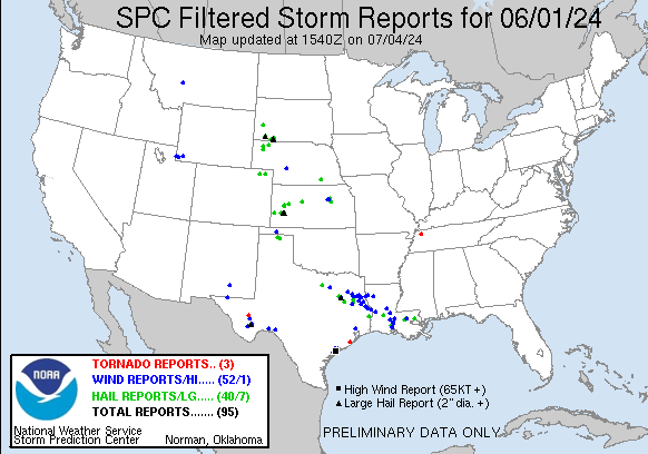
| Tornado Reports (CSV) (Raw Tornado CSV)(?) |
|---|
Time | | Location | County | State | Lat | Lon | Comments |
| 1443 | | 3 ENE Richwood | Brazoria | TX | 2908 | 9536 | [Landspout] Emergency Manager reported Landspout near the intersection of County road 223 and County road 523. (HGX) |
| 2105 | | 1 W Kenton | Gibson | TN | 3620 | 8903 | [Landspout] A brief landspout was observed in extreme northern Gibson County ... causing no damage. (MEG) |
| 2206 | | 15 NNW Hovey | Pecos | TX | 3079 | 10348 | This tornado was reported and photographed as a dusty circulation lasting about 10 minutes in rural Pecos County west of Hovey Road. This circulation may have been a la (MAF) |
| Hail Reports (CSV) (Raw Hail CSV)(?) |
|---|
Time | Size | Location | County | State | Lat | Lon | Comments |
| 1655 | 100 | 2 SSW Aurora | Wise | TX | 3303 | 9753 | Quarter size hail reported just southeast of Boyd ... TX. (FWD) |
| 2028 | 100 | 2 W Dwtn Rapid City | Pennington | SD | 4408 | 10326 | (UNR) |
| 2040 | 125 | 2 ESE Dwtn Rapid City | Pennington | SD | 4407 | 10319 | mPING report (UNR) |
| 2042 | 100 | 2 SW Dwtn Rapid City | Pennington | SD | 4406 | 10326 | mPING report (UNR) |
| 2043 | 100 | Tool | Henderson | TX | 3228 | 9618 | Report from mPING: Quarter (1.00 in.). (FWD) |
| 2043 | 125 | 2 SW Dwtn Rapid City | Pennington | SD | 4407 | 10325 | mPING report (UNR) |
| 2045 | 100 | 1 E Dwtn Rapid City | Pennington | SD | 4407 | 10321 | (UNR) |
| 2048 | 150 | 3 WSW Denham Springs | East Baton Rouge | LA | 3046 | 9101 | Picture of a hailstone with a tape measure just around 1.5 inch/ping pong ball size hail near the intersection of O Neal Ln & Old Hammond Hwy. Relayed by broadcast medi (LIX) |
| 2051 | 100 | 3 SW Enchanted Oaks | Henderson | TX | 3224 | 9613 | Report from mPING: Quarter (1.00 in.). (FWD) |
| 2056 | 200 | 3 SW Enchanted Oaks | Henderson | TX | 3224 | 9613 | Report from mPING: Hen Egg (2.00 in.). (FWD) |
| 2057 | 100 | 3 N Trinidad | Henderson | TX | 3218 | 9610 | Report from mPING: Quarter (1.00 in.). (FWD) |
| 2059 | 125 | 3 SW Denham Springs | East Baton Rouge | LA | 3046 | 9100 | Report from mPING: Half Dollar (1.25 in.). (LIX) |
| 2102 | 250 | Malakoff | Henderson | TX | 3217 | 9601 | (FWD) |
| 2105 | 100 | Walker | Livingston | LA | 3048 | 9087 | Corrects previous hail report from Walker. Several reports of approximately quarter size hail from the Walker area relayed by broadcast media. (LIX) |
| 2105 | 275 | Malakoff | Henderson | TX | 3217 | 9601 | Relayed viewer photo of baseball hail. Time estimated. (FWD) |
| 2106 | 100 | 2 WSW Newton | Newton | TX | 3084 | 9378 | Quarter sized hail reported by a trained spotter. (LCH) |
| 2119 | 100 | Oakdale | Allen | LA | 3082 | 9266 | Photos received of hail up to 1.00 inches in diameter from Oakdale. Time estimated by radar. (LCH) |
| 2200 | 175 | 10 NNW Palestine | Anderson | TX | 3188 | 9573 | Montalba VFD reports golf ball hail. Relayed by emergency management. (FWD) |
| 2200 | 100 | Syracuse | Hamilton | KS | 3798 | 10175 | (DDC) |
| 2209 | 100 | 4 W Covington | St. Tammany | LA | 3047 | 9018 | Off duty NWS employee reports hail up to quarter size near Coquille Park in Covington. (LIX) |
| 2209 | 150 | Syracuse | Hamilton | KS | 3798 | 10175 | Photo on social media. (DDC) |
| 2210 | 100 | 7 E New Summerfield | Cherokee | TX | 3198 | 9499 | Trained spotter reported quarter size hail on the east side of Lake Striker. (SHV) |
| 2223 | 100 | Lakin | Kearny | KS | 3794 | 10126 | (DDC) |
| 2230 | 175 | Deerfield | Kearny | KS | 3799 | 10114 | Relayed by Emergency Management. (DDC) |
| 2232 | 100 | Reklaw | Rusk | TX | 3186 | 9498 | (SHV) |
| 2241 | 150 | Holcomb | Finney | KS | 3799 | 10099 | (DDC) |
| 2243 | 100 | Holcomb | Finney | KS | 3799 | 10099 | Report made via social media. (DDC) |
| 2245 | 200 | 1 N Holcomb | Finney | KS | 3800 | 10099 | Report made via social media. (DDC) |
| 2300 | 300 | 1 N Garden City | Finney | KS | 3799 | 10086 | Report made via social media. (DDC) |
| 2300 | 200 | 2 N Garden City | Finney | KS | 3801 | 10086 | Report made via social media. (DDC) |
| 2305 | 200 | 2 N Garden City | Finney | KS | 3801 | 10086 | Report made via social media. (DDC) |
| 2327 | 100 | Sterling | Logan | CO | 4063 | 10321 | (BOU) |
| 2330 | 175 | Sterling | Logan | CO | 4062 | 10322 | (BOU) |
| 2330 | 100 | Sterling | Logan | CO | 4063 | 10321 | (BOU) |
| 2333 | 125 | 2 WSW Sterling | Logan | CO | 4062 | 10324 | (BOU) |
| 2346 | 175 | 1 N Sterling | Logan | CO | 4065 | 10322 | Also 55 to 60 mph winds. (BOU) |
| 2354 | 100 | 2 W Haxtun | Logan | CO | 4065 | 10267 | Report from mPING: Quarter (1.00 in.). (BOU) |
| 0003 | 100 | Haxtun | Logan | CO | 4063 | 10321 | (BOU) |
| 0025 | 350 | 4 NE Marathon | Brewster | TX | 3026 | 10320 | Corrects previous hail report from 4 NE Marathon. (MAF) |
| 0030 | 300 | 7 E Marathon | Brewster | TX | 3021 | 10312 | (MAF) |
| 0030 | 100 | Shields | Lane | KS | 3862 | 10045 | Reported by Fire Department. (DDC) |
| 0040 | 175 | 18 N Hemingford | Dawes | NE | 4258 | 10308 | Facebook post showing golfball sized hail. (CYS) |
| 0045 | 175 | 18 N Hemingford | Dawes | NE | 4258 | 10308 | Corrects previous hail report from 18 N Hemingford. Facebook post showing golfball sized hail. (CYS) |
| 0100 | 125 | 1 E Hemingford | Box Butte | NE | 4232 | 10306 | Twitter report of 1.28 inch hail 1 East of Hemingford. (CYS) |
| 0100 | 100 | Hemingford | Box Butte | NE | 4232 | 10308 | Twitter photo of nickel to quarter sized hail. (CYS) |
| 0144 | 100 | Rushville | Sheridan | NE | 4271 | 10247 | (LBF) |
| 0156 | 100 | 1 NE Guymon | Texas | OK | 3670 | 10147 | Hail size ranging from dime to quarters at the time of the report. (AMA) |
| 0235 | 100 | 7 SSE Wounded Knee | Oglala Lakota | SD | 4305 | 10231 | (UNR) |
| 0251 | 200 | 8 WSW Swett | Bennett | SD | 4313 | 10210 | (UNR) |
| 0251 | 200 | 3 WNW Batesland | Oglala Lakota | SD | 4314 | 10217 | (UNR) |
| 0255 | 125 | 2 W Toulon | Ellis | KS | 3885 | 9929 | Report made via social media. (DDC) |
| 0259 | 250 | 3 WSW Batesland | Oglala Lakota | SD | 4311 | 10215 | (UNR) |
| 0310 | 125 | 7 NE Batesland | Bennett | SD | 4320 | 10200 | (UNR) |
| 0330 | 200 | 7 NW Oglala | Oglala Lakota | SD | 4326 | 10284 | (UNR) |
| 0355 | 100 | 7 NNE Gruver | Hansford | TX | 3634 | 10135 | Timing was adjusted by radar due to call being after leaving the area of the storm. (AMA) |
| 0430 | 100 | Spearman | Hansford | TX | 3620 | 10119 | Report came from social media. (AMA) |
| 0737 | 100 | Milton | Lafayette | LA | 3010 | 9207 | Video of quarter size hail. (LCH) |
| 0737 | 150 | Bruning | Thayer | NE | 4034 | 9757 | Delayed FB report from storms this morning. (GID) |
| 0755 | 100 | Scott City | Scott | KS | 3848 | 10091 | (DDC) |
| 0840 | 125 | 6 N Scott City | Scott | KS | 3857 | 10091 | Report from social media with picture. (DDC) |
| 0948 | 125 | White City | Morris | KS | 3880 | 9673 | (TOP) |
| 0948 | 100 | 1 ENE Junction City | Geary | KS | 3903 | 9682 | Social media photo. Delayed report. (TOP) |
| Wind Reports (CSV) (Raw Wind CSV)(?) |
|---|
Time | Speed | Location | County | State | Lat | Lon | Comments |
| 1214 | UNK | North Platte | Lincoln | NE | 4114 | 10077 | Large tree limb brought down by thunderstorm winds on the corner of 4th and N Elm Street. Time from radar. (LBF) |
| 1445 | 61 | 2 N Point Comfort | Calhoun | TX | 2869 | 9656 | Mesonet station at Point Comfort ... TX measured a wind gust of 61 mph. (CRP) |
| 1445 | 61 | 12 SSW La Ward | Jackson | TX | 2870 | 9658 | Point Comfort Weatherflow site measured a 61 MPH wind gust. (HGX) |
| 1455 | 62 | 2 SW Port Lavaca | Calhoun | TX | 2860 | 9664 | Tempest weather station in southwest Port Lavaca measured a wind gust of 62 mph at 9:55 AM CDT. (CRP) |
| 1509 | 100 | 1 ENE Magnolia Beach | Calhoun | TX | 2852 | 9650 | Two boats were capsized just offshore. An RV and shed were completely destroyed along State Highway 316. A home along Brighton Ave lost a few shingles and farther south (CRP) |
| 1530 | 64 | 12 E Point Comfort | Calhoun | TX | 2865 | 9636 | Public tempest weather station Co Rd 312 measured a wind gust of 64 mph at 10:30 AM CDT. (CRP) |
| 1530 | 64 | 10 WSW Palacios | Jackson | TX | 2868 | 9639 | Corrects previous tstm wnd gst report from 10 WSW Palacios. El Campo Beach Road Weatherflow site measured a 64 MPH wind gust. (HGX) |
| 1532 | UNK | 3 N Seadrift | Calhoun | TX | 2843 | 9669 | A huge tree uprooted and 3 windows broken at a residence. (a delayed report). (CRP) |
| 1535 | 62 | 9 W Palacios | Jackson | TX | 2872 | 9639 | Trout Street Weatherflow site measured a 62 MPH wind gust. (HGX) |
| 1536 | UNK | 3 NW Seadrift | Calhoun | TX | 2841 | 9672 | Report from mPING: 1-inch tree limbs broken; Shingles blown off. (CRP) |
| 1758 | UNK | 3 NE Irving | Dallas | TX | 3289 | 9694 | Photos of wind damage involving trees ... a metal awning ... and fencing around the Irving PD. Time estimated by radar. (FWD) |
| 1858 | 59 | 1 SE Dayton | Liberty | TX | 3004 | 9488 | Private weather station measured 59 MPH wind gust near Dayton. (HGX) |
| 2044 | UNK | 1 WNW Lindale | Smith | TX | 3251 | 9542 | Trees down on power lines near Circle Drive in Lindale. (SHV) |
| 2102 | 70 | Malakoff | Henderson | TX | 3217 | 9601 | Trained spotter estimates 70 mph wind gust. Multiple trees blown over and metal fence bent. (FWD) |
| 2114 | UNK | 2 NE Walker | Livingston | LA | 3050 | 9084 | Video of large tree falling near N Corbin Road in Walker. Relayed by broadcast media. Time estimated by radar. (LIX) |
| 2122 | UNK | 6 NNE New Chapel Hill | Smith | TX | 3238 | 9511 | Sheriffs office reported trees down at FM 757 and 2767 and in multiple places along FM 757 throughout Smith County. (SHV) |
| 2125 | UNK | 3 N Walker | Livingston | LA | 3052 | 9086 | Report of trees and powerlines down near Walker Rd and Avants Rd in Walker. Time estimated by radar. (LIX) |
| 2135 | UNK | 1 SSE Cecilia | St. Martin | LA | 3032 | 9184 | Utility company reports power outages in associated with strong thunderstorm winds. Area observations observed wind gusts 40 to 50 MPH at the time of the outages. (LCH) |
| 2140 | UNK | 2 SSW Overton | Rusk | TX | 3224 | 9498 | Tree down on FM 2089 just north of the intersection with FM 838 south of Overton. (SHV) |
| 2147 | UNK | 5 ENE New London | Rusk | TX | 3230 | 9487 | Tree down on the southbound lane of US Hwy 259 at CR 146 south of Kilgore. (SHV) |
| 2151 | UNK | Breaux Bridge | St. Martin | LA | 3028 | 9191 | Utility company reporting numerous power outages in Breaux Bridge with thunderstorm passage. (LCH) |
| 2157 | UNK | 1 NW Krotz Springs | St. Landry | LA | 3054 | 9176 | Utility company reporting numerous power outages in the city of Krotz Springs as thunderstorms moved through. (LCH) |
| 2159 | UNK | 5 NE Henderson | Rusk | TX | 3220 | 9474 | Trees down at the intersection of TX Hwy 43 and FM 1251. (SHV) |
| 2210 | UNK | 10 NE Henderson | Rusk | TX | 3224 | 9467 | Trees down at the intersection of TX Hwy 43 and CR 2144. (SHV) |
| 2211 | UNK | 4 WSW Tatum | Rusk | TX | 3229 | 9457 | Power lines down on TX Hwy 43 near Martin Creek Lake. (SHV) |
| 2219 | UNK | 2 W Cottonport | Avoyelles | LA | 3099 | 9209 | Report of trees and powerlines down on Dora road between Cottonport and Evergreen. Time estimated by radar. (LCH) |
| 2219 | UNK | 4 NNW Garrison | Rusk | TX | 3187 | 9452 | Tress down at the intersection of FM 1971 and FM 95. (SHV) |
| 2221 | 61 | 1 N Dell City | Hudspeth | TX | 3195 | 10520 | Mesonet station 91 Dell City (TTU/WTM). (EPZ) |
| 2221 | 58 | 3 W Evanston | Uinta | WY | 4127 | 11103 | ASOS station KEVW Evanston-Uinta Cnty Airport. (SLC) |
| 2229 | UNK | 1 W Opelousas | St. Landry | LA | 3052 | 9210 | Report of tree down on Mouton Street in Opelousas. Time estimated by radar. (LCH) |
| 2229 | UNK | Cottonport | Avoyelles | LA | 3099 | 9205 | Broadcast media reports trees down in Cottonport. Times estimated by radar. (LCH) |
| 2232 | 61 | Evanston | Uinta | WY | 4126 | 11098 | Mesonet station WY7 Evanston. (SLC) |
| 2232 | 62 | 5 N Altamont | Uinta | WY | 4128 | 11080 | Wind gust of 62 mph reported at KFIR I80/US189 First Divide. (SLC) |
| 2240 | UNK | Carthage | Panola | TX | 3217 | 9434 | Widespread trees and powerlines downed across the entire county. (SHV) |
| 2248 | UNK | 2 WNW Parks | St. Martin | LA | 3023 | 9186 | Utility company reports power outages in associated with strong thunderstorm winds. Area observations observed wind gusts up to 30 MPH at the time of the outages. (LCH) |
| 2250 | 63 | 3 SSE Carter | Uinta | WY | 4139 | 11041 | Wind gust of 63 mph reported at KFBR Fort Bridger Airport. (SLC) |
| 2256 | UNK | 3 S Hovey | Brewster | TX | 3057 | 10335 | Multiple power poles found snapped along a nearly one mile span on US67 near Hovey Rd. Time estimated from radar. (MAF) |
| 2302 | UNK | 4 NW Keachi | Caddo | LA | 3222 | 9397 | Trees down across the road near the intersection of Keithville-Keatchie Road and Hunsicker Lane east of the Four Forks community. (SHV) |
| 2317 | UNK | Stonewall | De Soto | LA | 3227 | 9382 | Large oak tree uprooted. 100ft of fences blown over near Kingfisher Trail in Stonewall off of Stonewall Frierson Road. Estimated winds of 60 to 70 mph. (SHV) |
| 2320 | UNK | 5 NNW Alto | Cherokee | TX | 3172 | 9510 | Delayed report of trees down along Highway 69 between Rusk and Alto. (SHV) |
| 2323 | UNK | 10 NNW Chireno | Nacogdoches | TX | 3164 | 9443 | Trees down on Hwy 7 west of Martinsville. (SHV) |
| 2325 | UNK | 1 WNW Center | Shelby | TX | 3180 | 9419 | Widespread trees and powerlines downed throughout the county. (SHV) |
| 2356 | UNK | 5 E San Augustine | San Augustine | TX | 3154 | 9403 | Widespread trees and powerlines downed across mainly the northern half of the County. (SHV) |
| 0005 | UNK | 2 WNW Hall Summit | Red River | LA | 3218 | 9333 | Large limbs down near the intersection of Hwy 514 and Hwy. 783 west of Hall Summit. (SHV) |
| 0022 | 61 | 4 E Marathon | Brewster | TX | 3021 | 10317 | Mesonet station UR285 4.4 E Marathon (UPR). (MAF) |
| 0033 | UNK | 1 ENE Hemphill | Sabine | TX | 3135 | 9384 | Widespread trees and powerlines downed across the entire county. (SHV) |
| 0036 | 60 | 1 NE Dunken | Chaves | NM | 3282 | 10518 | Mesonet station DUNN5 Dunken 2 NE (Dunken). (ABQ) |
| 0055 | UNK | 17 SSW Florien | Sabine | LA | 3122 | 9357 | Several Trees downed across the far southern portion of the parish ... especially along Hwy 191 near Curtis Store. (SHV) |
| 0122 | UNK | Leesville | Vernon | LA | 3113 | 9328 | Utility company reports power outages in association with strong thunderstorm winds. (LCH) |
| 0142 | 61 | 1 WSW Guymon | Texas | OK | 3668 | 10151 | (AMA) |
| 0149 | 61 | 19 SW Marathon | Brewster | TX | 3003 | 10347 | This was likely caused by an outflow boundary ahead of severe thunderstorms to the north. Mesonet station EMNT2 Elephant Mtn Wma Raws. (MAF) |
| 0152 | UNK | 5 ESE Alexandria | Rapides | LA | 3126 | 9239 | 911 Center reports a tree fell on an 18 wheeler as it was traveling down HWY 1. No injuries. (LCH) |
| 0259 | UNK | 9 NE Townsend | Broadwater | MT | 4639 | 11135 | Report from mPING: 1-inch tree limbs broken; Shingles blown off. (TFX) |
| 0345 | 65 | 22 ESE Dryden | Terrell | TX | 2997 | 10176 | Mesonet station UR206 16.5 NW Langtry (UPR). (MAF) |
| 0425 | 61 | 14 N Seminole Canyon St | Val Verde | TX | 2989 | 10127 | Mesonet station TWB98 Gray Ranch. (EWX) |
| 0745 | UNK | 4 S Youngsville | Vermilion | LA | 3004 | 9199 | Several Trees Reported Down in the Champagne Subdivision. (LCH) |
| 0745 | UNK | 3 S Youngsville | Lafayette | LA | 3006 | 9199 | Public reported damage evidence to the area that included trees snapped / broken ... chimney tops blown off roof ... and downed power lines. Picture evidence shows accumu (LCH) |
| 0757 | UNK | Jefferson Island | Iberia | LA | 2997 | 9197 | Photos on social media showing extensive tree damage at Rip Van Winkle Gardens. Time estimated by radar. (LCH) |
| 0829 | UNK | 4 ENE Chapman | Geary | KS | 3899 | 9694 | Delayed report. Large tree branch 1-2 feet in diameter broken off tree. Time estimated from radar. (TOP) |
| 0834 | UNK | Chapman | Dickinson | KS | 3897 | 9702 | Large tree limb down (4 inch). (TOP) |


 @NWSSPC