|
20210627's Storm Reports (20210627 1200 UTC - 20210628 1159 UTC) (Print Version)
|
< 210626 Reports
210628 Reports >
|
| Note: All Reports Are Considered Preliminary |
|
|
|
|
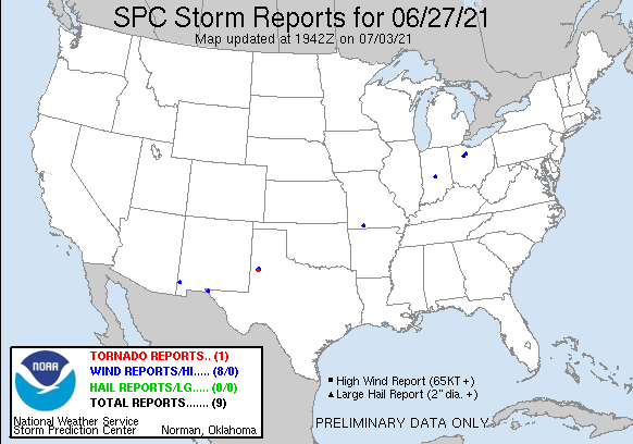
| Tornado Reports (CSV) (Raw Tornado CSV)(?) |
|---|
Time | | Location | County | State | Lat | Lon | Comments |
| 0154 | | 1 S OPDYKE WEST | HOCKLEY | TX | 3357 | 10230 | BRIEF ROPE - NO DAMAGE REPORTED (LUB) |
| Hail Reports (CSV) (Raw Hail CSV)(?) |
|---|
| No reports received |
| Wind Reports (CSV) (Raw Wind CSV)(?) |
|---|
Time | Speed | Location | County | State | Lat | Lon | Comments |
| 1620 | UNK | 1 NNW OPDYKE | HOCKLEY | TX | 3361 | 10228 | TWO 12 KVA POLES SNAPPED (LUB) |
| 1620 | UNK | 2 N OPDYKE WEST | HOCKLEY | TX | 3362 | 10230 | REPORTS OF POWER FLASHES (LUB) |
| 1806 | UNK | 2 NW WALNUT SHADE | TANEY | MO | 3675 | 9322 | TRAFFIC ON HIGHWAY 65 HAD TO COME TO A STOP DUE TO THUNDERSTORM WINDS. ONE CAR WAS REPORTEDLY BLOWN OFF THE HIGHWAY INTO THE GRASS. (SGF) |
| 2025 | 62 | 3 NNE EL PASO | EL PASO | TX | 3190 | 10642 | SPOTTER MEASURES WIND GUST TO 62 MPH. 1/2 INCH HAIL WITH THUNDERSTORM. 1.03 INCHES OF RAINFALL AT THE TIME OF OBSERVATION. (EPZ) |
| 2123 | UNK | WHARTON | WYANDOT | OH | 4086 | 8346 | LARGE TREE BRANCH DOWN OVER ROAD. (CLE) |
| 2135 | 59 | 8 ENE ROAD FORKS | HIDALGO | NM | 3228 | 10888 | (EPZ) |
| 2140 | UNK | 5 NNW SYCAMORE | SENECA | OH | 4101 | 8321 | POWER POLE WITH WIRES DOWN OVER TOWNSHIP ROAD 131. (CLE) |
| 0115 | 59 | INDIANAPOLIS INT'L AIRP | MARION | IN | 3972 | 8629 | WIND MEASUREMENT OF 51 KTS AT THE KIND ASOS. (IND) |
|
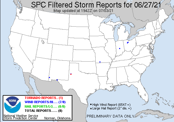
| Filtered Tornado Reports (CSV) (Raw Tornado CSV)(?) |
|---|
Time | | Location | County | State | Lat | Lon | Comments |
| 0154 | | 1 S OPDYKE WEST | HOCKLEY | TX | 3357 | 10230 | BRIEF ROPE - NO DAMAGE REPORTED (LUB) |
| Filtered Hail Reports (CSV) (Raw Hail CSV)(?) |
|---|
| No reports received |
| Filtered Wind Reports (CSV) (Raw Wind CSV)(?) |
|---|
Time | Speed | Location | County | State | Lat | Lon | Comments |
| 1620 | UNK | 2 N OPDYKE WEST | HOCKLEY | TX | 3362 | 10230 | REPORTS OF POWER FLASHES (LUB) |
| 1806 | UNK | 2 NW WALNUT SHADE | TANEY | MO | 3675 | 9322 | TRAFFIC ON HIGHWAY 65 HAD TO COME TO A STOP DUE TO THUNDERSTORM WINDS. ONE CAR WAS REPORTEDLY BLOWN OFF THE HIGHWAY INTO THE GRASS. (SGF) |
| 2025 | 62 | 3 NNE EL PASO | EL PASO | TX | 3190 | 10642 | SPOTTER MEASURES WIND GUST TO 62 MPH. 1/2 INCH HAIL WITH THUNDERSTORM. 1.03 INCHES OF RAINFALL AT THE TIME OF OBSERVATION. (EPZ) |
| 2123 | UNK | WHARTON | WYANDOT | OH | 4086 | 8346 | LARGE TREE BRANCH DOWN OVER ROAD. (CLE) |
| 2135 | 59 | 8 ENE ROAD FORKS | HIDALGO | NM | 3228 | 10888 | (EPZ) |
| 2140 | UNK | 5 NNW SYCAMORE | SENECA | OH | 4101 | 8321 | POWER POLE WITH WIRES DOWN OVER TOWNSHIP ROAD 131. (CLE) |
| 0115 | 59 | INDIANAPOLIS INT'L AIRP | MARION | IN | 3972 | 8629 | WIND MEASUREMENT OF 51 KTS AT THE KIND ASOS. (IND) |
| The Storm Reports page is organized based on reports received from 1200 UTC to 1159 UTC the next day. For example, storm report page for 20150430 covers reports from 20150430 at 1200 UTC to 20150501 at 1159 UTC. |
| Full report in comma-separated values (CSV) format and in KML format. |
| Full filtered report in comma-separated values (CSV) format and in KML format. |
| KML files are created with time-enabled placemarks compatible with Google Earth Time Slider. |
| Raw full report in comma-separated values (CSV) format. |
| Fields marked UNK are unknown. |
| All Times UTC. |
| Wind Gusts in MPH. |
| Hail Sizes in 1/100 of an Inch (175 = 1.75") |
| LAT/LON in decimal degrees to two decimals, see SPC FAQ for more info. |
| List of Weather Forecast Office 3-letter IDs appear in the report comments section. |
|
|
|
Top/Storm Reports/Home
|
|
|


 @NWSSPC