20210627's Storm Reports (20210627 1200 UTC - 20210628 1159 UTC)
|
< 210626 Reports
210628 Reports >
|
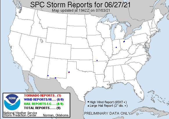
| Tornado Reports (CSV) (Raw Tornado CSV)(?) |
|---|
Time | | Location | County | State | Lat | Lon | Comments |
| 0154 | | 1 S OPDYKE WEST | HOCKLEY | TX | 3357 | 10230 | BRIEF ROPE - NO DAMAGE REPORTED (LUB) |
| Hail Reports (CSV) (Raw Hail CSV)(?) |
|---|
| No reports received |
| Wind Reports (CSV) (Raw Wind CSV)(?) |
|---|
Time | Speed | Location | County | State | Lat | Lon | Comments |
| 1620 | UNK | 1 NNW OPDYKE | HOCKLEY | TX | 3361 | 10228 | TWO 12 KVA POLES SNAPPED (LUB) |
| 1620 | UNK | 2 N OPDYKE WEST | HOCKLEY | TX | 3362 | 10230 | REPORTS OF POWER FLASHES (LUB) |
| 1806 | UNK | 2 NW WALNUT SHADE | TANEY | MO | 3675 | 9322 | TRAFFIC ON HIGHWAY 65 HAD TO COME TO A STOP DUE TO THUNDERSTORM WINDS. ONE CAR WAS REPORTEDLY BLOWN OFF THE HIGHWAY INTO THE GRASS. (SGF) |
| 2025 | 62 | 3 NNE EL PASO | EL PASO | TX | 3190 | 10642 | SPOTTER MEASURES WIND GUST TO 62 MPH. 1/2 INCH HAIL WITH THUNDERSTORM. 1.03 INCHES OF RAINFALL AT THE TIME OF OBSERVATION. (EPZ) |
| 2123 | UNK | WHARTON | WYANDOT | OH | 4086 | 8346 | LARGE TREE BRANCH DOWN OVER ROAD. (CLE) |
| 2135 | 59 | 8 ENE ROAD FORKS | HIDALGO | NM | 3228 | 10888 | (EPZ) |
| 2140 | UNK | 5 NNW SYCAMORE | SENECA | OH | 4101 | 8321 | POWER POLE WITH WIRES DOWN OVER TOWNSHIP ROAD 131. (CLE) |
| 0115 | 59 | INDIANAPOLIS INT'L AIRP | MARION | IN | 3972 | 8629 | WIND MEASUREMENT OF 51 KTS AT THE KIND ASOS. (IND) |
|
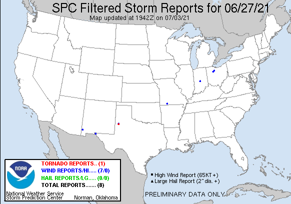
| Filtered Tornado Reports (CSV) (Raw Tornado CSV)(?) |
|---|
Time | | Location | County | State | Lat | Lon | Comments |
| 0154 | | 1 S OPDYKE WEST | HOCKLEY | TX | 3357 | 10230 | BRIEF ROPE - NO DAMAGE REPORTED (LUB) |
| Filtered Hail Reports (CSV) (Raw Hail CSV)(?) |
|---|
| No reports received |
| Filtered Wind Reports (CSV) (Raw Wind CSV)(?) |
|---|
Time | Speed | Location | County | State | Lat | Lon | Comments |
| 1620 | UNK | 2 N OPDYKE WEST | HOCKLEY | TX | 3362 | 10230 | REPORTS OF POWER FLASHES (LUB) |
| 1806 | UNK | 2 NW WALNUT SHADE | TANEY | MO | 3675 | 9322 | TRAFFIC ON HIGHWAY 65 HAD TO COME TO A STOP DUE TO THUNDERSTORM WINDS. ONE CAR WAS REPORTEDLY BLOWN OFF THE HIGHWAY INTO THE GRASS. (SGF) |
| 2025 | 62 | 3 NNE EL PASO | EL PASO | TX | 3190 | 10642 | SPOTTER MEASURES WIND GUST TO 62 MPH. 1/2 INCH HAIL WITH THUNDERSTORM. 1.03 INCHES OF RAINFALL AT THE TIME OF OBSERVATION. (EPZ) |
| 2123 | UNK | WHARTON | WYANDOT | OH | 4086 | 8346 | LARGE TREE BRANCH DOWN OVER ROAD. (CLE) |
| 2135 | 59 | 8 ENE ROAD FORKS | HIDALGO | NM | 3228 | 10888 | (EPZ) |
| 2140 | UNK | 5 NNW SYCAMORE | SENECA | OH | 4101 | 8321 | POWER POLE WITH WIRES DOWN OVER TOWNSHIP ROAD 131. (CLE) |
| 0115 | 59 | INDIANAPOLIS INT'L AIRP | MARION | IN | 3972 | 8629 | WIND MEASUREMENT OF 51 KTS AT THE KIND ASOS. (IND) |
|
| Full report in comma-separated values (CSV) format and in KML format. |
| Full filtered report in comma-separated values (CSV) format and in KML format. |
| Raw full report in comma-separated values (CSV) format |
| Fields marked UNK are unknown |
| All Times UTC |
| Wind Gusts in MPH |
| Hail Sizes in 1/100 of an Inch (175 = 1.75\") |
| LAT/LON in decimal degrees to two decimals, see SPC FAQ for more info |
| List of Weather Forecast Office 3-letter IDs appear in the report comments section |
|
|
|
Top/Storm Reports/Home
|