
NOAA/NWS Storm Prediction Center, Norman, Oklahoma
and
Michael D. Vescio
NWS, Ft. Worth, Texas
Forecasters at the Storm Prediction Center were faced with many challenges during the 3 May 1999 tornado outbreak. Operational numerical forecast models valid during the outbreak gave inaccurate, inconsistent and/or ambiguous guidance to forecasters, most notably with varying convective precipitation forecasts and underforecast wind speeds in the middle and upper troposphere, which led forecasters (in the early convective outlooks) to expect a substantially reduced tornado threat compared to what was observed. That, combined with relatively weak forecast and observed low-level convergence along a dryline, contributed to much uncertainty regarding timing and location of convective initiation. Consequently, as the event approached, observational diagnosis and analysis became more important, and were critical in identification of the evolution of the outbreak. Ultimately, tornadic supercells developed earlier, were more numerous, and produced more significant tornadoes than anticipated. While forecasters dealt with the meteorological facets of the tornadic storms the evening of 3 May 1999, there were other areas of simultaneous severe storm development, and one of the tornadoes posed a threat to the facility and family members of the forecast staff. These uncertainties and challenges are discussed in the context of SPC convective outlooks and watches for this outbreak. Recommendations are made for continued research aimed at improving forecasts of convective initiation and mode.
From the late afternoon into the nocturnal hours of 3-4 May 1999, a violent tornado outbreak affected portions of central and northern Oklahoma and southern Kansas, with ten tornadic supercells responsible for over sixty tornado reports (Speheger et al. 2001). Long_lived, violent (F4_F5 damage) tornadoes occurred in the Oklahoma City, Oklahoma and Wichita, Kansas metropolitan areas, as well as in the small towns of Mulhall and Dover to the north and northwest of Oklahoma City. [For mapping of the supercells and tornadoes, and a post-mortem overview of the meteorology of the event, refer to Thompson and Edwards 2000, hereafter TE00.]
The Storm Prediction Center (SPC) in Norman, Oklahoma, has nationwide responsibility for forecasting organized severe local storm threats. SPC was actively involved in providing synoptic scale outlook guidance, mesoscale discussions (MDs) and severe weather watches (WWs) for the 3 May 1999 event (see Ostby (1992, 1999) for an overview of SPC’s forecast products and services). Except for the addition of two more convective outlooks to the daily product schedule (issued at 01 and 13 UTC), the basic suite of products discussed by Ostby (1992) is the same as that which was available on 3 May 1999 (see Table 1 for the 1999 SPC outlook schedule). Additionally, the 13 and 20 UTC Day-1 convective outlooks were accompanied by a set of experimental probabilistic forecasts (Kay and Brooks 2000) for tornadoes, severe hail and severe thunderstorm wind – products which were extended to all Day-1 and Day-2 outlooks in 2000 and which became fully operational in January 2001. Also, during this event, watch status reports routinely contained short discussions regarding the degree or location of the greatest threat within a WW area. However, starting in 2000, more frequent MD products within WWs have taken the place of status narratives; and as of this writing, the status report is primarily a set of points representing the ending of the severe weather threat within a WW area 1.
Many meteorological parameters associated with this outbreak were characteristic of other severe weather outbreaks in the southern Plains; however, the pre-convective evolution of this event presented substantial challenges to SPC forecasters in large part because of ambiguous and often conflicting diagnostic and prognostic information available before the event. The resulting uncertainties delayed recognition of the magnitude of the impending outbreak and, in particular, delayed upgrade of the categorical convective outlook from “slight” to “moderate” risk until 1630 UTC 3 May. These uncertainties arose from two primary factors:
The purpose of this article is to focus operational and research attention on these critical forecast issues by documenting their influence on SPC’s handling of the 3 May event, and to discuss some of the lessons learned. Also, the unique operational environment of SPC is briefly discussed as applied to the 3 May 1999 outbreak.
The large suite of operational and experimental numerical model guidance was available to the SPC at the time of the outbreak, with the most commonly used output being that from the Eta (Black 1994), Rapid Update Cycle 2 (RUC2, see Smith et al. 2000) and Aviation (Kanamitsu 1989) model runs. In the initial forecasts for this event – the Day-2 outlooks – the Eta and Aviation were most thoroughly examined. During the Day-1 outlook periods, the Eta was the model most intensively utilized because of both 1) its timeliness relative to product deadlines, and 2) the SPC’s operational perception of the Eta as being the most reliable short-range model for forecasting environmental conditions conducive to severe thunderstorms. The hourly RUC2, valid for no more than 12 h after initialization, was also examined frequently during the morning, afternoon and evening of 3 May 1999.
In the Day-2 and early Day-1 forecasting time frames, a concern for SPC forecasters was model performance with respect to the character and evolution of the synoptic scale pattern, as depicted by forecasts of upper level winds and geopotential heights on mandatory pressure levels (e.g., 500 mb and 250 mb). Data at these mandatory pressure levels are often used by SPC forecasters as a component of “pattern recognition” forecasting typically invoked in the Day-2 and initial Day-1 outlooks (e.g., Johns and Doswell 1992). Beginning early in the Day-1 forecast period, forecaster assessment of the forecast large scale pattern and smaller scale details was hindered somewhat by Eta model forecast errors detected through subjective examination of 500 mb and 250 mb geopotential heights and wind speeds. The forecast valid at 12 UTC 3 May from the 00 UTC 3 May 1999 Eta run appeared to be underestimating wind speeds in the middle and upper troposphere, thus casting uncertainty upon associated forecasts of vertical wind shear, and the timing and position of troughs in the height patterns. The distribution and magnitude of vertical shear, along with the location and intensity of a middle- to upper-tropospheric speed maximum, were each considered important factors in determining the mode and coverage of deep convection. These concerns were conveyed to the later forecasting shifts (namely the day shift on 3 May), thereby encouraging the day shift forecasters to rely more heavily on observational data than the explicit model forecasts. Similarly, inconsistent Eta and RUC2 forecasts of precipitation introduced considerable uncertainty not only for that field, but also for critical parameters incorporating moisture and instability. This includes convective available potential energy (CAPE), which can be acutely sensitive to whether a model turns on its convective parameterization (e.g., Baldwin et al, 2000). In spite of the noted model forecast problems with the operational models in the 3 May 1999 case, general forecasts of vertical wind shear and CAPE appeared generally supportive of supercells in a relatively broad area from Texas to Kansas.
The upper-tropospheric jet pattern during the pre-dawn hours of 2 May 1999, as the initial Day-2 forecast was prepared, featured a large scale, negatively tilted trough, the axis of which was oriented from north-northwest to south-southeast over the Rockies, with an embedded jet streak over southern New Mexico (Fig. 1). In association with the jet streak, a lee trough over the high Plains had induced southeasterly low-level flow that had brought deep moisture northward over southern and western Texas (Fig. 2). Forecast passage of the New Mexico jet streak in a cyclonically curving, northeastward to northward path across the high Plains on 2 May was expected to 1) maintain low-level southerly flow over most of the southern Plains, boosting confidence that substantial northward moisture transport would continue through the afternoon of 3 May, and 2) veer flow above the boundary layer over the south-central U.S. This, in turn, was expected to contribute to low level air being diabatically heated and vertically mixed on higher terrain (an elevated mixed layer, after Carlson et al 1983, and Lanicci and Warner 1991). The elevated mixed layer (EML) then would be advected northeastward atop the moistening boundary layer over the southern plains, leading to large CAPE. SPC forecasters generally consider lapse rates approaching dry adiabatic (e.g., >9 C km-1 in the 700-500 mb layer) as extreme; and Eta forecast lapse rates were substantially less – generally around 7.5 C km-1. Still, it was recognized that such values could support severe convection given the presence of low-level moisture already observed across Texas and the Gulf of Mexico, as well as sufficient moisture and low-level lift to initiate deep convection.


Even as early as the period in which the Day-2 outlook was being prepared, forecasters questioned the strength of low-level ascent which could potentially lead to convective initiation. Pressure falls over the Dakotas were expected to maintain a large southerly surface flow component on both sides of a dryline, which was expected to become more sharply defined as moisture increased to its east. Nevertheless, confidence was strong that vertical wind shear, storm-relative flows (Thompson 1998) and instability would be at least adequate for a supercell and tornado threat, given convective initiation. For example, 48 h forecasts from the 00 UTC 2 May Eta2 run showed 1000-500 mb velocity differences at least 35 kt (18 ms-1) over most of Oklahoma and northern Texas, with values approaching 50 kt (25 ms-1) beneath the southern jet branch in southern Texas, and most unstable parcel CAPE (MUCAPE) greater than 2500 J kg-1 over a broad swath of the Plains from Nebraska through Texas.
Despite the large forecast area of favorable CAPE and shear, the absence of both a significant low- level forcing mechanism for upward motion east of the dryline and a well-defined trough in the mid- and upper troposphere forecast by the Eta and Aviation models, along with a prominent lack of Eta convective precipitation from Nebraska southward over Texas (Fig. 3), diminished confidence in development of a widespread or unusually intense severe thunderstorm threat. Therefore, the potential for organized severe thunderstorms on 3 May was deemed a “slight risk”3 in the 0730 UTC 2 May issuance of the SPC categorical Day-2 outlook (Fig. 4).


This reasoning was continued through the 1730 UTC 2 May update of the Day-2 outlook (Fig. 4), largely because of the close resemblance of patterns in shear, instability and lift in the 1200 UTC 2 May Eta (not shown) to those from previous runs. The newer model run did, however, produce precipitation in the moist sector from central Texas to southern and eastern Kansas after 00 UTC 4 May. [Because the operational Eta did not extend beyond the 48 h forecast period at the time, corresponding model forecasts from the 00 UTC run were unavailable for comparison.] The patchy, erratic spatial distribution of forecast precipitation in this run was further evidence that forcing for convective development would be subtle, and that meso- to storm-scale processes would strongly influence convective mode.
The Day-1 outlooks issued at 06 and 13 UTC 3 May incorporated observed trends of both the low-level thermodynamic fields and the position and movement of upper tropospheric features evident in water vapor channel satellite imagery. That far in advance of the potential event, though, each forecast was still greatly dependent upon numerical model predictions of fields critical for severe weather prediction, including vertical shear, CAPE, storm-relative flows and precipitation. Major uncertainties remained regarding the degree of severe weather risk over the region, including these considerations: where within the relatively broad “slight” risk area (e.g., Figs. 5a-b) the greatest threat existed (i.e., the potential “moderate” risk), when severe convection would develop, and what convective mode (e.g., supercellular, multicellular or linear) would predominate.
 a
a  b
b  c
c  d
d  e
e
Model forecast kinematic and instability parameters – including BRN shear and CAPE (e.g., Weisman and Klemp 1986), 0-6 km shear above ground level, and storm-relative winds – appeared to support supercells, and some potential for tornadoes. However, given the continuing uncertainties regarding model guidance, convective initiation and convective mode, the decision was made to maintain the severe thunderstorm risk as “slight.” The general consensus, in telephone coordination with the NWS Forecast Office in Norman, was that an upgrade to “moderate” risk category could be required during the day which would include some portion of Oklahoma, Kansas and/or northern Texas, once analytic evidence made foci and potential morphology of convection clearer.
The 00 UTC 3 May Eta model run predicted deepening of the middle- and upper-tropospheric trough and intensification of wind flow over the Rockies and Four Corners regions by 00 UTC 4 May. However, it was apparent from rawinsonde and profiler winds at 12 UTC 3 May that the 00 UTC 3 May Eta was underforecasting the strength of these fields (Figs. 6a-b). Forecast errors of 500 mb heights from the 00 UTC model run ultimately exceeded 100 m over the southwestern U.S. by 00 UTC 4 May, and wind speeds were 10-15 kt stronger than forecast over the outbreak region4 (Figs. 6c-d).
 a
a  b
b  c
c 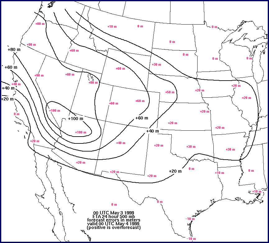 d
d
Thermodynamic support for severe weather was clearly evident, with surface dew points expected to increase through the middle and upper 60s F (roughly 18-20 C). These values would contribute to forecast surface-based CAPE (SBCAPE) greater than 2500 J kg-1 in the moist sector from Kansas to Texas. In conjunction with strong boundary layer mixing over the high Plains, the increasing moist sector dew points would help to establish a dryline roughly from south-central Nebraska across western portions of Oklahoma and over west-central Texas. There was a disturbing lack of boundaries to focus convective initiation away from the forecast dryline as well, which was apparent from observations and numerical forecasts through the day. In the absence of significant low-level boundaries, subtle boundary layer processes become critical for convective initiation, and forecasts of storm-scale phenomena intrinsically will have large uncertainty (Crook 1996).
Most of the thunderstorms were expected to form around 00 UTC 4 May. By that time, the mid- and upper-tropospheric trough was expected to approach the area from the west, along with an increase in model-forecast boundary layer moisture flux convergence near the dryline. The 00 UTC 3 May Eta model forecasts produced precipitation within the warm sector across north-central and northeastern Texas and southern Oklahoma before 00 UTC 4 May (not shown) – east of the dryline and near no apparent boundary. Forecasters generally disregarded that precipitation guidance since this aspect of the Eta forecast was inconsistent with the two previous runs. The model’s convective precipitation also led to a pronounced under-forecast of CAPE (Weiss 1996, Stensrud and Weiss 2001), which was likewise disregarded in the modeled precipitation areas. In addition, modified Eta forecast soundings from 18-24 hours prior to the outbreak (not shown) indicated a probability that any supercells which formed during late afternoon could become characterized by excessive outflow because of forecasts of relatively weak (8 m s-1) storm-relative winds in the middle troposphere, limiting the tornado threat (Thompson 1998). These same forecast soundings also showed relatively weak storm-relative winds in the upper troposphere (12 m s-1) which have been shown to contribute to heavy precipitation (HP) supercell character (Rasmussen and Straka 1998).
In the transition from the initial convective outlooks (made during the previous evening and overnight) to the daylight hours of 3 May, forecaster attention shifted from model wind and vertical shear forecasts to observed data. Water vapor satellite imagery suggested the presence of an upper tropospheric speed maximum moving eastward into New Mexico during mid to late morning (roughly 14 to 17 UTC). The inferred presence of this speed maximum was confirmed during the late morning and early afternoon hours by a time series of profiler winds5 from New Mexico, western Texas and western Oklahoma (see TE00 for details). These increasingly ominous synoptic and meso-a scale (Orlanski 1975) clues for strengthening vertical shear, in combination with strong instability, led to an upgrade of the categorical outlook to “moderate risk” at 1630 UTC (Fig. 5c), and an additional upgrade to “high risk” followed in the 20 and 01 UTC outlooks (Figs. 5d-e). Despite these factors that appeared supportive of an increasing supercell and tornado threat from Texas to Kansas, substantial uncertainties remained regarding the character, timing and location of convective development during the late morning and afternoon of 3 May.
Eta model precipitation fields from the 12 UTC 3 May run (not shown) revealed a cluster of thunderstorms by 18 UTC over portions of northern and northeastern Texas, and an accompanying surface trough along the Red River. This guidance was a substantial change from the 00 UTC 3 May Eta run, and was disregarded in light of contradictory observational trends, including a lack of well-defined kinematic or baroclinic boundaries east of the dryline upon which convection could develop. The RUC2, in contrast, showed a tendency to generate very little precipitation in the warm sector over Texas and Oklahoma from morning through late afternoon. The 18 UTC run predicted a small area of convective precipitation in southwestern Oklahoma by 21 UTC (Fig. 7a); but it consisted of minimal accumulations, and was forecast to dissipate by the 00-03 UTC 4 May period (Figs. 7b-d). There was a warm and dry bias6 in the RUC2 forecasts that was unknown to SPC forecasters on 3 May 1999. [Forecast Systems Laboratory 40 km resolution reruns7 of the 3 May case produced a more realistic precipitation forecast across north Texas and southern Oklahoma, but did not necessarily capture the location or intensity of the actual deep convection.]
 a
a  b
b  c
c  d
d
Consecutive categorical risk upgrades were made in the 1630 and 20 UTC Day-1 outlooks. Thermodynamic fields and upper-level flow patterns were becoming progressively more favorable for a major severe weather event. Observed 12 UTC soundings and model soundings from the 12 UTC runs, modified for expected late afternoon surface thermodynamic conditions, yielded weak convective inhibition (negative buoyancy) of less than 50 J kg-1 and SBCAPE values increasing to >4000 J kg-1. The buoyancy was trending into the climatologically extreme range for strong to violent tornado situations8 (Johns et al. 1993), given the forecast storm-relative helicity (SRH) above 200 m2 s-2. As the day progressed, those favorable factors more convincingly overcame lingering contradictory evidence, including: 1) mixed signals from more recent numerical guidance, 2) concerns about limited insolation under a cirriform cloud deck (TE00), and 3) continued observational and forecast weakness of low-level convergence. Accordingly, it was recognized by mid morning that the potential for strong to violent tornadoes was increasing, given afternoon and/or evening convective development, as conveyed in the following 1630 UTC Day-1 outlook text:
...N CENTRAL TX/OK/SRN KS...
LOW LEVEL JET WILL MAINTAIN SIGNIFICANT INFLOW OF LOW LEVEL MOISTURE WITH
SURFACE DEWPOINTS AROUND 65F.  CLEARING SKIES EVIDENT ON VISIBLE IMAGES WILL
FURTHER CONTRIBUTE TO STRONG DESTABILIZATION OVER REGION WITH LATE
AFTERNOON MUCAPES FORECASTED FROM 3500 TO 4500 J/KG OVER MDT RISK AREA.  AS
SHORT WAVE APPROACHES WRN OK/TX BORDER...LIFTING WILL DEEPEN NEAR/ALONG
DRYLINE WITH THUNDERSTORMS INCREASING AS THEY MOVE EWD INTO INSTABILITY AXIS.
50 KT MID LEVEL SWLY FLOW SPREADING OVER LOW LEVEL JET AXIS WILL PROVIDE
SUFFICIENT SHEAR FOR A FEW STRONG OR VIOLENT TORNADIC SUPERCELLS GIVEN THE
ABUNDANT LOW LEVEL MOISTURE AND THE HIGH INSTABILITY.

As trends in instability (based on 18 UTC observed and model forecast soundings) and shear reinforced the possibility of a significant severe weather episode, the 20 UTC categorical outlook was upgraded to a “high” risk (Fig. 5d) and the accompanying experimental tornado probability outlook included a significant tornado area across western Oklahoma (Fig. 8). Shortly after 20 UTC, the mesoscale forecaster issued an MD which highlighted an area east of the dryline in southwestern Oklahoma and northwestern Texas where the most intense juxtaposition of moisture, instability and vertical wind shear was located. The MD text follows:
SPC MESOSCALE DISCUSSION #0345 FOR...SW OK/NW TX...
CONCERNING...SEVERE THUNDERSTORM POTENTIAL...

WATER VAPOR IMAGERY SHOWS A LEAD MID LEVEL SHORTWAVE TROUGH MOVING ENEWD
 OVER E/NE NM THIS AFTERNOON...AND THIS IS CONFIRMED BY PROFILER TIME SERIES FROM
AZC/GDA/TCC/JTN.  MID/UPPER 60 DEWPOINTS AND TEMPERATURES NEAR 80 ARE
CONTRIBUTING TO SURFACE-BASED CAPE VALUES OF 3500-5000 J/KG OVER WRN OK AND NW
TX TO THE E OF THE DRYLINE.  CONVERGENCE ON THE DRYLINE IS NOT STRONG AND A
CIRRUS SHIELD OVER THE TX PANHANDLE/NW TX/WRN OK SHOULD LIMIT ADDITIONAL
SURFACE HEATING...BUT VISIBLE/RADAR IMAGERY HAS SHOWN THE FIRST ATTEMPTS AT
TCU OVER FAR NW TX AS OF 20Z WITHIN A BREAK IN THE CIRRUS.  MID LEVEL FLOW AND
VERTICAL SHEAR WILL INCREASE OVER NW TX AND WRN OK THROUGH LATE
AFTERNOON...WITH AN INCREASING THREAT OF SUPERCELLS NEAR THE DRYLINE FROM 00-
03Z.  THIS AREA IS BEING MONITORED FOR A POSSIBLE TORNADO WATCH LATER THIS
AFTERNOON.
Between 2000 and 2015 UTC, the initial towering cumuli and brief cumulonimbi in northwestern Texas dissipated. Additional development followed from 2030-2100 UTC, over southwestern Oklahoma. By 22 UTC, the first two supercells were present; these would become the two most prolific tornado producers in the outbreak (Storms A and B, after TE00 and Speheger et al. 2001). Though forecasters had begun to suspect a supercell and tornado threat before dark, development occurred two to three hours sooner than forecast. Thunderstorm initiation along such subtle features as an apparent horizontal convective roll (HCR) (Edwards et al., 2000) was not anticipated, nor were major strengthening trends in supercells and tornadoes associated with a confluence line detectable in mesonet wind plots (TE00).
Initial forecaster concerns during the evening shift (which began at 21 UTC) regarded whether or not the isolated deep convection in southwestern Oklahoma (early stages of storm A) would persist much longer than the recently failed convection in northwestern Texas. Observations available at the beginning of the evening shift did not yet reveal the strong increase in low-level wind shear in the region where cumulonimbi were forming. This did not become apparent in profiler wind plots until approximately 23 UTC. The first WW, tornado watch 195 for central and southwestern Oklahoma, was issued at 2130 UTC (after a coordination call to the Norman NWS office) when satellite and radar imagery revealed intensification of storm A and explosive development of a second storm in southwestern Oklahoma (storm B). This watch became effective over half an hour before the first significant tornado ( at least F2 damage), and preceded the F5 tornado by over 2.5 hours. It was relatively small in size by design, to 1) allow SPC more time to monitor convective evolution before further WW issuance, and 2) to expedite issuance of the WW by minimizing the time required for NWS inter-office telephone coordination (only the Norman NWS office jurisdiction was affected). Nine additional WWs were subsequently issued throughout the remainder of the afternoon and evening as numerous tornadic supercells formed over Oklahoma, and as severe thunderstorms formed from the Dakotas to southwestern Texas (Fig. 9).
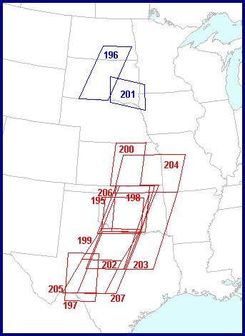
Adjacent areas of severe weather concern were evident throughout the process of providing forecasts for this event – starting with the Day-2 outlook and continuing through the MD and WW issuances on the evening of 3-4 May. SPC severe weather outlooks and WWs extended across much of the central U.S. (Fig. 9); and severe weather was reported throughout much of the Plains (Fig. 10). Some attention was necessarily devoted to those areas throughout the outlook process and into the time frame of the southern Plains outbreak, even though the highest priority was given to the more potentially life-threatening events over Oklahoma and Kansas.

As is standard practice at SPC, subjective, mesoscale surface map analyses were performed for all severe weather threat areas, and MDs were issued for heavy rainfall both within and outside the primary tornado outbreak region of Kansas and Oklahoma. The 01 UTC (4 May) outlook update (Fig. 5e) drew continued attention to the outlying convective threats while maintaining a “high” risk over the Oklahoma/Kansas outbreak area. Also, telephone calls were made to numerous NWS offices for coordination of WWs and discussion of severe weather threats. By 2254 UTC, for example, tornado watch 197 was required for southwest Texas, as convection was developing along the dryline west of San Angelo, with another isolated supercell north of Del Rio. The occurrence of multiple severe weather threats and heavy rain potential, all requiring SPC forecasting guidance and NWS inter-office coordination, is quite common from mid spring through summer. Beginning with the preparation of the 13 UTC (3 May 1999) Day-1 outlook, and becoming much more frequent during the outbreak that afternoon and evening, telephone coordination was undertaken with NWS offices in the region for watch issuances, threat clearance lines and mesoscale nowcasting.
One critical element in operational forecasting is shift-to-shift continuity, meteorological conditions permitting. During potential or actual severe weather events at SPC, this is done through detailed shift-change briefings at all forecast desks. These briefings use subjective, national map analyses to maintain synoptic perspective, followed by focusing on the mesoscale and smaller environments. On this day, convective initiation around the 21 UTC shift change allowed the evening shift very little time to analyze and diagnose the situation before numerous WWs were required. The watch issuance strategy was complicated greatly by thunderstorm initiation occurring somewhat sooner than expected, and just minutes before the arrival of the evening shift for briefing. Because the cumulonimbus which would become Storm A was developing away from all known surface boundaries, there remained great uncertainty as to where subsequent convection would occur. The watch layout was deferred to the evening shift lead forecaster. Despite the problems posed by the timing of the shift change, continuity provided by the briefing allowed the evening shift meteorologists to assess the situation as quickly as possible. A watch was soon issued for Oklahoma which covered the initiation region of most of the subsequent supercells, as well as recently initiated Storms A and B. This shift change highlighted the importance of maintaining a continuous meteorological surveillance, using thorough subjective analysis to minimize familiarization time required by succeeding shifts.
Finally, a unique logistic threat was posed for the first known time in the history of SPC (and its predecessor, the Severe Local Storms Unit of the National Severe Storms Forecast Center): the distinct possibility of the operational facility and/or families of on-duty employees being in the path of a tornado known to be very large and destructive. By 2330 UTC, local television news video showed a wide, long-lived tornado moving toward the southern portion of the Oklahoma City area from the southwest. SPC forecasters became concerned that the tornado could persist and strike parts of northwestern Norman – perhaps even the SPC facility. At 2355 UTC SPC notified the Air Force Weather Agency (AFWA), at Offutt Air Force Base near Omaha, that they may have to assume backup responsibility if the SPC were to be struck or otherwise incapacitated by the tornado. Duty staff also called family members – many of whom resided closer than SPC to the eventual damage path – to advise them on preparing for the approaching storm. The tornado persisted with F4-F5 damage across the southern and eastern portions of the Oklahoma City area and missed the SPC by several miles, though it was faintly visible from the facility’s roof. Fortunately, no forecasters’ families or homes were directly affected.
Unlike many “synoptically evident” severe weather outbreaks (after Doswell et al. 1993), the 3 May 1999 tornado event was strongly dependent upon convective initiation by weak, subtle, and/or heretofore unknown mesoscale processes. Similar, but less well publicized situations had been recognized operationally for several years – such as an outbreak containing killer tornadoes in Arkansas earlier the same year. Like the 3 May event, the 21 January 1999 tornadic supercells over Arkansas appeared to develop in a favorably unstable and strongly sheared warm sector, with only subtle kinematic and thermodynamic foci for convective development. Some of these features, like HCRs, do not appear in mesoanalytic conventions. Unlike 3 May, the 21 January outbreak was preceded by consistent and accurate Eta model precipitation forecasts, which led to greater forecaster confidence and a much earlier upgrade of the categorical convective outlook to “high” risk. Despite the differences in model precipitation forecasts for each event, the 3 May outbreak brought forth the idea that weak low-level lift can be beneficial for supercell development and maintenance in situations where capping is also small (TE00). This represents an amendment to the well-established “synoptically evident” severe local storms forecasting paradigm – a shift which, in effect, argues, “weaker forcing can be more favorable.” Cases like 21 January and 3 May 1999 suggest that there is a delicate balance between the convective mode extremes of no thunderstorms, multiple tornadic supercells, and numerous thunderstorms in clusters or squall lines. Events of this nature bring up the question, “Where do the critical distinctions lie with regard to convective initiation and storm character?” Because of the great difference in public danger represented by these convective modes across a potentially small adjustment in the environment (e.g., Brooks et al. 1993), much research effort is warranted into observing and simulating differing storm morphologies in weakly convergent air masses.
Successful forecasting of tornado outbreaks, and severe weather in general, requires careful, detailed diagnoses of real-time observational data and trends, regardless of the frequency, resolution, or accuracy of numerical guidance. This is crucial when important yet subtle mesoscale and storm scale processes cannot be resolved by model input data, and/or develop after model initialization, such as on 3 May 1999. Such real-time analyses of kinematic and thermodynamic trends, surface and aloft, were aided greatly by the presence of profiler wind data, visible, infrared, and water vapor satellite imagery, WSR-88D-derived winds, and surface observations from the Oklahoma mesonet (Brock et al. 1995). Ready availability of observational data and meticulous attention to detail also allow forecasters to “ramp up” a weather hazard forecast just ahead of an event which may have been unforecast or underforecast in earlier decades, when some diagnostic data were either coarser in resolution (satellite imagery) or altogether unavailable (e.g., surface mesonets, wind profilers and WSR-88D winds). Convective forecasting capabilities could be improved further in the future by increased operational awareness and availability of supplemental and/or experimental observational data sources of high spatial and temporal density, such as the atmospheric emitted radiance interferometers (Mecikalski and Feltz 2000), which were running on 3 May 1999.
Greater scientific knowledge and situational awareness on the part of severe storms forecasters (e.g., Ostby 1999) plays a major role in adjusting outlooks and other guidance to rapidly evolving, highly challenging events like the 3 May outbreak as well. Operationally valuable work has been published related to this area since the outbreak, but much more is needed. For example, Weckwerth (2000) has documented the sensitivity of deep moist convective development to moisture distribution, which may become exceptionally important to nowcasting thunderstorm formation in the absence of strong baroclinic boundaries such as fronts or outflows. Weaver and Avissar (2001) simulated mesoscale vertical circulations and surface heat fluxes conducive to convective cloud development, caused by landscape inhomogeneities of human origin in Oklahoma and Kansas; they found that the circulations were not necessarily mitigated by increasing ambient winds. Mesoscale model simulations by Roebber et al. (2001) indicate that 1) insolation beneath the cirrus gap documented by TE00 was strong enough to lead to convective initiation, and 2) the potential vorticity filament (jet streak) moving overhead during the outbreak was sufficiently deep to strengthen low-level convergence, further enhancing convective development. Detection of subtle mechanisms influencing initiation – in the case of 3 May 1999, HCRs, confluence lines, vertically deep jet streaks, and cloud layer edges – can be crucial because of the uncertainty they can impart to the convective forecast (Crook 1996). Thus, mesoscale prediction of their development, location, and strength can also be a critical factor in improving convective forecasts. It is in the convective initiation forecasting problem where ready availability (and ease of use) of mesoscale models and high-density observational sampling may provide the greatest operational benefit.
Forecasters at SPC routinely examine the various model precipitation forecasts to aid in delineating areas of thunderstorm potential, especially in situations of subtle low-level forcing such as the 3 May 1999 outbreak. Confidence that storms will form in a given area is boosted if one or more models generate precipitation in the area of concern, particularly with run-to-run consistency. This was not the case here, as operational models failed to predict correctly or consistently the convective initiation timing and location. Further, observed trends in kinematic fields and geopotential heights revealed substantial model errors. SPC forecasters, though faced with some important uncertainties as discussed above, were able to disregard or modify such model guidance using analytic and physical reasoning. However, this event serves to alert forecasters that excessive reliance on model guidance in such situations, at the expense of examining real-time observations, not only increases the potential for inaccuracy, but can be dangerous when the quality of watches and warnings for deadly events is affected.
Numerical model guidance can be helpful in anticipating synoptic to meso-a scale developments relevant to the smaller scales. There is some promise in the development of short-range ensemble techniques for reducing uncertainty in convective forecasts (Stensrud and Weiss 2001). However, given the meso-b to storm scale detail and nonlinearity of features and processes associated with convective development, severe weather threat assessment will always require both objective and subjective analyses of real-time observational data. For numerical models to become “perfect” severe storms predictors, they may require not only complete and theoretically infallible physics packages, but also “perfect” initial analysis fields. The latter can not be achieved given meso-beta scale and larger data voids in the surface and upper air observational input, both over land and upstream oceans, since perturbations on smaller scales can heavily influence convective initiation and mode. However, continued improvements in model physics, parameterization, resolution, and in the density and quality of observational input , are expected to reduce the risk of “surprise” severe weather outbreaks further, and to lengthen the advance notice of their potential occurrence. The trends in numerical modeling toward more dense spatial resolution, more complicated physics, and ensemble systems each pose challenges for forecasters in effectively utilizing such guidance (e.g., Brooks and Doswell 1993), particularly when faced with a proliferation of other prognostic and diagnostic information sources to examine within operational time constraints.
Finally, during severe weather outbreaks, NWS forecasters are faced with short-fuse decisions amidst a work environment of 1) routine products with required deadlines, 2) increased distraction in the form of phone calls, event documentation and other non-scheduled tasks, and 3) less time to diagnose and predict the situation given an increasing volume of prognostic and diagnostic information as discussed above. Forecasters must prioritize tasks and weather threats, “load shedding” some of them within the constraints of deadlines and duties. This is done with a nontrivial risk of mistakes. Operational data processing and analysis efforts must consider the ability of forecasters to absorb and process broad arrays of information in a timely, well-prioritized manner during extreme weather situations. This likely will require cross-discipline cooperation across the fields of meteorology, psychology and computer science, in order to optimally balance forecaster workload and performance.
Acknowledgments
We greatly appreciate the keen guidance of Bob Johns and Steve Weiss (SPC) in the development and organization of this article, as well as other colleagues at SPC and NSSL for internal reviews and constructive suggestions at various stages. The SPC Scientific Support Branch provided ready access to the data used in figures and text. Chuck Doswell, John Monteverdi and an anonymous reviewer helped greatly through their critiques in the formal review process.
Baldwin, M. E., M. P. Kay, and J. S. Kain, 2000: Properties of the convective scheme in NCEP's Eta model that affect forecast sounding analysis. Preprints, 20th Conf. on Severe Local Storms, Orlando, FL, Amer. Meteor. Soc., 447-448.
Black, T.L., 1994: The new NMC mesoscale Eta model: Description and forecast examples. Wea. Forecasting, 9, 265-278.
Brock, F.V., K. C. Crawford, R.L. Elliott, G.W. Cuperus, S.J. Stadler, H.L. Johnson, and M.D. Eilts, 1995: The Oklahoma Mesonet: A technical overview. J. Atmos. Oceanic Technol., 12, 5-19.
Brooks, H.E., and C.A. Doswell III, 1993: New technology and numerical weather prediction: A wasted opportunity? Weather, 48, 173-177.
_____, C.A. Doswell III, and R. Davies_Jones, 1993: Environmental helicity and the maintenance and evolution of low_level mesocyclones. The Tornado: Its Structure, Dynamics, Prediction and Hazards. Geophys. Monogr. 79, C. Church, Ed., Amer. Geophys. Union, 97_104.
Carlson, T.N., S.G. Benjamin, G.S. Forbes, and Y.-F. Li, 1983: Elevated mixed layers in the severe storm environment - conceptual model and case studies. Mon. Wea. Rev., 111, 1453-1473.
Crook, N.A., 1996: Sensitivity of moist convection forced by boundary layer processes to low level thermodynamic fields. Mon. Wea. Rev., 124, 1767-1785.
Doswell, C.A., III, and E.N. Rasmussen, 1994: The effect of neglecting the virtual temperature correction on CAPE calculation. Wea. Forecasting, 9, 625-629.
_____, S. J. Weiss, and R. H. Johns, 1993: Tornado forecasting – a review. The Tornado: Its Structure, Dynamics, Prediction, and Hazards. Geophys.Mongr., 79, Amer. Geophys. Union, 557-571.
Edwards, R., R.L. Thompson and J.G. LaDue, 2000: Initiation of storm A (3 May 1999) along a possible horizontal convective roll. Preprints, 20th Conf. on Severe Local Storms, Orlando, FL, Amer. Meteor. Soc., 60-63.
Johns, R.H., J.M. Davies, and P.W. Leftwich, 1993: Some wind and instability parameters associated with strong and violent tornadoes. Part II: Variations in the combinations of wind and instability parameters. The Tornado: Its Structure, Dynamics, Prediction, and Hazards. Geophys. Mongr., 79, Amer. Geophys. Union, 583-590.
_____, and C. A. Doswell III, 1992: Severe local storms forecasting. Wea. Forecasting, 7, 588-612.
Kanamitsu, M., 1989: Description of the NMC Global Data Assimilation and Forecast System. Wea. Forecasting, 4, 335-342.
Kay, M.P., and H.E. Brooks, 2000: Verification of probabilistic severe storm forecasts at the SPC. Preprints, 20th Conf. on Severe Local Storms, Orlando, FL, Amer. Meteor. Soc., 285-288.
Lanicci, J.M., and T.T. Warner, 1991: A synoptic climatology of the elevated mixed-layer inversion over the southern Great Plains. Part II: The life cycle of the lid. Wea. Forecasting, 6, 198-213.
Mecikalski, J.R., and W.F. Feltz, 2000: Nowcasting the 3 May 1999 Oklahoma tornado outbreak using the AERI ground_based interferometer. Preprints, 20th Conf. on Severe Local Storms, Orlando, FL, Amer. Meteor. Soc., 25-28.
Orlanski, I., 1975: A rational subdivision for atmospheric processes. Bull. Amer. Meteor. Soc., 56, 527-530.
Ostby, F.P., 1999: Improved accuracy in severe storm forecasting by the Severe Local Storms Unit during the last 25 years: Then versus now. Wea. Forecasting, 14, 526-543.
_____, 1992: Operations of the National Severe Storms Forecast Center. Wea. Forecasting, 7,546-563.
Rasmussen, E.N., and J.M. Straka, 1998: Variations in supercell morphology. Part I: Observations of the role of upper-level storm-relative flow. Mon. Wea. Rev., 126, 2406-2421.
Roebber, P.J., D.M. Schultz and R. Romero, 2001: Synoptic regulation of the 3 May 1999 tornado outbreak. Wea. Forecasting, (this issue).
Smith, T.L., S.G. Benjamin, B.E. Schwartz, and G. Grell, 2000: A past and future look at the Rapid Update Cycle for the 3 May 1999 severe weather outbreak. Preprints, 20th Conf. on Severe Local Storms, Orlando, FL, Amer. Meteor. Soc., 21-24.
Speheger, D.A., C.A. Doswell III, and G.J. Stumpf, 2001: Documentation of Tornadoes on 3 May 1999 in the NWS Norman County Warning Area. Wea. Forecasting, (this issue).
Stensrud, D.J., and S.J. Weiss, 2001: Mesoscale model ensemble forecasts of the 3 May 1999 tornado outbreak. Wea. Forecasting, (this issue).
Thompson, R.L., 1998: Eta model storm_relative winds associated with tornadic and nontornadic supercells. Wea. Forecasting, 13, 125_137.
_____, and R. Edwards, 2000: An overview of environmental conditions and forecast implications of the 3 May 1999 tornado outbreak. Wea. Forecasting, 15, 682-699.
U. S. Department of Commerce, 1999: Storm Data, 41 (5). [Available from National Climatic Data Center, Asheville, NC 28801.]
Weaver, C.P., and R. Avissar, 2001: Atmospheric disturbances caused by human modification of the landscape. Bull. Amer. Meteor. Soc., 82, 269-281.
Weckwerth, T.M., 2000: The effect of small-scale moisture variability on thunderstorm initiation. Mon. Wea. Rev., 128, 4017-4030.
Weisman, M.L., and J. B. Klemp, 1986: Characteristics of isolated convective storms. Mesoscale Meteor. And Forecasting, P. S. Ray, Ed., Amer. Meteor. Soc., 331-358.
Weiss, S.J., 1996: Operational evaluation of the Mesoeta model for the prediction of severe local storms. Preprints, 18th Conf. on Severe Local Storms, San Francisco, CA, Amer. Meteor. Soc., 367-371.
FOOTNOTES
1 [The current SPC product suite is described on the website ( (http://www.spc.noaa.gov).]
2 In 1999, the Eta model forecast output extended through 48 hours, corresponding to only the first half of the initial Day-2 outlook period. Out of necessity, the initial Day-2 outlook relied on a blend of Eta and Aviation model guidance to cover the entire 24 hour forecast period.
3 The term “slight risk” means that severe thunderstorms are expected to develop, but not with widespread coverage. It is not meant to be interpreted in the same way as, for example, a local precipitation forecast. The inherent ambiguity in categorical severe thunderstorm risk terminology led to development of the probabilistic outlooks (Kay and Brooks 2000), which the SPC was issuing experimentally on 3 May 1999.
4 The information contained in Figs.6c-d was neither available at the time of these early Day-1 outlooks, nor until after the outbreak was in progress.
5 Profiler winds were not incorporated into the operational RUC2 on 3 May 1999.
6The operational RUC2 carried a warm and dry bias at the surface caused by a vegetation fraction erroneously set to zero (Smith et al., 2000).
7These reruns, unlike the operational RUC, included wind profiler data, used different cloud microphysics and convective parameterization, and were run at 40, 20 and 10 km grid resolution. See Smith et al. (2000) for details.
8The Johns et al. study only examined conditions when strong and violent tornadoes occurred. The frequency of those conditions without significant tornadoes was not considered. Doswell and Rasmussen (1994) give a national CAPE climatology for a year without regard to the presence of significant tornadoes, showing that 4000 J kg-1 is a rarely achieved value.
Back to SPC Publications